
Pinkham's Grant is a township located in Coos County, New Hampshire, United States. As of the 2010 census, the grant had a total population of 9.

Dinara is a mountain located on the border of Bosnia and Herzegovina and Croatia. It has two major peaks: Troglav and the eponymous Dinara. The peak called Dinara is the highest peak of Croatia, is shaped like a human head made of stone, and also has a prominence of 728 m.

War Memorial Stadium, also known as Jonah Field at War Memorial Stadium, is an outdoor college football stadium on the campus of the University of Wyoming in Laramie. It is the home field of the Wyoming Cowboys of the Mountain West Conference. The field is named after a natural gas field at the Green River Basin in Sublette County.

The Wildcat Hills are an escarpment between the North Platte River and Pumpkin Creek in the western Panhandle, in the state of Nebraska in the Great Plains region of the United States. Located in Banner, Morrill, and Scotts Bluff counties, the high tableland between the streams has been eroded by wind and water into a region of forested buttes, ridges and canyons that rise 150 to 300 m above the surrounding landscape.

Wildcat Mountain is a mountain located in Coos County, northern New Hampshire, United States. The mountain is part of the Carter-Moriah Range of the White Mountains, on the east side of Pinkham Notch. Wildcat Mountain faces Carter Dome across Carter Notch to the northeast, and Mount Washington across Pinkham Notch to the west.

The Carter-Moriah Range of mountains is located in the White Mountains, in Coos County, New Hampshire. The range forms the northern east side of Pinkham Notch, opposite the northern Presidential Range. The range is also referred to as the Carter Range.

Wildcat Mountain State Park is a state park of Wisconsin, United States, on the Kickapoo River in the Driftless Area. Sandstone bluffs topped with limestone, two of which are Wildcat Mountain and Mount Pisgah, provide views over the narrow valley of the river and its tributaries. The Kickapoo Valley Reserve is immediately adjacent and forms a continuous protected area. Wildcat Mountain State Park is open for year-round recreation including hiking, canoeing, fishing, and cross-country skiing. The 3,643-acre (1,474 ha) park is located in Vernon County near the town of Ontario, Wisconsin.
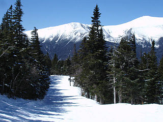
Wildcat Mountain Ski Area is a ski area located on Wildcat Mountain near Jackson, New Hampshire, United States, in the Mount Washington Valley. Its vertical drop of 2,112 feet (644 m) is the second largest in New Hampshire and the ninth largest in New England.

Wildcat Mountain is a summit in Iron County, Missouri, located 1.4 miles (2.3 km) west of Taum Sauk Mountain, Missouri's highest peak. Wildcat Mountain's summit elevation is only about two feet less than that of Taum Sauk Mountain.

Wallface Mountain is a mountain located in Essex County, New York. The mountain is named after the cliff on its southeastern side. Wallface is flanked to the west by MacNaughton Mountain, and faces Mount Marshall to the southeast across Indian Pass.

The Bare Mountain Range is a mountain range in southern Nye County, Nevada, in the United States. Bare Mountain and Wildcat Peak are the high points of the range.

The Little Harquahala Mountains are a small, arid, low-elevation mountain range of western-central Arizona, in the southeast of La Paz County.

The Granite Wash Mountains are a short, arid, low elevation mountain range of western-central Arizona, in the southeast of La Paz County. The range borders a slightly larger range southeast, the Little Harquahala Mountains; both ranges form a section on the same water divide between two desert washes. The washes flow in opposite directions, one northwest to the Colorado River, the other southeast to the Gila River.

Wildcat is an unincorporated community in Lewis County, West Virginia, United States. Wildcat is located along the Little Kanawha River and County Route 50, 20 miles (32 km) south-southeast of Weston.

The Lake Mountains are a 15-mile-long (24 km) mountain range located on the western edge of the Utah Valley in northwestern Utah County, Utah, United States. The range forms the northwest border of Utah Lake, and its proximity allows its use for communication towers, mostly in its north section, bordering Eagle Mountain.
Wildcat Creek is a tributary of the Lackawanna River in Lackawanna County, Pennsylvania, in the United States. It is approximately 3.8 miles (6.1 km) long and flows through Archbald and Blakely. The watershed of the creek has an area of 4.49 square miles (11.6 km2). It has one named tributary, which is known as West Branch Tinklepaugh Creek. The creek may lose flow to coal measures and may receive only intermittent flow even at its source. Only the upper reaches of the creek have a natural channel. It flows through an open box culvert in its lower reaches.

Van Wyck Mountain is a mountain located in the Catskill Mountains of New York east-southeast of Frost Valley. Hemlock Mountain is located north, Woodhull Mountain is located west-southwest, Samson Mountain is located southeast, Bangle Hill is located south, and Wildcat Mountain is located northwest of Van Wyck Mountain.
Beaver Kill Range is a mountain located in the Catskill Mountains of New York west-northwest of Frost Valley. Wildcat Mountain is located east-southeast, Cradle Rock Ridge is located north, and Mongaup Mountain is located west-southwest of Beaver Kill Range.

Huntersfield Mountain is a mountain located in the Catskill Mountains of New York north-northwest of Ashland. Ashland Pinnacle is located east, and Tower Mountain is located south-southeast of Huntersfield Mountain. It is the highest point in Schoharie County and it is ranked 9 of 62 on the list of New York County High Points.
Mount Pisgah is a mountain located in the Catskill Mountains of New York north of Windham. Steenburg Mountain is located northwest, Richtmyer Peak is located west, and Mount Nebo is located southeast of Mount Pisgah.


