
Aspen is the Home Rule City that is the county seat and the most populous municipality of Pitkin County, Colorado, United States. The city population was 7,004 at the 2020 United States Census. Aspen is in a remote area of the Rocky Mountains' Sawatch Range and Elk Mountains, along the Roaring Fork River at an elevation just below 8,000 feet (2,400 m) on the Western Slope, 11 miles (18 km) west of the Continental Divide. Aspen is now a part of the Glenwood Springs, CO Micropolitan Statistical Area.

Rocky Mountain National Park is a national park of the United States located approximately 55 mi (89 km) northwest of Denver in north-central Colorado, within the Front Range of the Rocky Mountains. The park is situated between the towns of Estes Park to the east and Grand Lake to the west. The eastern and western slopes of the Continental Divide run directly through the center of the park with the headwaters of the Colorado River located in the park's northwestern region. The main features of the park include mountains, alpine lakes and a wide variety of wildlife within various climates and environments, from wooded forests to mountain tundra.

Roaring Fork River is a tributary of the Colorado River, approximately 70 miles (110 km) long, in west central Colorado in the United States. The river drains a populated and economically vital area of the Colorado Western Slope called the Roaring Fork Valley or Roaring Fork Watershed, which includes the resort city of Aspen and the resorts of Aspen/Snowmass.

The Chequamegon–Nicolet National Forest is a 1,530,647-acre (6,194.31 km2) U.S. National Forest in northern Wisconsin in the United States. Due to logging in the early part of the 20th century, very little old growth forest remains. Some of the trees there were planted by the Civilian Conservation Corps in the 1930s. The national forest land trees and vegetation are part of the North Woods Ecoregion that prevails throughout the upper Great Lakes region.

The Chetco River is a 56-mile-long (90 km) stream located in the southwestern portion of the U.S. state of Oregon. It drains approximately 352 square miles (912 km2) of Curry County. Flowing through a rugged and isolated coastal region, it descends rapidly from about 3,200 feet (975 m) to sea level at the Pacific Ocean. Except for the lowermost 5 miles (8 km), the river is located entirely within the Rogue River – Siskiyou National Forest. The river rises in the Kalmiopsis Wilderness, northwest of Chetco Peak at the junction of the Oregon Coast Range and the Klamath Mountains. It flows generally north, west, and then southwest, before emptying into the ocean between Brookings and Harbor, approximately 6 miles (10 km) north of the California state line. The Chetco River's watershed remains largely undeveloped, protected by the Rogue River – Siskiyou National Forest and the Kalmiopsis Wilderness. The upper 45 miles (72 km) of the river have been designated Wild and Scenic since 1988.
The Wind River is a tributary of the East Fork Chandalar River in the U.S. state of Alaska. It arises in the Philip Smith Mountains of the Brooks Range and flows into the East Fork and eventually into the Yukon River.

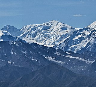
Aspen Mountain is a mountain summit in the Elk Mountains range of the Rocky Mountains of North America. The 11,212-foot (3,417 m) peak is located in White River National Forest, 1.4 miles (2.2 km) south-southeast of downtown Aspen in Pitkin County, Colorado, United States. The north face of the mountain is the location of the Aspen Mountain ski area, one of four adjacent ski areas operated collectively as Aspen/Snowmass.

White River National Forest is a National Forest in northwest Colorado. It is named after the White River that passes through its northern section. It is the most visited National Forest in the United States, primarily from users of the twelve ski areas within its boundaries.

The Maroon Bells are two peaks in the Elk Mountains, Maroon Peak and North Maroon Peak, separated by about half a kilometer. The mountains are on the border between Pitkin County and Gunnison County, Colorado, United States, about 19 kilometres (12 mi) southwest of Aspen. Both peaks are fourteeners. Maroon Peak, at 4,317 metres (14,163 ft), is the 27th highest peak in Colorado. North Maroon Peak, at 4,273 metres (14,019 ft), is the 50th highest. The view of the Maroon Bells to the southwest from the Maroon Creek valley is very heavily photographed. The peaks are located in the Maroon Bells–Snowmass Wilderness of White River National Forest. Maroon Bells-Snowmass Wilderness was one of five areas in Colorado designated as wilderness in the original Wilderness Act of 1964. The Wilderness area surrounds the extremely popular Maroon Bells Scenic Area, which is a major access point for Wilderness travel.

Bridger–Teton National Forest is located in western Wyoming, United States. The forest consists of 3.4 million acres, making it the third largest National Forest outside Alaska. The forest stretches from Yellowstone National Park, along the eastern boundary of Grand Teton National Park and from there rides along the western slope of the Continental Divide to the southern end of the Wind River Range. The forest also extends southward encompassing the Salt River Range and Wyoming Range mountains near the Idaho border.

The Bridger Wilderness is located in Bridger-Teton National Forest in Wyoming, United States. Originally established in 1931 as a primitive area, 428,169-acre (1,732.74 km2) region was redesignated as a wilderness in 1964 and expanded to the current size in 1984. The wilderness lies on the west side of the Continental Divide in the Wind River Range and contains Gannett Peak; at 13,809 feet (4,209 m) it is the tallest mountain in Wyoming. The wilderness is a part of the Greater Yellowstone Ecosystem.
Aspen is a common name for several species of trees in the genus Populus and for some in the genus Acronychia.

Populus tremuloides is a deciduous tree native to cooler areas of North America, one of several species referred to by the common name aspen. It is commonly called quaking aspen, trembling aspen, American aspen, mountain or golden aspen, trembling poplar, white poplar, and popple, as well as others. The trees have tall trunks, up to 25 metres tall, with smooth pale bark, scarred with black. The glossy green leaves, dull beneath, become golden to yellow, rarely red, in autumn. The species often propagates through its roots to form large clonal groves originating from a shared root system. These roots are not rhizomes, as new growth develops from adventitious buds on the parent root system.
Mount Silverthrone is 13,220 ft (4,030 m) glaciated mountain summit located in Denali National Park and Preserve, in the Alaska Range, in the U.S. state of Alaska. It is situated 10.8 mi (17 km) east of Denali. The first ascent of this peak was made April 12, 1945, by Norman Bright and Frank P. Foster. It was so named by the U.S. Army Forces Cold Weather test party because of its stately appearance at the head of Brooks Glacier.

The Medomak River, historically known as the Muscongus River, is a 40-mile-long (64 km) river in Maine. From its source in Liberty, the river winds 32 miles (51 km) south to the head of its tidal river estuary in Waldoboro, then about 8 miles (13 km) south to Bremen. The river flows through Hockomock Channel into the head of Muscongus Bay. Medomak is Abenaki for "place (river) of many alewives".

The ecology of the Rocky Mountains is diverse due to the effects of a variety of environmental factors. The Rocky Mountains are the major mountain range in western North America, running from the far north of British Columbia in Canada to New Mexico in the southwestern United States, climbing from the Great Plains at or below 1,800 feet (550 m) to peaks of over 14,000 feet (4,300 m). Temperature and rainfall varies greatly also and thus the Rockies are home to a mixture of habitats including the alpine, subalpine and boreal habitats of the Northern Rocky Mountains in British Columbia and Alberta, the coniferous forests of Montana and Idaho, the wetlands and prairie where the Rockies meet the plains, a different mix of conifers on the Yellowstone Plateau in Wyoming, the montane forests of Utah, and in the high Rockies of Colorado and New Mexico, and finally the alpine tundra of the highest elevations.

The interior Alaska–Yukon lowland taiga is an ecoregion in the taiga and boreal forests biome, of far northern North America.
The Aspen Brook is a 3.9-mile-long (6.3 km) tributary of the Big Thompson River in Larimer County, Colorado. The stream's source is near Wind River Pass. It flows north to a confluence with the Big Thompson in Rocky Mountain National Park.

Aspen is a common name for certain tree species in the Populus sect. Populus, of the Populus (poplar) genus.
