The Great Western Highway is a 201-kilometre-long (125 mi) state highway in New South Wales, Australia. From east to west, the highway links Sydney with Bathurst, on the state's Central Tablelands.
Metroads were the primary road routes serving the Sydney and Brisbane metropolitan areas from the 1990s to the early 2010s. The Metroads formed a network of radial and circumferential routes throughout the cities, simplifying navigation. Metroads have been progressively phased out in both Sydney and Brisbane, replaced by alphanumeric route numbers. Brisbane is the only city currently retaining the Metroad system.

The A6 is an arterial road linking Cumberland Highway at Carlingford and Princes Highway at Heathcote, via Lidcombe and Bankstown. It was formerly designated as Metroad 6, which was one of the Sydney Metroads.

The A4 and M4 is an arterial route in Sydney, Australia. It connects the Inner West of Sydney with the outer western suburbs. It used to be Metroad 4, which was a Metroad in Sydney.
Northmead is a suburb of Greater Western Sydney, in the state of New South Wales, Australia. Northmead is located 26 kilometres west of the Sydney central business district, in the local government area of the City of Parramatta.

The A3 is a major metropolitan arterial route in Sydney. It was formerly designated as Metroad 3. The A3 runs from its intersection with the A8 at Mona Vale at the north end, to the southerly of its two intersections with A1, the Princes Highway, at Blakehurst the south end. The highest speed limit on the (A3) is 90 km/h (56 mph) on Mona Vale Road.
The M2 is a route in Sydney, New South Wales, Australia, that links Sydney suburbs from Artarmon in the south-east to Bella Vista in the north-west. The route consists of two separately named motorways, the M2 Hills Motorway and the Lane Cove Tunnel.

The A9 is the outer western Sydney Bypass connecting Campbelltown to Windsor. It was formerly designated Metroad 9, which was one of Sydney's Metroads.

The Cumberland Highway is a 34-kilometre (21 mi) long urban highway located in Sydney, New South Wales, Australia. The highway links the Pacific Highway (A1/B83) and Pacific Motorway (M1) at Pearces Corner, Wahroonga in the northeast with the Hume Highway (A22/A28) at Liverpool in the southwest.

Parramatta Road is the major historical east-west artery of metropolitan Sydney, New South Wales, Australia, connecting the Sydney CBD with Parramatta. It is the easternmost part of the Great Western Highway. Since the 1980s its role has been augmented by the City West Link Road and M4 Motorway.

The Hills District is a customary region of Sydney, within the northern part of the Greater Western Sydney region of Sydney, in the state of New South Wales, Australia. Stretching from the M2 Hills Motorway in the south to the Hawkesbury River in the north and Old Windsor Road in the west to Pennant Hills Road in the east, its constituent suburbs are located in the local government areas of The Hills Shire, and parts of Hornsby Shire and City of Parramatta.

Kellyville is a suburb of Sydney, in the state of New South Wales, Australia 36 kilometres north-west of the Sydney central business district in the local government area of The Hills Shire. It is part of the Hills District region.
The Pennant Hills Road, a 15-kilometre (9.3 mi) section of the Cumberland Highway (A28), is a major urban highway located in Sydney, New South Wales, Australia. The road links the suburb of Wahroonga in the northeast, to the major central business district of Parramatta in the southwest.
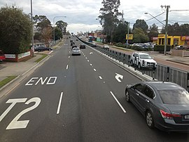
The North-West T-way is a continuous series of bus-only lanes and bus roadways between Parramatta, Blacktown and Rouse Hill in Western Sydney. Opened in stages between March and November 2007, the 24 km (14.9 mi) T-way was the second bus rapid transit route to be built in Sydney after the Liverpool-Parramatta T-way.
The Rogans Hill railway line was a short-lived railway line in the north-western suburbs of Sydney, Australia.

The James Ruse Drive is a 6.7-kilometre-long (4.2 mi) urban freeway and highway located to the east and north of Parramatta, in Western Sydney, New South Wales, Australia.
Epping Road is a 10-kilometre-long (6.2 mi) arterial road located on the North Shore of Sydney, New South Wales, Australia. Epping Road is a major route linking the lower North Shore and Sydney central business district to the north western suburbs of the upper North Shore and Hills District of metropolitan Sydney, being a major access road to the commercial, industrial and university areas of North Ryde and Macquarie Park.

The A8 is one of Sydney, Australia's metropolitan arterial routes, superseding Metroad 10. The A8 route runs for 23 kilometres from North Sydney to Mona Vale. The route includes parts of several different roads. The A8 designation replaced Metroad 10 during May 2013, much as the Metroad 10 route designation previously replaced the former State Route 14 designation in December 1998.
The Old Princes Highway is a 52-kilometre (32 mi) stretch of road, formerly designated as the Princes Highway, located in Victoria, Australia. The road links the Princes Highway at Traralgon in the east to the Geelong Ring Road at Waurn Ponds in the west, on the south-western perimeter of Geelong. In the time since their de-listing as the Princes Highway, many former sections have since been renamed, or have devolved to their original names.

Old Windsor Road is a notable road in Sydney, Australia. It starts from Kellyville, New South Wales and ends at Northmead, New South Wales. The northern end links with Windsor Road while the southern end links with Cumberland Highway and James Ruse Drive.