
Owings is a census-designated place (CDP) in Calvert County, Maryland, United States. The population was 2,149 at the 2010 census, up from 1,325 in 2000.

The trade winds or easterlies are the permanent east-to-west prevailing winds that flow in the Earth's equatorial region. The trade winds blow mainly from the northeast in the Northern Hemisphere and from the southeast in the Southern Hemisphere, strengthening during the winter and when the Arctic oscillation is in its warm phase. Trade winds have been used by captains of sailing ships to cross the world's oceans for centuries and enabled colonial expansion into the Americas and trade routes to become established across the Atlantic and Pacific oceans.
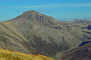
Great Gable is a mountain in the Lake District, United Kingdom. It is named for its appearance as a pyramid from Wasdale, though it is dome-shaped from most other directions. It is one of the most popular of the Lakeland fells, and there are many different routes to the summit. Great Gable is linked by the high pass of Windy Gap to its smaller sister hill, Green Gable, and by the lower pass of Beck Head to its western neighbour, Kirk Fell.
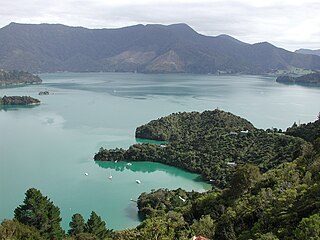
Kenepuru Sound is one of the larger of the Marlborough Sounds in the South Island of New Zealand. The drowned valley is an arm of Pelorus Sound / Te Hoiere, it runs for 25 kilometres (16 mi) from the northeast to southwest, joining Pelorus Sound a quarter of the way down the latter's path to the Cook Strait.

The Heritage Range is a major mountain range, 160 km (99 mi) long and 48 km (30 mi) wide, situated southward of Minnesota Glacier and forming the southern half of the Ellsworth Mountains in Antarctica. The range is complex, consisting of scattered ridges and peaks of moderate height, escarpments, hills and nunataks, with the various units of relief set off by numerous intervening glaciers.

The parish of Saint John is a parish of Barbados on the eastern side of the island. It is home to one of its secondary schools, The Lodge School. The parish is the home of many districts such as Ashford and Kendal. It is home to the St. John's Parish Church, which has a scenic view of the Atlantic Ocean from its perch near Hackleton's Cliff, which overlooks the East Coast of the island. In its southeastern corner, the shoreline turns northward, forming the small Conset Bay.

Windy Hill is an Australian rules football and cricket ground located in Napier Street, Essendon, a northwestern suburb of the Melbourne metropolitan area.

Formed in 1972 by voter initiative, the Midpeninsula Regional Open Space District (MROSD) is a non-enterprise special district in the San Francisco Bay Area. It has acquired and preserved a regional green belt of open space land and provides opportunities for ecologically-sensitive public enjoyment and education.
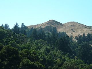
Windy Hill Open Space Preserve is a regional park located in San Mateo County, California and operated by the Midpeninsula Regional Open Space District (MROSD). It is readily identifiable from the flatlands of the South Bay, as it is the only "naked" part of the peninsula range.

Little Bowden is an area on the edge of Market Harborough, Leicestershire, England. As a village it was formerly part of Northamptonshire. The River Jordan runs through part of the area. Now, it's been integrated into Market Harborough and is fully part of the town using the town's address of 'Market Harborough'. The population is included in the civil parish of Stoke Albany.

The Willamette Valley AVA, is an American Viticultural Area which lies in the Willamette Valley of Oregon. The AVA is the wine growing region which encompasses the drainage basin of the Willamette River. It stretches from the Columbia River in the north to just south of Eugene in the south, where the Willamette Valley ends; and from the Oregon Coast Range in the west to the Cascade Mountains in the east. At 5,360 square miles (13,900 km2), it is the largest AVA in the state, and contains most of the state's wineries; approximately 200 as of 2006.

Cumberland is an edge city in Cobb County located in an unincorporated area of the northwest Atlanta metropolitan area, Georgia, United States. It is situated ten miles (16 km) northwest of downtown Atlanta. With approximately 122,000 workers and 103,000 residents, Cumberland is the region's fifth-largest business district, and is marked by several modern skyscrapers rising from the wooded hills above the freeways.

Brinscall is a village in the Borough of Chorley, Lancashire, England. Located approximately five miles north-east of Chorley, Brinscall borders the similar-sized villages of Withnell and Abbey Village. Brinscall is part of the civil parish of Withnell but does not have its own boundaries. However, an area used in the 2001 census that covers approximately the same area as the village had a population of 1,431. The village population at the 2011 census was 1,388.

Sugarloaf Hill is a 785 ft (239 m) peak along the Hudson River in Putnam County, New York, part of the Hudson Highlands. It was named by the Dutch for its resemblance in outline to a sugarloaf when sailing up the river towards it.

Kukuryak Bluff is the partly ice-free bluff rising to over 700 m at the end of a ridge descending eastwards from Louis-Philippe Plateau on Trinity Peninsula in Graham Land, Antarctica. It is surmounting Cugnot Ice Piedmont to the southeast.

The Cheviot Hills, or sometimes The Cheviots, are a range of uplands straddling the Anglo-Scottish border between Northumberland and the Scottish Borders. The English section is within the Northumberland National Park. The range includes The Cheviot, plus Hedgehope Hill to the east, Windy Gyle to the west, and Cushat Law and Bloodybush Edge to the south.

Peb Fort / Vikatgad Fort(Marathi: पेब किल्ला / विकटगड) is a fort located 19km from Karjat, in Raigad district, of Maharashtra. This fort is in continuation with the Malang gad, Tauli Hill and Chanderi fort of the Matheran Hill Range. Vikatgad is a favourite destination for one-day trekkers. The trek path to Vikatgad is along deep ravines and cliffs. Its closeness to Matheran and Neral attracts many trekkers on weekends. The forest department and local villagers are doing plantation and some restoration works on the fort.

Hony Hill is a mountain in Schoharie County, New York. It is located south-southwest of Middleburgh. Armlin Hill is located south-southwest, Cotton Hill is located northeast, Cheese Hill is located south-southwest, and Windy Ridge is located east-southeast of Hony Hill.
East Hill is a mountain in Schoharie County, New York. It is located southeast of Middleburgh. Dutton Ridge is located south-southeast and Windy Ridge is located northwest of East Hill.

