
Walton is a town in Delaware County, New York, United States. The population was 5,270 at the 2020 census. The town is in the west-central part of the county and contains the village of Walton. The town claims to be the "Scarecrow Capital of the World."

The Priestley Glacier is a major valley glacier, about 60 nautical miles long, originating at the edge of the Polar Plateau of Victoria Land, Antarctica. The glacier drains southeast between the Deep Freeze Range and Eisenhower Range to enter the northern end of the Nansen Ice Sheet. It was first explored by the Northern Party of the British Antarctic Expedition, 1910–13, and named for Raymond Priestley, a geologist with the Northern Party.
The Victory Mountains are a major group of mountains in Victoria Land, Antarctica, about 100 nautical miles long and 50 nautical miles wide, which is bounded primarily by Mariner and Tucker glaciers and the Ross Sea. They are north of the Mountaineer Range, east of the Freyberg Mountains and south of the Concord Mountains and the Admiralty Mountains. The division between the Victory Mountains and the Concord Mountains is not precise but apparently lies in the vicinity of Thomson Peak.
The Sør Rondane Mountains are a group of mountains about 100 miles (160 km) long with main peaks rising to 3400 m, between the Queen Fabiola Mountains and Wohlthat Mountains in Queen Maud Land. They were discovered and photographed from the air by members of the Lars Christensen Expedition (LCE) on February 6, 1937, and named after Rondane, a mountain massif in southern Norway. The mountains and their constituent features were mapped in greater detail and named in 1957 by Norwegian cartographers working with air photos taken by U.S. Navy Operation Highjump, 1946–47.

Annenkov Island is an island in South Georgia and the South Sandwich Islands, to the west of the main island of South Georgia. The Pickersgill Islands are to its southeast. It is irregularly shaped and 4 miles (6.4 km) long and 650 m (2,130 ft) high, lying 8 miles (13 km) off the south-central coast of South Georgia.

Besek Mountain also known as Black Mountain, est. 840 feet (260 m), is a traprock mountain ridge located 4.75 miles (7.6 km) southeast of Meriden, Connecticut. It is part of the narrow, linear Metacomet Ridge that extends from Long Island Sound near New Haven, Connecticut, north through the Connecticut River Valley of Massachusetts to the Vermont border. Besek Mountain is known for its 3-mile (4.8 km) long line of open cliffs, unique microclimate ecosystems, and rare plant communities. The mountain is traversed by the 51-mile (82 km) Mattabesett Trail, and is home to the Powder Ridge Ski Area.
Beacon Hill, (est.) 130 feet (40 m) above sea level, is a traprock outcrop located 1.2 miles (1.9 km) southeast of New Haven, Connecticut overlooking the mouth of the Farm River 1.2 miles north of Long Island Sound. It is the southernmost notable summit of the Metacomet Ridge which extends from Long Island Sound near New Haven, Connecticut, north through the Connecticut River Valley of Massachusetts to nearly the Vermont border. Beacon Hill is known for its scenic ledges overlooking a surrounding salt marsh and the greater Sound and for its unique microclimate ecosystems and rare plant communities. Beacon Hill is traversed by several trails, most notably the 28-mile (45 km) Branford Trail. The Shoreline Trolley Museum runs trolley service to the base of the hill.
Peter's Rock, also known as Rabbit Rock, Rabbit Hill, Indian Rock and Great Rock, with a high point of (est.) 373 feet (114 m) above sea level, is a trap rock peak located 4 miles (6 km) northeast of downtown New Haven, Connecticut in the town of North Haven. It is part of the Metacomet Ridge that extends from Long Island Sound near New Haven, north through the Connecticut River Valley of Massachusetts to the Vermont border. Peter's Rock is known for its scenic views, unique microclimate ecosystems, rare plant communities, and columnar basalt rock formations. It is traversed by a number of hiking trails managed by the non-profit Peter's Rock Association.

Vly Mountain is a mountain located in the town of Halcott, New York, United States in Greene County. The mountain is part of the Catskill Mountains. Vly Mountain is flanked to the northwest by Bearpen Mountain, to the east by Vinegar Hill, to the northeast by Kipp Hill, and to the southeast by Beech Ridge.

Plateau Mountain is located in the town of Hunter in Greene County, New York, United States. It is part of the Devil's Path range of the Catskill Mountains. Plateau has a two-mile-long (3.2 km) summit ridge above 3,500 feet (1,100 m). The highest point, at least 3,840 feet (1,170 m), is at the southeast end, facing Sugarloaf Mountain to the east across Mink Hollow Notch. It is the 12th-highest peak in the range Devils Tombstone is located west of Plateau Mountain. The northwest end faces Hunter Mountain to the west across 1,400-foot deep (430 m) Stony Clove Notch.
The Kyle Hills are a prominent group of volcanic cones, hills, ridges, and peaks that occupy the eastern part of Ross Island, Antarctica, between Mount Terror and Cape Crozier. The hills extend east–west for 8 nautical miles (15 km), rising from sea level at Cape Crozier to about 2,600 metres (8,500 ft) in Mount McIntosh at the western end of the group. Local relief of features is on the order of 200 metres (660 ft).
The Tomilin Glacier is a glacier over 15 nautical miles long, draining north from Pope Mountain in the central Wilson Hills. It enters the sea east of Goodman Hills and Cape Kinsey, forming a substantial glacier tongue.
Zavera Snowfield is the glacier extending 18 kilometres (11 mi) in a north-south direction and 16 kilometres (9.9 mi) in an east-west direction on southern Trinity Peninsula in Graham Land, Antarctica. It is located in the northeast foothills of Detroit Plateau, south of Diplock Glacier, north of Mount Wild and northeast of Kopito Ridge. It drains into Prince Gustav Channel in Weddell Sea. The glacier is named after the Bulgarian liberation uprising of ‘Velchova Zavera’ in 1835.
The Anticline Ridge is a ridge, southeast of Joaquin Ridge, declining from its 3,629 foot / 1,106 meter high point, Black Mountain in the north at 36°18′16″N120°24′12″W, to the southeast into low hills bound on the southeast by Los Gatos Creek that divides it from the Guijarral Hills. It is located in the inner California Coast Ranges, in Fresno County, California, east of the town of Coalinga. Anticline Ridge and Guijarral Hills divides Pleasant Valley from the San Joaquin Valley to the east. California State routes 33 and 198, which join together for the stretch through and north of Coalinga, cut across the Coalinga field and cross Anticline Ridge.
Buckskin Mountain is a 16-mile (26 km) mountain ridge that spans from Coconino County, Arizona to Kane County, Utah in the United States, that is divided almost equally between the two counties.
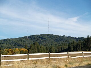
Krell Hill, also known as Tower Mountain, is a peak at the southern end of the Selkirk Mountains in Spokane County, Washington. It rises abruptly to the southeast of the relatively flat South Hill area of the city of Spokane. An area of high topographical relief continues to the east of the mountain towards Mica Peak and the Coeur d'Alene Mountains of the Bitterroot Range, in turn part of the Rocky Mountains. To the north the mountain descends slowly along a ridge, and then into the lower Dishman Hills and eventually into Spokane Valley. To the south and west the mountain towers over relatively flat terrain, with the vast farmland of the Palouse and the Columbia Plateau extending as far as the eye can see.
Ashokan Ridge is a ridge located in the Catskill Mountains of New York west of Stony Hollow. Morgan Hill is located east, and Gallis Hill is located east-southeast of Ashokan Ridge.

The Pennsylvania State Game Lands Number 49 are Pennsylvania State Game Lands in Bedford and Fulton Counties in Pennsylvania in the United States providing hunting, bird watching, and other activities.
The following is a list of neighborhoods in Wichita, Kansas, United States.

