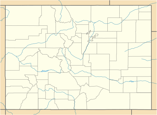
List of trading posts in Colorado

Last updated

A map of the United States when the Territory of Colorado was created on February 28, 1861. United States 1861-02-28-1861-03.png
A map of the United States when the Territory of Colorado was created on February 28, 1861.

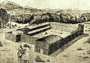
This is a partial list of trading posts that existed in the area of the present U.S. State of Colorado from 1828 to approximately 1868. The 24 historic trading posts in Colorado traded goods produced outside the region to Native Americans for furs, food, and locally made goods. Trading posts also sold goods to travellers and settlers.

Contents

Table

This is a sortable table of some of the historic trading posts in Colorado. Select the OpenStreetMap link in the box at right to view a map showing the location these trading posts.

Historic Trading Posts in Colorado

Trading postOther namesCurrent countyLocation [1] Elevation [1] EstablishedAbandonedStatus
Fort Uncompahgre Fort Robidoux Delta [lower-alpha 1] 38°45′01″N108°04′25″W / 38.7503°N 108.0737°W / 38.7503; -108.0737 (Fort Uncompahgre (historical)) [lower-alpha 2] 4,928 ft
1502 m [lower-alpha 2]
18281844Reconstruction [2]
Gantt's Picket Post Fort Gantt Bent [lower-alpha 3] 18321834No remains [3]
Bent's Fort Bent's Old Fort,
Fort William,
Bent's Picket Post
Otero [lower-alpha 4] 38°02′26″N103°25′46″W / 38.0406°N 103.4294°W / 38.0406; -103.4294 (Bent's Old Fort (historical)) 4,005 ft
1221 m
18331849 National Historic Site. [3]
Jimmy's Camp Jimmy Camp El Paso [lower-alpha 5] 18331868Nothing remains.
Fort Cass Pueblo [lower-alpha 6] 18341835No remains [3]
Fort Convenience Adams [lower-alpha 7] 18341835No remains [3]
Fort Le Duc Fort Maurice,
Buzzard's Roost,
El Cuervo
Custer [lower-alpha 8] 1830s1854No remains [3]
Fort Vasquez Weld [lower-alpha 9] 40°11′40″N104°49′16″W / 40.1944°N 104.8211°W / 40.1944; -104.8211 (Fort Vasquez (historical)) 4,826 ft
1471 m
18351842Restored and museum [3]
Fort Saint Vrain Fort George,
Fort Lookout
Weld [lower-alpha 10] 40°16′44″N104°51′18″W / 40.27889°N 104.8550°W / 40.27889; -104.8550 (Fort Saint Vrain (historical)) 4,764 ft
1452 m
18371855Historical marker [3]
Fort Lupton Fort Lawrence Weld [lower-alpha 11] 18371844Reconstructed [3]
Fort Jackson Weld [lower-alpha 12] 18371838Foundation remains [3]
Fort Gerry Weld [lower-alpha 13] late 1830s1840s [4] [5]
Milk Fort Fort Leche,
Pueblo de Leche,
Fort El Puebla,
Peebles Fort,
Fort Independence
Otero [lower-alpha 14] late 1830sNo remains [3] [4] [5]
Fort Davy Crockett Fort Misery Moffat [lower-alpha 15] 40°47′10″N108°53′40″W / 40.7862°N 108.8944°W / 40.7862; -108.8944 (Fort Davy Crockett (historical)) [lower-alpha 16] 5,374 ft
1638 m [lower-alpha 16]
late 1830s [3]
Fraeb's Post Fort Fraeb Routt [lower-alpha 17] 18401841No remains [3]
El Pueblo Fort Pueblo Pueblo [lower-alpha 18] 18421854No remains [5] [6]
Bent's New Fort Bent [lower-alpha 19] 38°05′32″N103°09′08″W / 38.0922°N 103.1522°W / 38.0922; -103.1522 (Bent's New Fort (historical)) 3,888 ft
1185 m
18531860Foundation remains [6]
Fort Namaqua Modena's Crossing,
Namaqua Station,
Mariano's Crossing,
Big Thompson,
Miraville
Larimer [lower-alpha 20] 1858 or 18591868Historical marker at Namaqua Park [6] [7] [8]
Fort Julesburg Sedgwick [lower-alpha 21] 40°56′35″N102°21′30″W / 40.9430°N 102.3582°W / 40.9430; -102.3582 (Fort Julesburg) 3,514 ft
1071 m
18601861 [9]

Maps

See also

Notes

  1. Fort Uncompahgre operated in the northwestern region of Santa Fe de Nuevo México.
  2. 1 2 This is the location of the reproduction of the trading post.
  3. Gantt's Picket Post operated in the unorganized territory of the United States.
  4. Bent's Fort operated in the unorganized territory of the United States.
  5. Jimmy's Camp operated in the unorganized territory of the United States until May 30, 1854, when the area was incorporated in the new Territory of Kansas. On January 29, 1861, the area reverted to the unorganized territory of the United States, but 30 days later the area was incorporated in the new Territory of Colorado.
  6. Fort Cass operated in the unorganized territory of the United States.
  7. Fort Convenience operated in the unorganized territory of the United States.
  8. Fort Le Duc operated in the unorganized territory of the United States until May 30, 1854, when the area was incorporated in the new Territory of Kansas.
  9. Fort Vasquez operated in the unorganized territory of the United States.
  10. Fort Saint Vrain operated in the unorganized territory of the United States until May 30, 1854, when the area was incorporated in the new Territory of Nebraska.
  11. Fort Lupton operated in the unorganized territory of the United States.
  12. Fort Jackson operated in the unorganized territory of the United States.
  13. Fort Gerry operated in the unorganized territory of the United States.
  14. Milk Fort operated in the unorganized territory of the United States.
  15. Fort Davy Crockett operated without authorization in the northwestern region of Santa Fe de Nuevo México.
  16. 1 2 This is an approximate location of the trading post.
  17. Fraeb's Post operated without authorization in the northwestern region of Santa Fe de Nuevo México.
  18. El Pueblo operated in the unorganized territory of the United States until May 30, 1854, when the area was incorporated in the new Territory of Kansas.
  19. Bent's New Fort operated in the unorganized territory of the United States until May 30, 1854, when the area was incorporated in the new Territory of Kansas.
  20. Fort Namaqua operated in Territory of Nebraska until February 28, 1861, when the area was incorporated in the new Territory of Colorado.
  21. Fort Julesburg operated in Territory of Nebraska until February 28, 1861, when the area was incorporated in the new Territory of Colorado.

Related Research Articles

<span class="mw-page-title-main">Las Animas, Colorado</span> City in Colorado, United States

Las Animas is the statutory city that is the county seat, the most populous community, and the only incorporated municipality in Bent County, Colorado, United States. The city population was 2,300 at the 2020 United States Census. Las Animas is located on the Arkansas River, just west of its confluence with the Purgatoire River, in southeast Colorado east of Pueblo, near the historic Bent's Fort.

<span class="mw-page-title-main">Fort Vasquez</span> United States historic place

Fort Vasquez is a former fur trading post 35 miles (56 km) northeast of Denver, Colorado, United States, founded by Louis Vasquez and Andrew Sublette in 1835. Restored by the Works Progress Administration in the 1930s, it now lies in a rather incongruous position as U.S. Route 85 splits to run either side of the building. History Colorado took possession of the property in 1958 and runs it as a museum to display exhibits of the fur-trade era.

<span class="mw-page-title-main">Fort Saint Vrain</span> Trading post and fort in Colorado, United States

Fort Saint Vrain was an 1837 fur trading post built by the Bent, St. Vrain Company, and located at the confluence of Saint Vrain Creek and the South Platte River, about 20 miles (32 km) east of the Rocky Mountains in the unorganized territory of the United States, in present-day Weld County, Colorado. A historical marker notes the place where Old Fort St. Vrain once stood, today at the end of Weld County Road 40, located about seven miles north of Fort Vasquez, Colorado. Among those who helped to establish the fort was Ceran St. Vrain, after whom it was named.

<span class="mw-page-title-main">Index of Colorado-related articles</span>

This is an alphabetical list of articles related to the U.S. State of Colorado.

Fort Le Duc or Fort LeDuc was a square fort and trading post built near Wetmore, Colorado. It was named after trapper Maurice LeDuc or Maurice LeDoux, and constructed around 1830 or 1835.

Fort Jackson was a fur trading post near the present-day town of Ione in Weld County, Colorado that operated from 1837 to 1838. It was one of the four trading posts along the South Platte River area. Nearby posts and competitors were Fort Vasquez, Fort Lupton, and Fort Saint Vrain.

<span class="mw-page-title-main">Fort Lupton (Colorado)</span> Trading post and fort in Colorado, United States

Fort Lupton, located in the city of the same name, was a trading post from 1836 or 1837 to 1844. After operating as a stage coach station and used as a house, the building fell into disrepair and crumbled to all but a portion of one wall by the early 20th century. The trading post has been reconstructed yards away from its original site and is now part of the South Platte Historical Park in northwestern Fort Lupton, Colorado.

Fort Namaqua, some of its other names are Mariano's Crossing and Namaqua Station, was a trading post from 1858 or 1859. It was located in the present-day city of Loveland, Colorado in Larimer County, Colorado. In 1862, it became a stage station for travelers along the foothills to Denver. A fort was built at the site after 60 horses were driven off the property. Medina also developed a small settlement with people from his hometown of Taos, New Mexico. The site was named Namaqua in 1868, with the establishment of a post office. Buildings were used until the 1920s and were later dismantled. A historical marker is located at Namaqua Park, near the site of the former fort and station. A copper sculpture honors Mariano Medina at the site of the Mariano Medina Family Cemetery.

Milk Fort, also known as Fort Leche, Pueblo de Leche, Fort El Puebla, Peebles Fort, and Fort Independence was a trading post and settlement in Otero County, Colorado in the late 1830s. There are no remains of the settlement.

<span class="mw-page-title-main">Charlotte and Dick Green</span>

Charlotte and Dick Green were enslaved African Americans who worked at Bent's Fort along the Santa Fe Trail in the southwestern frontier, in what is now Colorado. The couple and Dick's brother Andrew came to the fort with Charles and William Bent in the early 1800s and became key figures in the history of the trading post. Charlotte, also called "Black Charlotte", was known for her tasty food and fandango dancing. Dick Green was particularly well known for his role as a soldier, avenging the assassination of then Governor Charles Bent during the Taos Revolt. For his bravery, the Greens were freed and returned to Missouri.

References

  1. 1 2 "Geographic Names Information System". United States Geological Survey, United States Department of the Interior . Retrieved September 5, 2023.
  2. Jolie Anderson Gallagher (April 2, 2013). Colorado Forts: Historic Outposts on the Wild Frontier. Arcadia Publishing Incorporated. p. PT8. ISBN   978-1-61423-903-1.
  3. 1 2 3 4 5 6 7 8 9 10 11 12 Jolie Anderson Gallagher (April 2, 2013). Colorado Forts: Historic Outposts on the Wild Frontier. Arcadia Publishing Incorporated. p. PT9. ISBN   978-1-61423-903-1.
  4. 1 2 Phil Payette; Pete Payette. "Colorado forts – Fort Huerfano". American Forts Network. Retrieved June 6, 2018.
  5. 1 2 3 Glenn R. Scott (2004) [1975], "Historic Trail Maps of the Pueblo 1° x 2° Quadrangle, Colorado" (PDF), U.S. Geological Survey, Department of the Interior, pp. 4, 50
  6. 1 2 3 Jolie Anderson Gallagher (April 2, 2013). Colorado Forts: Historic Outposts on the Wild Frontier. Arcadia Publishing Incorporated. p. PT10. ISBN   978-1-61423-903-1.
  7. From the Grave: A Roadside Guide to Colorado's Pioneer Cemeteries. Caxton Press. p. 217. ISBN   978-0-87004-565-3.
  8. Jessen, Kenneth (July 26, 2014). "Spanish-Speaking Mariano Medina built a fort". Reporter-Herald. Loveland, Colorado. Retrieved June 10, 2018.
  9. Scott, Glenn R. (1989). "Historic trail maps of the Sterling 1 degree by 2 degrees Quadrangle, northeastern Colorado". United States Department of the Interior, United States Geological Survey. doi:10.3133/i1894 . Retrieved July 23, 2021.

38°59′50″N105°32′52″W / 38.9972°N 105.5478°W / 38.9972; -105.5478 (State of Colorado)