National Register of Historic Places listings in Adams County, Colorado

Last updated
Location of Adams County in Colorado Map of Colorado highlighting Adams County.svg
Location of Adams County in Colorado

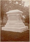
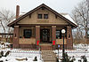
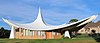
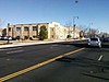
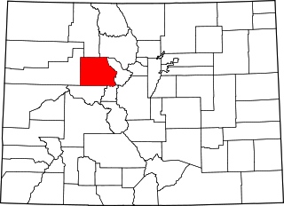
This is a list of the National Register of Historic Places listings in Adams County, Colorado.

Contents

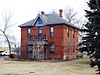
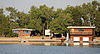
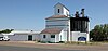
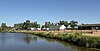
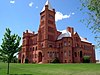
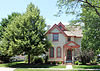
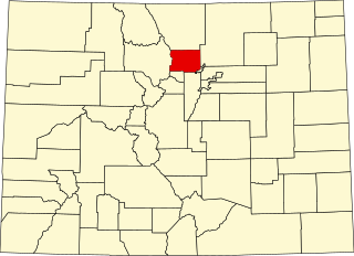
This is intended to be a complete list of the properties and districts on the National Register of Historic Places in Adams County, Colorado, United States. The locations of National Register properties and districts for which the latitude and longitude coordinates are included below, may be seen in a map. [1]

There are 20 properties and districts listed on the National Register in the county. Another property was once listed but has been removed.


    This National Park Service list is complete through NPS recent listings posted November 24, 2023. [2]

Contents: Counties in Colorado
Adams - Alamosa - Arapahoe - Archuleta - Baca - Bent - Boulder - Broomfield - Chaffee - Cheyenne - Clear Creek - Conejos - Costilla - Crowley - Custer - Delta - Denver - Dolores - Douglas - Eagle - El Paso - Elbert - Fremont - Garfield - Gilpin - Grand - Gunnison - Hinsdale - Huerfano - Jackson - Jefferson - Kiowa - Kit Carson - La Plata - Lake - Larimer - Las Animas - Lincoln - Logan - Mesa - Mineral - Moffat - Montezuma - Montrose - Morgan - Otero - Ouray - Park - Phillips - Pitkin - Prowers - Pueblo - Rio Blanco - Rio Grande - Routt - Saguache - San Juan - San Miguel - Sedgwick - Summit - Teller - Washington - Weld - Yuma
Map all coordinates using: OpenStreetMap

Current listings

[3] Name on the Register [4] ImageDate listed [5] Location City or townDescription
1 Adams County Courthouse
Adams County Courthouse AdamsCountyCourthouse.JPG
Adams County Courthouse
October 4, 2006
(#06000916)
22 S. 4th Ave.
39°59′11″N104°49′02″W / 39.986389°N 104.817222°W / 39.986389; -104.817222 (Adams County Courthouse)
Brighton
2 Bowles House
Bowles House BowlesHouse.JPG
Bowles House
November 3, 1988
(#88002308)
3924 W. 72nd Ave.
39°49′38″N105°02′17″W / 39.827222°N 105.038056°W / 39.827222; -105.038056 (Bowles House)
Westminster
3 Brannan Sand and Gravel Pit No. 8-Lake Sangraco Boathouse Complex
Brannan Sand and Gravel Pit No. 8-Lake Sangraco Boathouse Complex Brannan Sand and Gravel Pit No. 8-Lake Sangraco Boathouse Complex.JPG
Brannan Sand and Gravel Pit No. 8-Lake Sangraco Boathouse Complex
August 16, 2011
(#11000519)
Off Lowell Boulevard south of 62nd Ave. [6]
39°48′22″N105°01′56″W / 39.806111°N 105.032222°W / 39.806111; -105.032222 (Brannan Sand and Gravel Pit No. 8-Lake Sangraco Boathouse Complex)
Berkley
4 Brighton High School
Brighton High School BrightonHighSchool.JPG
Brighton High School
January 23, 1998
(#97001665)
830 E. Bridge St.
39°59′09″N104°48′40″W / 39.985833°N 104.811111°W / 39.985833; -104.811111 (Brighton High School)
Brighton
5 Bromley Farm-Koizuma Hishinuma Farm
Bromley Farm-Koizuma Hishinuma Farm BromleyFarm-KoizumaHishinumaFarm.JPG
Bromley Farm-Koizuma Hishinuma Farm
August 16, 2007
(#07000811)
15820 E. 152nd Ave.
39°58′17″N104°48′05″W / 39.971389°N 104.801389°W / 39.971389; -104.801389 (Bromley Farm-Koizuma Hishinuma Farm)
Brighton
6 Colorado Sanitary Canning Factory
Colorado Sanitary Canning Factory Colorado Sanitary Canning Factory.JPG
Colorado Sanitary Canning Factory
March 15, 2016
(#16000073)
224 N. Main St.
39°59′24″N104°49′14″W / 39.990061°N 104.820474°W / 39.990061; -104.820474 (Colorado Sanitary Canning Factory)
Brighton
7 Deza Estates November 24, 2023
(#100009565)
W. 99th Ave, Lunceford Lane, Palmer Lane, Rapp Lane
39°52′29″N104°59′57″W / 39.8748°N 104.9992°W / 39.8748; -104.9992 (Deza Estates)
Northglenn
8 Eastlake Farmers Co-Operative Elevator Company
Eastlake Farmers Co-Operative Elevator Company Eastlake Farmers Co-Operative Elevator Company.JPG
Eastlake Farmers Co-Operative Elevator Company
May 17, 2010
(#10000259)
126th Ave and Claude Ct.
39°55′31″N104°57′51″W / 39.925278°N 104.964264°W / 39.925278; -104.964264 (Eastlake Farmers Co-Operative Elevator Company)
Thornton
9 Engelbrecht Farm December 10, 2014
(#14000170)
2024 Strasburg Rd.
39°44′47″N104°19′20″W / 39.7465°N 104.3223°W / 39.7465; -104.3223 (Engelbrecht Farm)
Strasburg
10 Granville Fuller House
Granville Fuller House Granville Fuller House.JPG
Granville Fuller House
May 1, 2012
(#12000242)
2027 Galena St.
39°44′53″N104°52′11″W / 39.748056°N 104.869696°W / 39.748056; -104.869696 (Granville Fuller House)
Aurora
11 William J. Gregory House
William J. Gregory House William J. Gregory House.jpg
William J. Gregory House
February 23, 1996
(#96000166)
8140 Lowell Boulevard
39°50′40″N105°02′01″W / 39.844444°N 105.033611°W / 39.844444; -105.033611 (William J. Gregory House)
Westminster
12 Harris Park School
Harris Park School Harris Park School.JPG
Harris Park School
August 30, 1990
(#90000868)
7200 Lowell Boulevard
39°49′40″N105°02′00″W / 39.827778°N 105.033333°W / 39.827778; -105.033333 (Harris Park School)
Westminster
13 Metzger Farm
Metzger Farm Metzger Farm.JPG
Metzger Farm
March 20, 2013
(#13000077)
12080 Lowell Blvd.
39°55′01″N105°01′51″W / 39.917077°N 105.03091°W / 39.917077; -105.03091 (Metzger Farm)
Westminster
14 Riverside Cemetery
Riverside Cemetery JohnEvansGraveRiversideCemetery.jpg
Riverside Cemetery
October 28, 1994
(#94001253)
5201 Brighton Boulevard
39°47′39″N104°57′33″W / 39.794167°N 104.959167°W / 39.794167; -104.959167 (Riverside Cemetery)
Commerce City Extends into Denver
15 M.J. Lavina Robidoux House
M.J. Lavina Robidoux House M.J. Lavina Robidoux House.JPG
M.J. Lavina Robidoux House
September 15, 2011
(#11000655)
1615 Galena St.
39°44′32″N104°52′11″W / 39.742333°N 104.869722°W / 39.742333; -104.869722 (M.J. Lavina Robidoux House)
Aurora
16 St. Stephen's Lutheran Church
St. Stephen's Lutheran Church St. Stephen's Lutheran Church.JPG
St. Stephen's Lutheran Church
July 12, 2019
(#100004209)
10828 Huron St.
39°53′34″N104°59′48″W / 39.8929°N 104.9967°W / 39.8929; -104.9967 (St. Stephen's Lutheran Church)
Northglenn
17 Thede Farmhouse
Thede Farmhouse ThedeFarmHouse.JPG
Thede Farmhouse
January 30, 1998
(#98000024)
3190 E. 112th Ave.
39°53′42″N104°57′04″W / 39.895°N 104.951111°W / 39.895; -104.951111 (Thede Farmhouse)
Northglenn
18 Union High School
Union High School UNION HIGH SCHOOL.JPG
Union High School
January 14, 2000
(#99001665)
3455 W. 72nd Ave.
39°49′40″N105°01′56″W / 39.827778°N 105.032222°W / 39.827778; -105.032222 (Union High School)
Westminster
19 Westminster University
Westminster University Westminster Castle in Colorado.JPG
Westminster University
August 10, 1979
(#79000572)
3455 W. 83rd Ave.
39°50′50″N105°01′53″W / 39.847222°N 105.031389°W / 39.847222; -105.031389 (Westminster University)
Westminster Red sandstone college building designed by E.B. Gregory and Stanford White. See also Westminster University
20 Blanche A. Wilson House
Blanche A. Wilson House Blanche A Wilson House.JPG
Blanche A. Wilson House
November 7, 1996
(#96001278)
1671 Galena St.
39°44′38″N104°52′09″W / 39.743889°N 104.869167°W / 39.743889; -104.869167 (Blanche A. Wilson House)
Aurora

Former listing

[3] Name on the RegisterImageDate listedDate removedLocationCity or townDescription
1 David Wolpert House June 27, 1975
(#75002141)
December 9, 19759190 River Dale Rd.
Thornton Destroyed by fire in 1976 [7]

See also

Related Research Articles

<span class="mw-page-title-main">National Register of Historic Places listings in Boulder County, Colorado</span> List of National Register of Historic Places in Boulder County, Colorado, United States

This is a list of the National Register of Historic Places listings in Boulder County, Colorado.

<span class="mw-page-title-main">National Register of Historic Places listings in El Paso County, Colorado</span> List of National Register of Historic Places in El Paso County, Colorado, United States

This is a list of the National Register of Historic Places listings in El Paso County, Colorado.

<span class="mw-page-title-main">National Register of Historic Places listings in Jefferson County, Colorado</span> List of National Register of Historic Places in Jefferson County, Colorado, United States

This is a list of the National Register of Historic Places listings in Jefferson County, Colorado.

<span class="mw-page-title-main">National Register of Historic Places listings in Pueblo County, Colorado</span> List of National Register of Historic Places in Pueblo County, Colorado, United States

This is a list of the National Register of Historic Places listings in Pueblo County, Colorado, USA.

<span class="mw-page-title-main">National Register of Historic Places listings in Weld County, Colorado</span> List of National Register of Historic Places in Weld County, Colorado, United States

This is a list of the National Register of Historic Places listings in Weld County, Colorado.

<span class="mw-page-title-main">National Register of Historic Places listings in Clear Creek County, Colorado</span> List of National Register of Historic Places in Clear Creek County, Colorado, United States

This is a list of the National Register of Historic Places listings in Clear Creek County, Colorado.

<span class="mw-page-title-main">National Register of Historic Places listings in Douglas County, Colorado</span> List of National Register of Historic Places in Douglas County, Colorado, United States

This is a list of the National Register of Historic Places listings in Douglas County, Colorado.

<span class="mw-page-title-main">National Register of Historic Places listings in Mesa County, Colorado</span> List of National Register of Historic Places in Mesa County, Colorado, United States

This is a list of the National Register of Historic Places listings in Mesa County, Colorado.

<span class="mw-page-title-main">National Register of Historic Places listings in Las Animas County, Colorado</span> List of National Register of Historic Places in Las Animas County, Colorado, United States

This is a list of the National Register of Historic Places listings in Las Animas County, Colorado.

<span class="mw-page-title-main">National Register of Historic Places listings in Arapahoe County, Colorado</span> List of National Register of Historic Places in Arapahoe County, Colorado, United States

This is a list of the National Register of Historic Places listings in Arapahoe County, Colorado.

<span class="mw-page-title-main">National Register of Historic Places listings in Park County, Colorado</span> List of National Register of Historic Places in Park County, Colorado, United States

This is a list of the National Register of Historic Places listings in Park County, Colorado.

<span class="mw-page-title-main">National Register of Historic Places listings in Garfield County, Colorado</span> List of National Register of Historic Places in Garfield County, Colorado, United States

This is a list of the National Register of Historic Places listings in Garfield County, Colorado.

<span class="mw-page-title-main">National Register of Historic Places listings in Eagle County, Colorado</span> List of National Register of Historic Places in Eagle County, Colorado, United States

This is a list of the National Register of Historic Places listings in Eagle County, Colorado.

<span class="mw-page-title-main">National Register of Historic Places listings in Rio Blanco County, Colorado</span> List of National Register of Historic Places in Rio Blanco County, Colorado, United States

This is a list of the National Register of Historic Places listings in Rio Blanco County, Colorado.

<span class="mw-page-title-main">National Register of Historic Places listings in northeast Denver</span> List of National Register of Historic Places in northeast Denver, Colorado, United States

This is a list of the National Register of Historic Places listings in Northeast Denver, Colorado.

<span class="mw-page-title-main">National Register of Historic Places listings in southeast Denver</span> List of National Register of Historic Places in southeast Denver, Colorado, United States

This is a list of the National Register of Historic Places listings in Southeast Denver, Colorado.

<span class="mw-page-title-main">National Register of Historic Places listings in west Denver</span> List of National Register of Historic Places in west Denver, Colorado, United States

This is a list of the National Register of Historic Places listings in West Denver, Colorado.

<span class="mw-page-title-main">National Register of Historic Places listings in downtown Denver</span> List of National Register of Historic Places in downtown Denver, Colorado, United States

This is a list of the National Register of Historic Places listings in Downtown Denver, Colorado.

<span class="mw-page-title-main">National Register of Historic Places listings in Conejos County, Colorado</span> List of National Register of Historic Places in Conejos County, Colorado, United States

This is a list of the National Register of Historic Places listings in Conejos County, Colorado.

<span class="mw-page-title-main">National Register of Historic Places listings in Summit County, Colorado</span> List of National Register of Historic Places in Summit County, Colorado, United States

This is a list of the National Register of Historic Places listings in Summit County, Colorado.

References

  1. The latitude and longitude information provided in this table was derived originally from the National Register Information System, which has been found to be fairly accurate for about 99% of listings. Some locations in this table may have been corrected to current GPS standards.
  2. National Park Service, United States Department of the Interior, "National Register of Historic Places: Weekly List Actions", retrieved November 24, 2023.
  3. 1 2 Numbers represent an alphabetical ordering by significant words. Various colorings, defined here, differentiate National Historic Landmarks and historic districts from other NRHP buildings, structures, sites or objects.
  4. "National Register Information System". National Register of Historic Places . National Park Service. July 9, 2010.
  5. The eight-digit number below each date is the number assigned to each location in the National Register Information System database, which can be viewed by clicking the number.
  6. Location derived from its GNIS feature record; the NRIS lists the site as "Address Restricted".
  7. "Colorado Office of Archaeology and Historic Preservation | Properties removed from the National and State Registers". Archived from the original on 2012-08-18. Retrieved 2012-08-17.

39°52′27″N104°20′16″W / 39.8742°N 104.3378°W / 39.8742; -104.3378 (Adams County, Colorado)