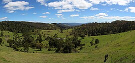
The Lamington National Park is a national park, lying on the Lamington Plateau of the McPherson Range on the Queensland/New South Wales border in Australia. From Southport on the Gold Coast the park is 85 kilometres (53 mi) to the southwest and Brisbane is 110 kilometres (68 mi) north. The 20,600 hectares Lamington National Park is known for its natural environment, rainforests, birdlife, ancient trees, waterfalls, walking tracks and mountain views.

The Albert River is a perennial river located in the South East region of Queensland, Australia. Its catchment lies within the Gold Coast and Scenic Rim Region local government areas and covers an area of 782 square kilometres (302 sq mi). The river provides potable water for the town of Beaudesert.

Natural Bridge is a rural locality in the City of Gold Coast, Queensland, Australia. It borders New South Wales. In the 2016 census, Natural Bridge had a population of 108 people.

Binna Burra is a parcel of private land and mountain lodge within the locality of Binna Burra and surrounded by Lamington National Park in Queensland, Australia. It is also a locality in the Scenic Rim Region. The lodge lies in the north-eastern corner of the Lamington Plateau in the McPherson Range, 75 kilometres (47 mi) south of Brisbane in the scenic rim hinterland of the Gold Coast. It's about 30 minute drive up the mountain from Nerang and a similar distance from Canungra. It is marketed as an ecolodge and was one of the first nature based resorts to be established in Australia. In 2000, the resort was the first commercial accommodation provider to be awarded Green Globe Certification in Australia. The lodge and other aspects of the built environment at Binna Burra are listed on the Queensland Heritage Register as the Binna Burra Cultural Landscape. In September 2019, the area was devastated by bushfires and the historic lodge was destroyed. After one year of closure, the Binna Burra side of Lamington National Park reopened to the public in September 2020.

Canungra is a small rural town and locality in the Scenic Rim Region, Queensland, Australia. At the 2016 census, Canungra had a population of 1,229.

Tamborine Mountain is a 28 km2 (11 sq mi) plateau and locality in the Scenic Rim Region of South East Queensland, Australia. The name is of Aboriginal origin and is frequently misspelt as Tambourine but neither the name nor the place has any connection to the musical instrument. It is considered part of the Gold Coast hinterland and has a strong tourist industry.

The Scenic Rim is a group of forested mountain ranges of the Great Dividing Range, located south of Brisbane agglomeration, straddling the border between south-eastern Queensland and north-eastern New South Wales, Australia.

Numinbah Valley is a rural locality in the City of Gold Coast, Queensland, Australia. In the 2016 census, Numinbah Valley had a population of 218 people.

The Scenic Rim Region is a local government area in West Moreton region of South East Queensland, Australia. Established in 2008, it was preceded by several previous local government areas with histories extending back to the early 1900s and beyond. The main town of the region is Beaudesert.
Beechmont is a rural town and locality in the Scenic Rim Region, Queensland, Australia. In the 2016 census, Beechmont had a population of 842 people.

The Gold Coast hinterland is an area of South East Queensland, Australia that comprises the Tweed Range, Nimmel Range, Tamborine Mountain, Numinbah Valley, eastern parts of the McPherson Range and western parts of suburban Gold Coast, such as Mudgeeraba. This undefined unit of area is known for its tourist attractions including resorts, rainforest, lookouts, national parks, its diversity of fauna and flora and as a green backdrop to the coastal strip. It overlaps part of the Scenic Rim and is part of both the City of Gold Coast and Scenic Rim Region and includes Springbrook, Binna Burra and O'Reilly.
Springbrook is a mountain and plateau in the Gold Coast hinterland of South East Queensland, Australia. It is also the name of the associated town and locality within the City of Gold Coast. It borders New South Wales.

O'Reilly's Rainforest Retreat is a tourist destination in the locality of O'Reilly, Scenic Rim Region, Queensland, Australia. It is situated in the heart of the Lamington National Park, two hours by road south of Brisbane and 90 minutes by road west of the Gold Coast. Access to the mountain resort is via Canungra.
Wonglepong is a rural locality in the Scenic Rim Region of Queensland, Australia.

Boyland is a locality in the Scenic Rim Region, Queensland, Australia. At the 2016 Australian Census, the locality recorded a population of 823.

Tamborine is a town in the Scenic Rim Region and a locality split between the Scenic Rim Region and the City of Logan in Queensland, Australia. The neighbourhood of Plunkett is within the locality.
Binna Burra is a rural locality in the Scenic Rim Region, Queensland, Australia. It borders New South Wales. In the 2016 census, Binna Burra had a population of 4 people.

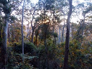
Nugurun Falls is a small waterfall on West Canungra Creek, a tributary of the Logan River, in Queensland, Australia. The waterfall is located within the Green Mountains section of Lamington National Park, in the Scenic Rim Region, near the resort village of O'reillys. Like other waterfalls in the area, Nugurun Falls is surrounded by dense rainforest.

Lamington is a rural locality in the Scenic Rim Region, Queensland, Australia. In the 2016 census, Lamington and surrounding localities had a population of 86 people.

Southern Lamington is a rural locality in the Scenic Rim Region, Queensland, Australia. It borders New South Wales. In the 2016 census, Southern Lamington had no population.