1767 Milestones | |
 The "Parting Ways" stone in Roxbury | |
   | |
| Location | Massachusetts between Springfield and Boston |
|---|---|
| Area | less than one acre |
| Built | various dates; many pursuant to a policy dating to 1767 |
| NRHP reference No. | 71000084, 85003300 [1] [2] |
| Added to NRHP | April 7, 1971 |
The 1767 Milestones are historic milestones located along the route of the Upper Boston Post Road between the cities of Boston and Springfield in Massachusetts. The 40 surviving milestones were added to the National Register of Historic Places in 1971. [1] Massachusetts has a total of 129 surviving milestones including those along the upper Post Road. [3] The stones are so named, despite having been placed in many different years, because of a 1767 directive of the Province of Massachusetts Bay that such stones be placed along major roadways. The state highway department was directed in 1960 to undertake their preservation. [4] Many of them underwent a major restoration in 2018. [5]
The first stone was erected by Paul Dudley, one of the prominent citizens of early 18th century Massachusetts, in Roxbury, which was at the time a separate community. Roxbury was located at the end of the Boston Neck, a narrow isthmus separating the mainland from the Shawmut Peninsula, where Boston was located. Travelers going by land from Boston to other areas had to travel over the neck and through Roxbury to reach their destinations. The Roxbury junction where Dudley placed the first stone was where several routes branched, heading south and west across New England.
Dudley erected several stones along the road from Boston to Cambridge which wound its way from Beacon Hill along what is now Washington Street through the Dudley Square area to what is now Huntington Avenue, then along Harvard Street through Brookline Village, Coolidge Corner, and Allston crossing into Cambridge at the Great Bridge, where modern JFK Street in Cambridge becomes North Harvard Street in Allston. The stones that Dudley erected have the initials PD on them, usually at the bottom of the stone. [6] The most chatty of these milestones (not part of this collection), is inscribed P Dudley rather than PD, and is located on the corner of Centre and South Streets in Jamaica Plain.
The stones listed for miles 23 through 29 in Wayland and Sudbury are actually guideposts rather than milestones, and do not list any mileage. They were erected at road intersections rather than at the mile marks. The stones are quarried granite posts with plug & feather tool marks and post-date 1800.
| Miles to Boston | Year Placed | Image | Location | Town | Notes |
|---|---|---|---|---|---|
| 01 | 1741 |  | Centre and Roxbury Streets | Boston, Roxbury | This stone is called the "Parting Ways Stone". |
| 04 | 1729 |  | 841 Huntington Avenue | Boston, Mission Hill | Engraved "Boston 4 Miles 1729 PD". |
| 05 | 1729 |  | 210 Harvard St. | Brookline | Engraved "Boston 5 Miles 1729 PD". |
| 06 | 1729 |  | 142 Harvard Ave. | Boston, Brighton | Engraved "Boston 6 Miles 1729 PD". |
| 07 | 1729 | 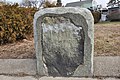 | 240 N. Harvard St. | Boston, Brighton | Engraved "Boston 7 Miles 1729 PD". |
| 08 | 1734 |  | Old Burial Ground (Mass. Ave. and Garden St.) | Cambridge | Engraved "Boston 8 Miles 1734 AI" on the front, and "Cambridge New Bridge +2⁄1 Miles 1794" on the back. |
| 23 |  | River Road and Water Row | Wayland | ||
| 24 |  | Route 20 and Landham Road | Sudbury | ||
| 25 |  | Route 20 and Concord Road | Sudbury | ||
| 26 |  | Route 20 and Nobscot Road | Sudbury | ||
| 27 | listed at Boston Post Road and Dudley Road | Sudbury | Listed as missing in 2009 state survey. | ||
| 28 |  | Route 20 and Peakham Road | Sudbury | ||
| 29 |  | Wayside Inn Road and Dutton Road | Sudbury | ||
| 33 |  | 143 E. Main St. | Northborough | Engraved "33 Miles to Boston". | |
| 35 |  | Boston Post Road and Dean Park | Shrewsbury | Engraved "Boston 35 Springfield 65 Albany 165". | |
| 43 | c.1760 |  | West Main St. Near town common | Shrewsbury | Engraved "43 Mile to Boston". |
| 47 |  | Lincoln St. | Worcester | ||
| 48 | Originally at 139 Salisbury St. | Worcester | Moved to 30 Elm Street (Worcester Historical Museum) c. 2007 It was reported to be in storage there in January 2014. | ||
| 53 | 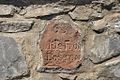 | Route 9 at Collier's Corner | Leicester | ||
| 54 |  | Originally at Main St. east of Paxton St. | Leicester | Stolen and recovered in the 1990s; relocated to museum space in local library in 1996. Now on the Leicester town common. An unmarked replica is embedded in a stone wall just west of Paxton on the south side of Main Street. | |
| 56 |  | Between 1676 and 1710 Main St. (Route 9) | Leicester | Opposite Leicester Drive-In. | |
| 57 | 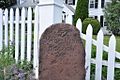 | 500 Main St. (Route 9) | Leicester | In front of the Spencer Country Inn. | |
| 58 |  | 325 Main St. (Route 9) | Spencer | ||
| 59 |  | Route 9, Spencer Shopper's Village | Spencer | ||
| 60 | 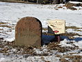 | Route 9 at Dewey St. | Spencer | ||
| 61 | 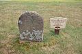 | 133 West Main St. (Route 9) | Spencer | ||
| 62 |  | west of 324 East Main St. (Route 9) | East Brookfield | Stone has been reengraved with loss of integrity. | |
| 63 |  | 184 North Brookfield Rd. | East Brookfield | ||
| 64 |  | Elm Hill Rd., near North Brookfield line | Brookfield | ||
| 65 |  | Elm Hill Rd., east of North Brookfield Rd. | Brookfield | ||
| 66 |  | East of 31 West Main St. (Route 9) | Brookfield | ||
| 67 |  | 102 Foster Hill Rd. | West Brookfield | ||
| 68 |  | East end of town common | West Brookfield | ||
| 69 |  | 147 West Main St. (Route 9) | West Brookfield | ||
| 70 |  | Route 67 near Old Patrick Rd. | Warren | ||
| 71 |  | Burbank and Washington Sts. (behind/north side of 129 Washington St.) | Warren | ||
| 72 |  | Bemis and Washington Rds. | Warren | Now in front of Warren Congregational Church; relocated after 1970. | |
| 73 |  | North side of Baypath Rd. | Warren | ||
| 74 |  | 970 Read St., east of West Warren Rd. | Warren | ||
| 99 | 1763 |  | State St. at Federal St. (Springfield Armory) | Springfield | Known as the "Wait Guide Stone". Inscribed-
Replica placed in 2010. [7] Original in storage at the Armory Museum. |
| Source unless otherwise cited: NRHP nomination papers [4] | |||||
