Abel Janszoon Tasman was a Dutch seafarer and explorer, best known for his voyages of 1642 and 1644 in the service of the Dutch East India Company (VOC).
Van Diemen's Land was the colonial name of the island of Tasmania used by the British during the European exploration and colonisation of Australia in the 19th century. The island was previously discovered and named by the Dutch in 1642. Explorer Abel Tasman discovered the island, working under the sponsorship of Anthony van Diemen, the Governor-General of the Dutch East Indies. The British retained the name when they established a settlement in 1803 before it became a separate colony in 1825. Its penal colonies became notorious destinations for the transportation of convicts due to the harsh environment, isolation and reputation for being inescapable.

The maritime European exploration of Australia consisted of several waves of European seafarers who sailed the edges of the Australian continent. Dutch navigators were the first Europeans known to have explored and mapped the Australian coastline. The first documented encounter was that of Dutch navigator Willem Janszoon, in 1606. Dutch seafarers also visited the west and north coasts of the continent, as did French explorers.

HMS Endeavour was a British Royal Navy research vessel that Lieutenant James Cook commanded to Tahiti, New Zealand and Australia on his first voyage of discovery from 1768 to 1771.

Bruny Island is a 362-square-kilometre (140 sq mi) island located off the southeastern coast of Tasmania, Australia. The island is separated from the Tasmanian mainland by the D'Entrecasteaux Channel, and its east coast lies within the Tasman Sea. Located to the island's northeast Storm Bay, is the river mouth to the Derwent River estuary, and serves as the main port of Hobart, Tasmania's capital city. Both the island and the channel are named after French explorer, Antoine Bruni d'Entrecasteaux. Its traditional Aboriginal name is lunawanna-allonah, which survives as the name of two island settlements, Alonnah and Lunawanna.

St Helens is the largest town on the north-east coast of Tasmania, Australia, on Georges Bay. It is known as the game fishing capital of Tasmania and is also renowned for its oysters. It is located on the Tasman Highway, about 160 km east of Tasmania's second largest city, Launceston. In the early 2000s, the town was one of the fastest growing areas of Tasmania, and reached a population of 2049 at the 2006 census. By the time of the 2021 census, it had a population of 2,206.

Captain Tobias Furneaux was a British navigator and Royal Navy officer, who accompanied James Cook on his second voyage of exploration. He was one of the first men to circumnavigate the world in both directions, and later commanded a British vessel during the American War of Independence.
HMS Adventure was a barque that the Royal Navy purchased in 1771. She had been the merchant vessel Marquis of Rockingham, launched in 1770 at Whitby. In naval service she sailed with Resolution on James Cook's second expedition to the Pacific in 1772–1775. She was the first ship to circumnavigate the globe from west to east. After her return she served as a store ship until 1779. The navy sold her in 1783 and she resumed a civilian career, but retaining the name Adventure. She was lost in May 1811.
Eden is a coastal town in the South Coast region of New South Wales, Australia. The town is 478 kilometres (297 mi) south of the state capital Sydney and is the most southerly town in New South Wales, located between Nullica Bay to the south and Calle Calle Bay, the northern reach of Twofold Bay, and built on undulating land adjacent to the third-deepest natural harbour in the southern hemisphere, and Snug Cove on its western boundary. At the 2016 census, Eden had a population of 3,151.
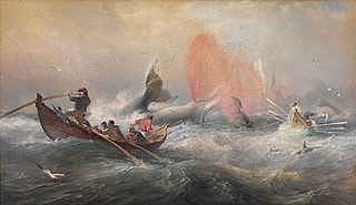
Whaling in Australian waters began in 1791 when five of the 11 ships in the Third Fleet landed their passengers and freight at Sydney Cove and then left Port Jackson to engage in whaling and seal hunting off the coast of Australia and New Zealand. The two main species hunted by such vessels in the early years were right and sperm whales. Humpback, bowhead and other whale species would later be taken.

The D'Entrecasteaux Channel is a body of water located between Bruny Island and the south-east of the mainland of Tasmania, Australia. The channel is the mouth for the estuaries of the Derwent and the Huon Rivers and empties into the Tasman Sea of the South Pacific Ocean. It was sighted by Abel Tasman in 1642 and surveyed in 1792 by Bruni d'Entrecasteaux.
Frederick Henry Bay is a body of water in the southeast of Tasmania, Australia. It is located to the east of the South Arm Peninsula, and west of the Tasman Peninsula. Towns on the coast of the bay include Lauderdale, Seven Mile Beach, Dodges Ferry and Primrose Sands. The bay is accessible via Storm Bay from the south, and provides further access to Norfolk Bay to its east.
Bahía Buen Suceso is a small bay in Argentina's Tierra del Fuego province. It is known in English as Bay of Good Success, Bay of Success and Success Bay. It is located on the western shore of Le Maire Strait, which separates Tierra del Fuego and Isla de los Estados.
The first humans are thought to have arrived in New Zealand from Polynesia some time around 1300 AD. The people, who later became known as Māori, eventually travelled to almost every part of the country. Their arrival had a significant impact on the local fauna, particularly the flightless birds such as moa.
Abraham Bristow (c1771-1846) was a British mariner, sealer and whaler. In August 1806 he discovered the Auckland Islands.

The second voyage of James Cook, from 1772 to 1775, commissioned by the British government with advice from the Royal Society, was designed to circumnavigate the globe as far south as possible to finally determine whether there was any great southern landmass, or Terra Australis. On his first voyage, Cook had demonstrated by circumnavigating New Zealand that it was not attached to a larger landmass to the south, and he charted almost the entire eastern coastline of Australia, yet Terra Australis was believed to lie further south. Alexander Dalrymple and others of the Royal Society still believed that this massive southern continent should exist. After a delay brought about by the botanist Joseph Banks' unreasonable demands, the ships Resolution and Adventure were fitted for the voyage and set sail for the Antarctic in July 1772.
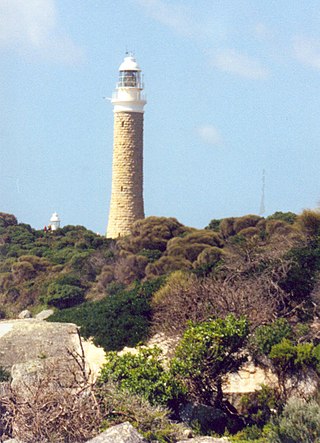
Eddystone Point lies on the north-east coast of Tasmania, Australia at 40.994 S/148.349 E.
Rambler was launched in America in 1812. The British captured her in 1813 as she was returning to America from Manila. She then briefly became a West Indiaman. In 1815 she became a whaler in the Southern Fishery. She made four complete whaling voyages and was wrecked on her fifth.
Resolution was launched at Liverpool in 1776 as the West Indiaman Thomas Hall; she was renamed in 1779. She sailed briefly as a privateer. Then between 1791 and 1804 Revolution made some six voyages as a whaler. On one voyage, in 1793, a French frigate captured her, but Resolution was re-captured. In 1804 a new owner returned her to the West Indies trade. She does not appear to have sailed after early 1805.


