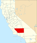
Alta Sierra, Kern County, California

Last updated

Alta Sierra
California Locator Map with US.PNG
Red pog.svg
Alta Sierra
Location in California
Usa edcp location map.svg
Red pog.svg
Alta Sierra
Alta Sierra (the United States)
Coordinates: 35°43′45″N118°32′58″W / 35.72917°N 118.54944°W / 35.72917; -118.54944
Country United States
State California
County Kern County
Area
[1]
  Total1.0 sq mi (2.6 km2)
  Land1.0 sq mi (2.6 km2)
  Water0 sq mi (0 km2)
Elevation
[2]
5,718 ft (1,743 m)
Population
 (2020) [3]
  Total103
  Density100/sq mi (40/km2)

Alta Sierra is an unincorporated community in Kern County, California. [2]

It is located 8.5 miles (14 km) east of Glennville, [4] at an elevation of 5,718 feet (1,743 m) in the Greenhorn Mountains/Sierra Nevada foothills. [2] For statistical purposes, the United States Census Bureau has defined Alta Sierra as a census-designated place (CDP).

Related Research Articles

<span class="mw-page-title-main">Madera County, California</span> County in California, United States

Madera County, officially the County of Madera, is located at the geographic center of the U.S. state of California. It features a varied landscape, encompassing the eastern San Joaquin Valley and the central Sierra Nevada, with Madera serving as the county seat. Established in 1893 from part of Fresno County, Madera County reported a population of 156,255 in the 2020 census.

<span class="mw-page-title-main">Bodfish, California</span> Census-designated place in California, United States

Bodfish is a census-designated place (CDP) in the southern Kern River Valley of the Southern Sierra Nevada, in Kern County, California.

<span class="mw-page-title-main">Kernville, California</span> Census-designated place in California, United States

Kernville is a census-designated place (CDP) in the southern Sierra Nevada, in Kern County, California, United States. Kernville is located 42 miles (68 km) northeast of Bakersfield, at an elevation of 2,667 feet (813 m). The population was 1,549 at the 2020 United States census, up from 1,395 at the 2010 census, but below the 2000 census total of 1,736.

<span class="mw-page-title-main">Lake Isabella, California</span> Census-designated place in California, United States

Lake Isabella is a census-designated place (CDP) in the southern Sierra Nevada, in Kern County, California, United States. It is named after the Lake Isabella reservoir and located at its southwestern edge, 6 miles (9.7 km) south of Wofford Heights in the Kern River Valley.

<span class="mw-page-title-main">Weedpatch, California</span> Census-designated place in California, United States

Weedpatch is an unincorporated community and census-designated place (CDP) in Kern County, California, United States. Weedpatch is 10 miles (16 km) south-southeast of Bakersfield. It is considered to be one of the poorest areas in Kern County. As of the 2010 census it had a population of 2,658.

<span class="mw-page-title-main">Wofford Heights, California</span> Census-designated place in California, United States

Wofford Heights is a census-designated place (CDP) in the southern Sierra Nevada, in Kern County, California, United States. Wofford Heights is located in the west Kern River Valley, 3.5 miles (5.6 km) south-southwest of Kernville, at an elevation of 2,684 feet (818 m). The population was 2,200 at the 2010 census, down from 2,276 at the 2000 census.

<span class="mw-page-title-main">Alta Sierra, California</span> Census-designated place in Nevada County, California, U.S.

Alta Sierra is a census-designated place (CDP) in Nevada County, California, United States. The population was 6,911 at the 2010 census, up from 6,522 at the 2000 census.

<span class="mw-page-title-main">Almanor, California</span> Census-designated place in California, United States

Almanor was a census-designated place (CDP) in Plumas County, California, United States. The population was 0 at the 2010 Census, but as of 2020, the population was reported as 3. Almanor is located 7 miles (11.3 km) south-southeast of Chester.

<span class="mw-page-title-main">Quincy, California</span> Census-designated place in California, United States

Quincy is a census-designated place and the county seat of Plumas County, California. The population was 1,630 during the 2020 Census, down from 1,728 during the 2010 Census, and 1,879 during the 2000 Census.

<span class="mw-page-title-main">Hunter's Creek, Florida</span> Census-designated place in Florida, United States

Hunter's Creek is a master planned, unincorporated community and census-designated place in Orange County, Florida, United States. It is part of the Orlando–Kissimmee–Sanford, Florida Metropolitan Statistical Area. The population was 14,321 at the 2010 census. It has grown up around a large planned community named Hunter's Creek, though the CDP name given by the United States Census Bureau lacks the apostrophe.

<span class="mw-page-title-main">Sierra Blanca, Texas</span> County Seat & Unincorporated community in Texas, United States

Sierra Blanca is an unincorporated area in Hudspeth County, Texas, United States. It is also the county seat of the county and the namesake of a census-designated place (CDP) in which it is located. The town is part of the Trans-Pecos region of far West Texas, is located northeast of the Mexican border and is within the Mountain Time Zone. As of the 2020 census, its population was 315.

Alta is a census-designated place (CDP) in Teton County, Wyoming, United States. The population was 429 at the 2020 census. It is part of the Jackson, WY–ID Micropolitan Statistical Area, and it is located between Driggs, Idaho and the Grand Targhee ski resort.

<span class="mw-page-title-main">Teton Village, Wyoming</span> CDP in Wyoming, United States

Teton Village is a census-designated place (CDP) in Teton County, Wyoming, United States. The population was 517 at the 2020 census. The village surrounds the base of the Jackson Hole Mountain Resort. It is accessed from nearby Jackson and the surrounding area via the Moose-Wilson Road.

<span class="mw-page-title-main">Ahwahnee, California</span> Census-designated place in California, United States

Ahwahnee is a census-designated place in Madera County, California, United States. It is located 5.25 miles (8.4 km) west of Yosemite Forks, at an elevation of 2,326 feet (709 m). The population was 2,296 at the 2020 census.

Alta is a small unincorporated community and census-designated place (CDP) in Placer County, California, United States, about 30 miles (48 km) northeast of Auburn. The village is located off Interstate 80 and along the historical First transcontinental railroad. The ZIP code is 95701 and the area code 530. One of the few buildings other than private residences is the Alta-Dutch Flat Grammar School serving kindergarten through eighth grade students. The high school that serves Alta is named Colfax High School. Colfax High School is 11 miles southwest in the incorporated town of Colfax. The population of Alta was 615 at the 2020 census.

Dowling is a census-designated place (CDP) in Baltimore Township in Barry County, Michigan, United States. The population was 351 at the 2020 census.

Nipinnawasee is a census-designated place in Madera County, California, United States. It is located 1 mile (1.6 km) southeast of Miami Mountain in the Sierra Nevada, 14 miles (22.5 km) southeast of Mariposa, at an elevation of 2,930 feet (890 m). The population was 434 at the 2020 census.

Bonadelle Ranchos is an unincorporated community and census-designated place (CDP) in Madera County, California, United States. It lies at an elevation of 338 feet (103 m). As of the 2020 census, it had a population of 5,497. Prior to 2020, the community was part of the Bonadelle Ranchos-Madera Ranchos CDP.

Tuttle is an unincorporated community and census-designated place (CDP) in Merced County, California, United States. It is located on the Atchison, Topeka and Santa Fe Railroad 6 miles (10 km) east of Merced, the county seat, at an elevation of 207 feet (63 m). The population was 102 at the 2020 census.

Jovista is a census-designated place (CDP) in Tulare County, California, United States. It is on the southern border of the county, 5 miles (8 km) northeast of Delano, a city in Kern County. Jovista was first listed as a CDP prior to the 2020 census. It had a population of 41 at the 2020 census.

References

  1. "2020 U.S. Gazetteer Files". United States Census Bureau. Retrieved March 23, 2024.
  2. 1 2 3 U.S. Geological Survey Geographic Names Information System: Alta Sierra, Kern County, California
  3. "Profile of General Population and Housing Characteristics: 2020 Demographic Profile Data (DP-1): Alta Sierra CDP (Kern County), California". United States Census Bureau . Retrieved March 23, 2024.
  4. Durham, David L. (1998). California's Geographic Names: A Gazetteer of Historic and Modern Names of the State. Clovis, Calif.: Word Dancer Press. p. 992. ISBN   1-884995-14-4.