
Going-to-the-Sun Road is a scenic mountain road in the Rocky Mountains of the western United States, in Glacier National Park in Montana. The Sun Road, as it is sometimes abbreviated in National Park Service documents, is the only road that traverses the park, crossing the Continental Divide through Logan Pass at an elevation of 6,646 feet (2,026 m), which is the highest point on the road. Construction began in 1921 and was completed in 1932 with formal dedication in the following summer on July 15, 1933. Prior to the construction of the road, visitors would need to spend several days traveling through the central part of the park, an area which can now be traversed within a few hours, excluding any stops for sightseeing or construction.

This is a directory of properties and districts listed on the National Register of Historic Places in Utah, USA. There are more than 1,800 listed properties in Utah. Each of the 29 counties in Utah has at least two listings on the National Register.

Mount Carmel Junction and Mount Carmel are unincorporated communities located 12 miles (19 km) east of Zion National Park and 17 miles (27 km) north of Kanab in Kane County, Utah, United States. They lie in close proximity to the Coral Pink Sand Dunes State Park.

White Top is a knob and spur of Cheat Mountain in southeastern Randolph County, West Virginia, USA. Sitting at an elevation of 4,085 feet (1,245 m), it is located just west of the Shavers Fork of Cheat River and Cheat Bridge. While White Top was originally crossed by the Staunton–Parkersburg Turnpike, modern-day U.S. Route 250 skirts the base of the knob beside Shavers Fork to the north and east.

Desolation Canyon is a remote canyon on the Green River in eastern Utah, United States that is listed on the National Register of Historic Places (NRHP). It is said to be one of the most remote areas in the contiguous United States.

The Zion – Mount Carmel Highway is a 25-mile (40 km) long road in Washington and Kane counties in southern Utah, United States, that is listed on the National Register of Historic Places and is a National Historic Civil Engineering Landmark.

The historical buildings and structures of Zion National Park represent a variety of buildings, interpretive structures, signs and infrastructure associated with the National Park Service's operations in Zion National Park, Utah. Structures vary in size and scale from the Zion Lodge to road culverts and curbs, nearly all of which were designed using native materials and regional construction techniques in an adapted version of the National Park Service Rustic style. A number of the larger structures were designed by Gilbert Stanley Underwood, while many of the smaller structures were designed or coordinated with the National Park Service Branch of Plans and Designs. The bulk of the historic structures date to the 1920s and 1930s. Most of the structures of the 1930s were built using Civilian Conservation Corps labor.

The Recreation Center For the Utah State Hospital is a historic amphitheater in eastern Provo, Utah, United States, that is listed on the National Register of Historic Places.

American Fork Presbyterian Church is a historic church in American Fork, Utah, United States that is listed on the National Register of Historic Places (NRHP).
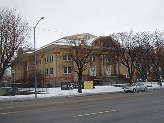
The Alpine Stake Tabernacle or Alpine Tabernacle, located at 110 East Main Street (US-89) in American Fork, Utah, United States, functions as a meeting place for large gatherings of members of the Church of Jesus Christ of Latter-day Saints in northern Utah County for worship services. The building is part of the American Fork Historic District listed on the National Register of Historic Places.

The American Fork City Hall on Church Street in American Fork, Utah was built in 1903. It was listed on the National Register of Historic Places in 1994.

The Timpanogos Cave Historic District is an 11-acre (4.5 ha) historic district in the Timpanogos Cave National Monument in American Fork Canyon in northeastern Utah County, Utah, United States, that is listed on the National Register of Historic Places (NRHP).
The American Fork Historic District is a 50-acre (20 ha) historic district in 1850-founded American Fork, Utah, United States, that was listed on the National Register of Historic Places in 1998.
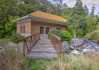
The Upper American Fork Hydroelectric Power Plant Historic District is a 1.5-acre (0.61 ha) historic district in American Fork Canyon in northeastern Utah County, Utah, United States, that is listed on the National Register of Historic Places (NRHP).

The Veterans Memorial Building at 53 N. Center in American Fork, Utah was built in 1934. It has also been known as American Fork Legion Hall and as Legion Memorial Building. It was listed on the National Register of Historic Places in 1994.

The Utah State Training School Amphitheater and Wall, is an amphitheater and boundary wall in northwest American Fork, Utah, United States, that is listed on the National Register of Historic Places.

Fork Church is a historic Episcopal church located near Ashland, Hanover County, Virginia. It was built in 1736, and is a one-story, gable roofed brick building. It measures approximately 34 feet by 74 feet and has walls 22 inches thick. The front facade features a small pedimented porch supported on square brick columns, both probably added in the early-19th century. Also on the property is a contributing church cemetery. Among the more-notable persons who often attended services at Fork Church were Patrick Henry, Dolley Madison, and the novelist Thomas Nelson Page. From 1893 to 1903, Fork Church's rector was the Reverend S. S. Hepburn, grandfather of actress Katharine Hepburn.
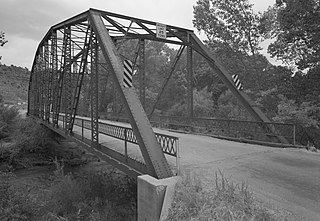
The Rockville Bridge spans the east fork of the Virgin River in Rockville, Utah, United States. The bridge was built for the National Park Service in 1924 to provide a link between Zion National Park and the North Rim area of Grand Canyon National Park. The new bridge allowed motorists to take a circular tour of the national parks in southern Utah and northern Arizona. The Rockville route was superseded in 1928 by the construction of the Zion-Mount Carmel Highway.
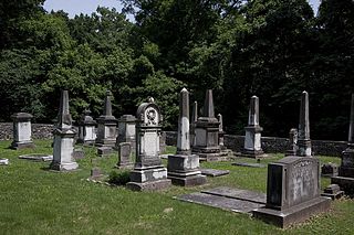
Forks of Cypress Cemetery is a historic cemetery near Florence, Alabama. The cemetery contains the graves of Forks of Cypress owner James Jackson, several members of his family, and numerous slaves who worked on the plantation. Jackson, an immigrant from County Monaghan, Ireland, purchased the estate in 1818 and built the main house in 1830. The cemetery was established soon after the estate; the oldest interment, dating from 1819, is William Augustus Moore, a relative of Jackson's wife, Sally.

Bank of American Fork is a historic commercial building in downtown American Fork, Utah, United States, that is listed on the National Register of Historic Places (NRHP) and once again serves as the headquarters of the bank (Altabank) which was formerly known as the Bank of American Fork.


