
Alappuzha district, is one of the 14 districts in the Indian state of Kerala. It was formed as Alleppey district on 17 August 1957, the name of the district being changed to Alappuzha in 1990. Alappuzha is the smallest district of Kerala. Alleppey town, the district headquarters, was renamed Alappuzha in 2012, even though the anglicised name is still commonly used to describe the town as well as the district.

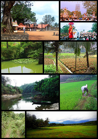
Kuttanad is a region covering the Alappuzha, Kottayam and Pathanamthitta Districts, in the state of Kerala, India, well known for its vast paddy fields and geographical peculiarities. The region has the lowest altitude in India, and is one of the few places in the world where farming is carried on around 1.2 to 3.0 metres below sea level. Kuttanad is historically important in the ancient history of South India and is the major rice producer in the state. Farmers of Kuttanad are famous for Biosaline Farming. Food and Agriculture Organization (FAO) has declared the Kuttanad Farming System as a Globally Important Agricultural Heritage System (GIAHS) in 2013.
Mavelikara is a municipality in the Alappuzha district of Kerala, India. It is located 36 km (22.4 mi) south of the district headquarters in Alappuzha and about 95 km (59.0 mi) north of the state capital Thiruvananthapuram. As per the 2011 Indian census, Mavelikkara has a population of 26,421 people, and a population density of 2,088/km2 (5,410/sq mi).

Kavalam is a village in Kuttanadu, Kerala state, Alappuzha District. India.
Kayamkulam is a municipality in the Alappuzha district of Kerala, India. It is located 90 km (55.9 mi) south of the district headquarters in Alappuzha and about 98 km (60.9 mi) north of the state capital Thiruvananthapuram. As per the 2011 Indian census, Kayamkulam has a population of 68,634 people, and a population density of 3,149/km2 (8,160/sq mi).
Alappuzha, also known as Alleppey, is a municipality in the Alappuzha district of Kerala, India. It is the district headquarters of the district, and is located about 130 km (80.8 mi) north of the state capital Thiruvananthapuram. As per the 2011 Indian census, Alappuzha has a population of 240,991 people, and a population density of 3,675/km2 (9,520/sq mi).
Haripad is a municipality in Onattukara region of Alappuzha District, Kerala, India located between Alappuzha and Kollam on the National Highway 66. Haripad is bordered on the east by Pallippad, Veeyapuram and Karuvatta to the north, Kumarapuram and Karthikappally to the West, and on the south by Cheppad. It is known as the land of art, artists, land of snake boats, land of music, dance and drama. It is also popularly known as Kshetranagari in which Haripad Temple being the chief one among them.One of the largest thermal power plants in Kerala, the Rajiv Gandhi Combined Cycle Power Plant run by the NTPC, is situated at Haripad.
Padanilam is a town located in Onattukara region of Alappuzha district, Kerala. The word Padanilam means "land of battles". It is located on the banks of river Achankovil. The Padanilam temple is one of the important centres of worship in Kerala. Nooranad is named as the Nandikesha Paithruka Gramam by the Government of Kerala due to its importance in kettukala construction, which is an icon of Onattukara region.
Ramankary is a village in the Kuttanad region of India. It is 9 km away from Changanacherry town and 17 km from Alappuzha city. It is one of the villages in Alapuzha on the bank of the Manimala River with picturesque vast paddy fields.
Pattazhy, also Pattazhi is a village located in Pathanapuram taluk in the eastern part of the Kollam District, Kerala state, India. It is best known as the site of an ancient Bhagavathy temple, Pattazhy Devi Temple.
Arattupuzha Velayudha Panicker, also known as Kallisseril Velayudha Perumal, was a 19th-century social reformer and warrior, known for his fight against many social evils prevalent in the state of Kerala. He was born into an affluent Ezhava family known as Kallisseril, in the small independent province called Mangalam, near Haripad in Alappuzha district.
Kandalloor is a village in Alappuzha district in the Indian state of Kerala.

Karthikappally is a village in Alappuzha district in the Indian state of Kerala.Haripad is the headquarter of Karthikappally Taluk. Taluk office is located at revenue tower Haripad.

Muthukulam is backwater village near Kayamkulam in Alappuzha district in the Indian state of Kerala.
Thamarakulam is a village in Alappuzha district in the Indian state of Kerala. Located in Alappuzha District of Kerala, Thamarakulam is around 16 km south-east of Kayamkulam. It is located close to the border of Kollam District and Pathanamthitta district. Kayamkulam, Mavelikara, Adoor, Ochira and Sasthamkotta are nearby towns. Nearest airport is Trivandrum International Airport, which is 110 km south. Sasthamkotta Railway Station is the nearest railhead. Kayamkulam Junction Railway and Mavelikara Railway Station is a major railhead nearby. Kollam-Theni National Highway passes through Tamarakulam Grama panchayat. Charummood is the main junction to go to Kayamkulam, Mavelikkara and Adoor. VVHS Thamarakulam and VHSS Chathiyara are major schools in Thamarakulam.
Enadimangalam is a village in the Pathanamthitta district of the state of Kerala, India. Enadimagalam includes mainly Elamanoor and Maroor. Enadimagalam is often recognised as a Panchayat. Enadimangalam had a population of around 30,000.
Pathiyankara is a small village in Alappuzha district, Kerala, India. There is a mosque where hundreds of people comes to pray every day.

Kayamkulam Kayal, Kayamkulam Lake or Kayamkulam Estuary is a shallow brackish water lagoon stretching between Panmana and Karthikapally. It has an outlet to the Arabian sea at Kayamkulam barrage. The Kayal used to be connected to the sea most of the time except during dry season when a bar like formation separates it from the sea. Now the bar has been opened up permanently for construction of Kayamkulam Fishing Harbor. Kayamkulam boat race is conducted in Kayamkulam Kayal. Kayamkulam Kayal is the third largest back water or kayal in Kerala.
Alappuzha District has four types of administrative hierarchies:

