
Lake Arrowhead is an unincorporated community and a census-designated place (CDP) in the San Bernardino Mountains of San Bernardino County, California, within the San Bernardino National Forest, surrounding the Lake Arrowhead Reservoir. Lake Arrowhead consists of 6 communities including Lake Arrowhead, Twin Peaks, Blue Jay, Cedar Glen, Sky Forest, and Rim Forest. The population of the CDP was estimated at 12,424 in the 2010 census. It was formerly called "Little Bear Lake", until around 1920, when a group from Los Angeles, the Arrowhead Lake Company, bought the lake and the land surrounding it, and changed its name to Arrowhead Lake.

San Bernardino is a city located in the Riverside–San Bernardino metropolitan area and that serves as the county seat of San Bernardino County, California, United States. As one of the Inland Empire's anchor cities, San Bernardino spans 81 square miles (210 km2) on the floor of the San Bernardino Valley and as of 2017 has a population of 216,995. San Bernardino is the 17th-largest city in California and the 102nd-largest city in the United States. San Bernardino is home to numerous diplomatic missions for the Inland Empire, being one of four cities in California with numerous consulates. The governments of Guatemala and Mexico have also established their consulates in the downtown area of the city.
Arrowhead Water, also known as Arrowhead Mountain Spring Water, is a brand of drinking water that is sold in the western United States, particularly in Nevada, Arizona, Utah, the Northwest, and in California.

Arrowhead Springs is a highly mountainous neighborhood in the 81-square-mile (210 km2) municipality of San Bernardino, California, officially annexed to the city on November 19, 2009. The neighborhood lies below the Arrowhead geological monument, which is California Historical Landmark #977.

State Route 18 in the U.S. state of California runs from State Route 210 in San Bernardino to State Route 138 in Llano. It is the primary route into the San Bernardino Mountains and has two discontinuities: one in Big Bear Lake, the other in Victorville.

State Route 173 runs from State Route 138 near the west end of Silverwood Lake in the Summit Valley south of Hesperia to State Route 18 south of Lake Arrowhead, United States. It is the only California state highway with an unpaved segment, which is a one-lane jeep trail on the Northwestern face of the San Bernardino Mountains directly east of Summit Valley and northwest of Blue Jay. The route starts at the Mojave River Forks, skims the easterly and southerly sides of Lake Arrowhead and meets State Route 189, Lake's Edge Road, at the south entrance to the Lake Arrowhead mall. The route runs entirely in San Bernardino County, mostly in the San Bernardino National Forest.
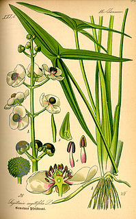
Sagittaria is a genus of about 30 species of aquatic plants whose members go by a variety of common names, including arrowhead, duck potato, katniss, Omodaka, swamp potato, tule potato, and wapato. Most are native to South, Central, and North America, but there are also some from Europe, Africa, and Asia.

Blue Jay is an unincorporated community located in San Bernardino County in California. It is located in the San Bernardino Mountains, above a region of California known as the Inland Empire.
The Arrowhead Trail or Arrowhead Highway was the first all-weather road in the Western United States that connected Los Angeles, California to Salt Lake City, Utah by way of Las Vegas, Nevada. Built primarily during the auto trails period of the 1910s, prior to the establishment of the U.S. numbered highway system, the road was replaced in 1926 by U.S. Route 91 (US 91)and subsequently Interstate 15 (I‑15). Small portions of the route in California and Las Vegas, Las Vegas Boulevard, are sometimes still referred to by the name, or as Arrow Highway.

U.S. Route 50 (US-50) in Utah crosses the center of the state. The highway serves no major population centers in Utah, with the largest city along its path being Delta. Most of the route passes through desolate, remote areas. Through the eastern half of the state the route is concurrent with Interstate 70 (I-70). US-50 both enters and exits Utah concurrent with US-6, however the two routes are separate through the center of the state.

Arrowhead Regional Medical Center (ARMC) is a teaching hospital located in Colton, California within Southern California's Inland Empire. ARMC is owned and operated by the County of San Bernardino, The emergency department (ED) at ARMC is the second busiest ED in the state of California. The hospital operates ten different residency training programs. ARMC uses the electronic health record MEDITECH.
Interstate 15 (I-15) is an Interstate Highway in the U.S. state of Nevada that begins in Primm, continues through Las Vegas and it crosses the border with Arizona in Mesquite. The freeway runs entirely in Clark County. Many motorists use I-15 to visit Las Vegas, as it is the only primary Interstate Highway in the city. The highway was built along the corridor of the older U.S. Route 91 (US 91) and Arrowhead Trail, eventually replacing both of these roads.

Lake Arrowhead is an artificial lake located in the San Bernardino Mountains on Little Bear Creek, a tributary of Deep Creek and the Mojave River. It has a surface area of approximately 780 acres (320 ha) and a capacity of 48,000 acre⋅ft (59,000 dam3). It is surrounded by the unincorporated community of Lake Arrowhead in San Bernardino County, California.

Junction House is an unincorporated community in Butte County, California. It lies at an elevation of 3517 feet.
Stirling Junction is an unincorporated community in Butte County, California. It lies at an elevation of 203 feet. The place is at the junction of the Sacramento Northern and the Southern Pacific Railroads In 1912, the junction of the Northern Pacific and the Butte County Railroads was here.
Cedar Glen, California is an unincorporated community in located in the San Bernardino National Forest resort area of San Bernardino County immediately east of Lake Arrowhead.
Parker Junction is an unincorporated community in San Bernardino County, California, United States. Parker Junction is located on U.S. Route 95 5.5 miles (8.9 km) south of Needles.
Arrowhead Farms is an unincorporated community of San Bernardino County, California. It is now a foothill and rural neighborhood of the city of San Bernardino located just northeast of the Interstate 215 and Interstate 210 junction. Arrowhead Farms is in the 92407 ZIP Code and is within the 909 area code.
Arrowhead Highlands is an unincorporated community in San Bernardino County, in the U.S. state of California.


