
Nathdwara is a town in India's western state of Rajasthan. It is located in the Aravalli hills, on the banks of the Banas River in Rajsamand District, 48 kilometres north-east of Udaipur. This town is famous for its temple of Krishna which houses the deity of Shrinathji, a 14th-century, 7-year-old "infant" incarnation of Krishna. The deity was originally worshiped at Mathura and was shifted in the 1672 from Govardhan hill, near Mathura along holy river Yamuna after being retained at Agra for almost six months. Literally, Nathdwara means ‘Gateway to Shrinathji (God)’. Nathdwara is a significant Vaishnavite shrine pertaining to the Pushti Marg or the Vallabh Sampradaya or the Shuddha Advaita founded by Vallabha Acharya, revered mainly by people of Gujarat and Rajasthan, among others. Vitthal Nathji, son of Vallabhacharya institutionalised the worship of Shrinathji at Nathdwara. Nathdwara town itself is popularly referred to as ‘Shrinathji’, after the presiding deity.
Churu is a city in the desert region of Rajasthan state of India. It is known as gateway to the Thar Desert of Rajasthan. It is the administrative headquarter of Churu District. It lies in the Thar Desert on the National Highway-65 connecting Pali to Ambala and is a junction station on the railway line to Bikaner. It is near the shifting sand dunes of the Thar Desert and has grand havelis with marvelous fresco paintings, namely Kanhaiya Lal Bagla Ki Haweli and Surana Haweli, with hundreds of small windows. It also has some fine Chhatris. Near the town is a religious seat of the Nath sect of Sadhus where there are life-size marble statues of their deities and a place for prayers. At the centre of the town is a fort built about 500 years ago.
Sikar is a city located midway between Agra and Bikaner on the National Highway 52 in the state of Rajasthan in India. It is the administrative headquarters of the Sikar District. Sikar is a historical city and contains many old havelis. It is located 114 km from Jaipur, 320 km from Jodhpur 215 km from Bikaner, and 280 km from Delhi.

Jhunjhunu is a city and headquarters of Jhunjhunu district in the state of Rajasthan, India.
Ratangarh is a town or tehsil of the Churu district in Rajasthan, India. Ratangarh was previously called Kolasar. It is famous for grand havelis (mansions) with frescoes, which is an architectural specialty of the Shekhawati region. Ratangarh is also famous for its handicraft work.
Nawalgarh is a town in Jhunjhunu district of Indian state Rajasthan. It is part of the Shekhawati region and is midway between Jhunjhunu and Sikar. It is 30 km from Sikar and 39 km from Jhunjhunu. Nawalgarh is famous for its fresco and havelis and considered as Golden City of Rajasthan. It is also the motherland of some great business families of India.

Hisar district is one of the 22 districts of Haryana, India. Hisar city serves as the district headquarters. The district is also part of Hisar division, which is headed by a commissioner who is employed by the Indian Administrative Service.
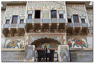
Mandawa is a town in Jhunjhunu district of Rajasthan in India. It is part of Shekhawati region. Mandawa is situated 190 km off Jaipur in the north. The town lies between latitude 28° 06’ in the north and longitude 75° 20’ in the east. Mandawa is known for its fort and havelis. The fort town of Mandawa is well connected with the other places in region through a good network of roads.

Sironj is a town and a municipality in Vidisha district in the Indian state of Madhya Pradesh.

Jhunjhunu district is a district of the Indian state Rajasthan in northern India. The city of Jhunjhunu is the district headquarters.

Bagasara is a municipality in Bagasara Taluka of Amreli district, Gujarat, India. The town is situated on the northern bank of the Satladi river.
Bissau is a city and a municipality in Jhunjhunu district in the state of Rajasthan, India.

Dibai is a town and a municipal board in Bulandshahr district. It is a tehsil town and also a constituency of legislative assembly in the state of Uttar Pradesh, India. Dibai had a population of 39902 according to census 2011.
Modak is a census town in Kota district in the Indian state of Rajasthan.Modak is in Ramganjmandi Tehsil.It is located 61 KM towards South from District head quarters Kota.
Nainwan is a tehsil of Bundi district and a municipality in the Hadoti region of the state of Rajasthan in India.
Ratannagar is a city and a municipality in Churu district in the Indian state of Rajasthan.
Bagar is a town and municipal council in the Jhunjhunu district of Rajasthan, a northwestern state in India. Known for its heritage havelis, it is located 12 kilometres (7.5 mi) from Jhunjhunu city on NH 8 towards Chirawa-Loharu.
Bagar is a small village in Pauri Garhwal district in the Indian state of Uttarakhand. The population of Bagar is around 1,275, 644 being male, and 631 being female; 247 children, ages 0 to 6, live there as of 2011. Literacy rates run around an average of 53.4%, with 66.8% for men and 40.12% for women. Bagar covers a wide geographical area of 155.22 hectares.
Kalipahari village is a big community of shekhawat Rajputs.
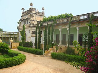
The Neemrana Hotels is an Indian organisation, noted for restoring ruins and turning them into heritage hotels.


