Bairi County དཔའ་རིས་རྫོང་ · 天祝县 Tianzhu | |
|---|---|
| དཔའ་རིས་བོད་རང་སྐྱོང་རྫོང༌། · 天祝藏族自治县 Bairi Tibetan Autonomous County | |
 | |
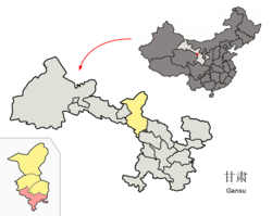 Bairi County (red) within Wuwei City (yellow) and Gansu | |
 Bairi County Location in Gansu  Bairi County Bairi County (China) | |
| Coordinates: 36°58′18″N103°08′31″E / 36.9718°N 103.1419°E | |
| Country | China |
| Province | Gansu |
| Prefecture-level city | Wuwei |
| County seat | Rabgyai (Huazangsi) |
| Area | |
• Total | 7,149 km2 (2,760 sq mi) |
| Highest elevation | 4,874 m (15,991 ft) |
| Lowest elevation | 2,040 m (6,690 ft) |
| Population (2020) [1] | |
• Total | 151,031 |
| • Density | 21/km2 (55/sq mi) |
| Time zone | UTC+8 (China Standard) |
| Postal code | 733200 |
| Website | www |
- ↑ "武威市第七次全国人口普查公报" (in Chinese). Government of Wuwei. 2021-05-27.
- ↑ "天祝旅游网". Archived from the original on 2013-02-04. Retrieved 2012-01-19.
- 1 2 "甘肃·天祝 - 走进天祝". www.gstianzhu.gov.cn. Retrieved 2020-12-31.
- 1 2 3 "天祝藏族自治县". 13 July 2004.
- ↑ 2022年统计用区划代码和城乡划分代码 (in Chinese). National Bureau of Statistics of the People's Republic of China.
- 1 2 中国气象数据网 – WeatherBk Data (in Simplified Chinese). China Meteorological Administration . Retrieved 24 September 2023.
- ↑ 中国气象数据网 (in Simplified Chinese). China Meteorological Administration . Retrieved 24 September 2023.
- ↑ 中国气象数据网 (in Simplified Chinese). China Meteorological Administration . Retrieved 24 September 2023.
Further reading
- A. Gruschke: The Cultural Monuments of Tibet’s Outer Provinces: Amdo - Volume 2. The Gansu and Sichuan Parts of Amdo, White Lotus Press, Bangkok 2001. ISBN 974-480-049-6
- Tsering Shakya: The Dragon in the Land of Snows. A History of Modern Tibet Since 1947, London 1999, ISBN 0-14-019615-3
| Bairi Tibetan Autonomous County | |||||||
|---|---|---|---|---|---|---|---|
| Chinese name | |||||||
| Simplified Chinese | 天祝藏族自治县 | ||||||
| Traditional Chinese | 天祝藏族自治縣 | ||||||
| |||||||
| Prefecture-level cities | |
|---|---|
| Autonomous prefectures | |
| International | |
|---|---|
| National | |