
The Ouachita National Forest is a vast congressionally-designated National Forest that lies in the western portion of Arkansas and portions of extreme-eastern Oklahoma, USA.

Lake Hamilton and Lake Catherine are a pair of man-made lakes located in Hot Springs, Arkansas, serving as a tourist attraction for the area. Both Lakes were developed by Arkansas Power & Light.

Mansfield Hollow Lake is a reservoir resting on the border of Windham County and Tolland County, Connecticut. The reservoir provides drinking water for Willimantic and helps control flooding in the 159-square-mile Thames River watershed. It was created by the Mansfield Hollow Dam and is entirely contained within Mansfield Hollow State Park and the Mansfield Hollow Wildlife Area. Designed and constructed by the United States Army Corps of Engineers, the dam substantially reduces flooding along the Quinebaug, Shetucket, and Thames rivers. Construction of the project began in 1949 with completion in 1952 at a cost of US$6.5 million. The Mansfield Hollow reservoir is located within the Shetucket River Watershed and is part of the Thames River Basin. Access to the site is available from US Route 6 and State Route 195. The damsite, covering an area of 25 acres (10 ha), was listed on the National Register of Historic Places in 2003.
Athens is an unincorporated community in the northeastern corner of Howard County, Arkansas, Arkansas, United States. It is located at the junction of Arkansas Highways 84 and 246.

U.S. Highway 71 is a U.S. highway that runs from Krotz Springs, LA to the Fort Frances–International Falls International Bridge at the Canadian border. In Arkansas, the highway runs from the Louisiana state line near Doddridge to the Missouri state line near Bella Vista. In Texarkana, the highway runs along State Line Avenue with US 59 and partially runs in Texas. Other areas served by the highway include Fort Smith and Northwest Arkansas.
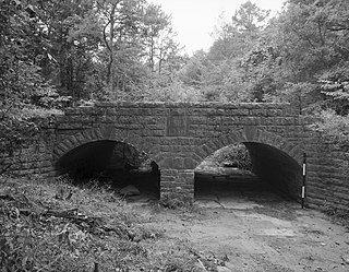
The Mulladay Hollow Bridge is a stone arch bridge in rural Carroll County, Arkansas. It carries County Road 204 across Mulladay Hollow Creek, near the southwestern tip of Lake Leatherwood It has two spans, and is built out of roughly square and semi-coursed fieldstone. The arches are elliptical in shape, 9 feet (2.7 m) in height and 9.5 feet (2.9 m) wide, with nearly-square voussoirs forming the arches. The barrels of the arches are skewed with respect to the spandrels, and the wing walls are slightly curved. The roadway carried by the bridge is 30 feet (9.1 m) wide, and the total length of the structure is 120 feet (37 m). The bridge was built with Works Progress Administration funding as part of the development of Lake Leatherwood as a recreation area.

The Bard Springs Bathhouse is a historic recreational support facility in Ouachita National Forest. It is located at the Bard Springs recreation site, southeast of Mena and north of Athens in Polk County, off County Road 82 and Forest Road 106 on the banks of Blaylock Creek. It is a single story rustic stone structure, with entrances at either end into open areas for changing. The interior is lit by skylights in the roof. It was built in 1936 by a crew of the Civilian Conservation Corps, and is one of four surviving CCC structures in the immediate area.

The Bard Springs Dam No. 2 is a historic recreational support facility in Ouachita National Forest. It is located at the Bard Springs recreation site, southeast of Mena and north of Athens in Polk County, off County Road 82 and Forest Road 106 on the banks of Blaylock Creek. This dam is located at the eastern end of the recreation area, and is about 75 feet (23 m) long and 15 feet (4.6 m) high at its center. It is made of fieldstone, and has a series of staggered steps at its base to reduce erosion. It was built in 1936 by a crew of the Civilian Conservation Corps, and is one of four surviving CCC structures in the immediate area.
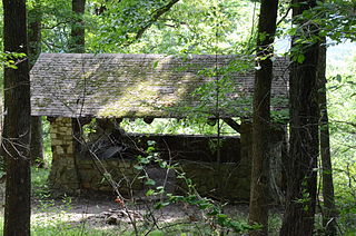
The Bard Springs Picnic Shelter is a historic recreational support facility in Ouachita National Forest. It is located at the Bard Springs recreation site, southeast of Mena and north of Athens in Polk County, off County Road 82 and Forest Road 106 on the banks of Blaylock Creek. It is a square open-air structure, with four rustic stone columns supporting a gabled roof. The foundation is stone, with the support columns set in concrete blocks. It was built in 1936 by a crew of the Civilian Conservation Corps, and is one of four surviving CCC structures in the immediate area.
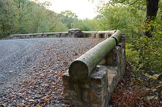
The Buckeye Vista Overlook is a historic scenic overlook in Ouachita National Forest. It is located on Ouachita National Forest Road 38 on the north side of Buckeye Mountain. The overlook is a simple roadside pullout on the north side of the road, with a retaining wall about 70 feet (21 m) long. The wall was built out of quarried stone and mortar in 1935 by a crew of the Civilian Conservation Corps (CCC). It is one of only two CCC-built overlooks in the national forest.

Shady Lake Recreation Area is a campground and public recreation area in southwestern Ouachita National Forest, southwest of Mena, Arkansas and west of Glenwood, Arkansas. The area is oriented around Shady Lake, a body of water on the South Fork Saline River impounded by a dam built c. 1940 by the Civilian Conservation Corps (CCC). The area is administered by the United States Forest Service (USFS).

The Sugar Creek Vista Overlook is a historic scenic overlook in Ouachita National Forest. It is located on Polk County Road 64, just south of Dicks Gap. The overlook is a simple roadside pullout on the west side of the road, with an angular retaining wall about 84 feet (26 m) long. The wall was built out of quarried novaculite stone set with grapevine mortar joints in 1935 by a crew of the Civilian Conservation Corps (CCC). It is one of only two CCC-built overlooks in the national forest, and the only one built with these particular materials.
The North Sylamore Creek Bridge is a historic bridge in the Ozark-St. Francis National Forest in northern Stone County, Arkansas. It is a Baltimore deck truss bridge, carrying Forest Service Road 1102 over North Sylamore Creek near the Gunner Pool Recreation Area. The bridge has two spans, each 110 feet (34 m) long, with a total structure length of 357 feet (109 m). It rests on concrete piers and abutments. The bridge was built in 1931, and is the only known example of this type of truss in the state.
The Gray Spring Recreation Area is a picnic area with scenic views in the Ozark-St. Francis National Forest of northwestern Arkansas. It is located on northern Franklin County, on Forest Road 1003, and includes a picnic shelter, comfort facilities, an outdoor barbecue pit, and picnic tables. The picnic area and Forest Road 1003 were built in 1934 by a crew from the Civilian Conservation Corps, and were listed on the National Register of Historic Places in 1995. The road, which winds precariously around Black Mountain, retains a number of surviving CCC-built features, including a bridge and many stone culverts.

The Charlton Recreation Area is a public use area of the Ouachita National Forest, located just north of United States Route 270 between Crystal Springs and Mount Ida, Arkansas. The area includes a campground and day use facilities for water-related activities on Walnut Creek, including fishing and swimming. The facilities are organized around a small artificial lake created in 1938 by a crew of the Civilian Conservation Corps by damming the creek. The stone Charlton Dam and Spillway, about 100 feet (30 m) in length, was listed on the National Register of Historic Places 1993, as was the stone Charlton Bathhouse, also built by the CCC in 1938.

The Crystal Campground is located on Forest Road 177 in Ouachita National Forest, northeast of Norman, Arkansas. The campground has nine campsites and a picnic shelter, and provides access to outdoor recreational activities including hiking, swimming, and fishing. The swimming area is made possible by the Crystal Springs Dam, a 30-foot (9.1 m) fieldstone dam built in 1935 by the Civilian Conservation Corps, that impounds Montgomery Creek to provide a swimming hole. The campground's main picnic shelter was also built by the CCC at that time. Both the dam and the shelter were listed on the National Register of Historic Places in 1993.

The Iron Springs Recreation Area is a roadside picnic area on Arkansas Highway 7, north of Jessieville in the Ouachita National Forest. The area has three shelters for picnicking, vault toilets, and an accessible trail for viewing the springs in the area. The facilities were largely built by the Civilian Conservation Corps (CCC) in the 1930s, with two shelters and the nearby dam listed on the National Register of Historic Places.

The Follett Stone Arch Bridge Historic District encompasses a group of four stone arch bridges in southwestern Townshend, Vermont. All four bridges were built by James Otis Follett, a local self-taught mason, between 1894 and 1910, and represent the single greatest concentration of surviving bridges he built. The district was listed on the National Register of Historic Places in 1976.
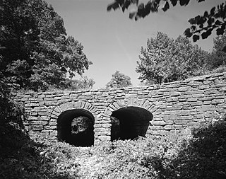
The Spring Lake Bridge is a historic bridge in the eastern part of Ozark-St. Francis National Forest, carrying County Road 35 across an inlet of Spring Lake known as Bob Barnes Branch, in the Spring Lake Recreation Area with the Ozark–St. Francis National Forest. It is a two-span closed-spandrel stone arch bridge with a total length of 36 feet (11 m). Each arch is 10 feet (3.0 m) long and 6 feet (1.8 m) high. Built in 1936 with federal funding, it is one of the state's finest examples of a stone arch bridge.

The Spring Lake Recreation Area is a recreational facility of the Ozark-St. Francis National Forest in Yell County, Arkansas. It is located north of Danville, in and around Spring Lake, a man-made lake constructed in 1937 with funding from the Works Progress Administration. The area has facilities for fishing and picnicking, including many structures built with WPA funding the Rustic style common to work of the Civilian Conservation Corps. Facilities from that period include picnic pavilions and developed picnic sites, a bathhouse, two swimming platforms, the Spring Lake Bridge, and the dam which impounds Spring Creek at the southern end of the lake. The area was listed on the National Register of Historic Places in 1995 as the Spring Lake Recreation Area Historic District.


