Bhote Koshi

Last updated
Bhote Koshi (Poiqu)
Bhote Kosi near Tibet.JPG
Bhote Koshi near the Tibetan border during dry season
Physical characteristics
Main source Zhangzangbo Glacier, Tibet Autonomous Region
8,012 m (26,286 ft)
River mouth Sun Kosi near Balephi, Sindhupalchowk, Nepal
640 m (2,100 ft) [1]
27°43′58″N85°46′47″E / 27.73278°N 85.77972°E / 27.73278; 85.77972 Coordinates: 27°43′58″N85°46′47″E / 27.73278°N 85.77972°E / 27.73278; 85.77972
Basin features
River system Koshi River

The Bhote Koshi is the upper river course of the Sun Kosi, known as Poiqu in Tibet. [2] It is part of the Koshi River system in Nepal. [1]

Sun Kosi river in Nepal

The Sun Kosi, also called Sun Koshi, is a trans-boundary river that originates in the Tibet and it is part of the Koshi or Saptkoshi River system in Nepal.

Tibet plateau region in Asia

Tibet is a historical region covering much of the Tibetan Plateau in Inner Asia. It is the traditional homeland of the Tibetan people as well as some other ethnic groups such as Monpa, Tamang, Qiang, Sherpa, and Lhoba peoples and is now also inhabited by considerable numbers of Han Chinese and Hui people. Tibet is the highest region on Earth, with an average elevation of 4,900 metres (16,000 ft). The highest elevation in Tibet is Mount Everest, Earth's highest mountain, rising 8,848 m (29,029 ft) above sea level.

Koshi River river in China, Nepal and India

The Koshi or Kosi River drains the northern slopes of the Himalayas in Tibet and the southern slopes in Nepal. From a major confluence of tributaries north of the Chatra Gorge onwards, the Koshi River is also known as Saptakoshi for its seven upper tributaries. These include the Tamor River originating from the Kanchenjunga area in the east and Arun River and Sun Koshi from Tibet. The Sun Koshi's tributaries from east to west are Dudh Koshi, Bhote Koshi, Tamakoshi River, Likhu Khola and Indravati. The Saptakoshi crosses into northern Bihar where it branches into distributaries before joining the Ganges near Kursela in Katihar district.

Contents

A western tributary of the upper Dudh Koshi is also called Bhote Koshi. [3]

River course

The valley of Bhote Koshi Bhote Koshi.JPG
The valley of Bhote Koshi

The headwaters of Poiqu and Bhote-Sun Koshi River are located at the Zhangzangbo Glacier in Tibet. [4] The river flows out of the Lumi Chimi lake. When entering Nepal, it is called Bhote Koshi. Further downstream, from the village of Bahrabise onwards, it is called Sun Koshi. [1]

Glacier Persistent body of ice that is moving under its own weight

A glacier is a persistent body of dense ice that is constantly moving under its own weight; it forms where the accumulation of snow exceeds its ablation over many years, often centuries. Glaciers slowly deform and flow due to stresses induced by their weight, creating crevasses, seracs, and other distinguishing features. They also abrade rock and debris from their substrate to create landforms such as cirques and moraines. Glaciers form only on land and are distinct from the much thinner sea ice and lake ice that form on the surface of bodies of water.

Bahrabise municipalitiy in Bagmati Zone, Nepal

Bahrabise is a city in Sindhupalchok District in the Bagmati Zone of central Nepal. It consists of nine wards.

Hazards

In July 1981, a sudden ice avalanche caused a Glacial Lake Outburst Flood in the moraine-dammed Zhangzangbu-Cho Lake in the headwaters of the Bhote Koshi. The ensuing debris flow destroyed bridges, and sections of both the Arniko and the Nepal–China highways. [5]

Avalanche sudden, drastic flow of snow down a slope

An avalanche is an event that occurs when a cohesive slab of snow lying upon a weaker layer of snow fractures and slides down a steep slope. Avalanches are typically triggered in a starting zone from a mechanical failure in the snowpack when the forces of the snow exceed its strength but sometimes only with gradual widening. After initiation, avalanches usually accelerate rapidly and grow in mass and volume as they entrain more snow. If the avalanche moves fast enough, some of the snow may mix with the air forming a powder snow avalanche, which is a type of gravity current.

Moraine Glacially formed accumulation of unconsolidated debris

A moraine is any glacially formed accumulation of unconsolidated glacial debris that occurs in both currently and formerly glaciated regions on Earth, through geomorphological processes. Moraines are formed from debris previously carried along by a glacier and normally consisting of somewhat rounded particles ranging in size from large boulders to minute glacial flour. Lateral moraines are formed at the side of the ice flow and terminal moraines at the foot, marking the maximum advance of the glacier. Other types of moraine include ground moraines, till-covered areas with irregular topography, and medial moraines which are formed where two glaciers meet.

Debris is rubble, wreckage, ruins, litter and discarded garbage/refuse/trash, scattered remains of something destroyed, discarded, or as in geology, large rock fragments left by a melting glacier etc. Depending on context, debris can refer to a number of different things. The first apparent use of the French word in English is in a 1701 description of the army of Prince Rupert upon its retreat from a battle with the army of Oliver Cromwell, in England.

Names and etymology

Nepali : भोटे कोशी; Chinese :波特科西; pinyin :Bōtè Kēxī

Nepali language pene ficial language of Nepal

Nepali, known by the endonym Khas Kura also known as Gorkhali or Parbatiya, is an Indo-Aryan language of the sub-branch of Eastern Pahari. It is the official language of Nepal and one of the official status gained language of India. It is spoken mainly in Nepal and by about a quarter of the population in Bhutan. In India, Nepali is listed in the Eighth Schedule to the Constitution as an Indian language, with official status in the state of Sikkim, and spoken in Northeast Indian states such as Assam and in West Bengal's Darjeeling district. It is also spoken in Burma and by the Nepali diaspora worldwide. Nepali developed in proximity to a number of Indo-Aryan languages, most notably the other Pahari languages and Maithili, and shows Sanskrit influence. However, owing to Nepal's location, it has also been influenced by Tibeto-Burman languages. Nepali is mainly differentiated from Central Pahari, both in grammar and vocabulary, by Tibeto-Burman idioms owing to close contact with this language group.

Chinese language family of languages

Chinese is a group of related, but in many cases not mutually intelligible, language varieties, forming the Sinitic branch of the Sino-Tibetan language family. Chinese is spoken by the Han majority and many minority ethnic groups in China. About 1.2 billion people speak some form of Chinese as their first language.

Hanyu Pinyin, often abbreviated to pinyin, is the official romanization system for Standard Chinese in mainland China and to some extent in Taiwan. It is often used to teach Standard Mandarin Chinese, which is normally written using Chinese characters. The system includes four diacritics denoting tones. Pinyin without tone marks is used to spell Chinese names and words in languages written with the Latin alphabet, and also in certain computer input methods to enter Chinese characters.

In Nepali language, the word "bhoṭe" or "bhoṭiyā" means Tibetan; [6] and the word "kosi" means river. [7]

Tourism and sports

The Bhote Kosi is used for both rafting and kayaking. It is the steepest river rafted in Nepal, with a gradient of 15 m per km. Bungee jumping or swinging over the Bhote Kosi has been described as the ‘ultimate experience’. [8]

The river carves a steep and direct drop at the top that gradually eases to more placid streams and calmer pools with a 46-km run at the Lamosunga dam. The rapids are class IV-V at high flow, and III at lower levels. The river is steep and continuous with one rapid leading into another.

Related Research Articles

Geography of Nepal

Nepal measures about 800 kilometers (497 mi) along its Himalayan axis by 150 to 250 kilometers across. Nepal has an area of 147,181 square kilometers (56,827 sq mi).

Himalayas mountain range in Central Asia

The Himalayas, or Himalaya, form a mountain range in Asia, separating the plains of the Indian subcontinent from the Tibetan Plateau.

Bagmati River river in India

The Bagmati River runs through the Kathmandu Valley of Nepal and separates Kathmandu from Patan. It is considered holy by both Hindus and Buddhists. A number of Hindu temples are located on its banks.

Proglacial lake A lake formed either by the damming action of a moraine during the retreat of a melting glacier, a glacial ice dam, or by meltwater trapped against an ice sheet

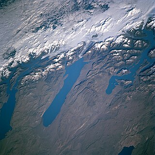
In geology, a proglacial lake is a lake formed either by the damming action of a moraine during the retreat of a melting glacier, a glacial ice dam, or by meltwater trapped against an ice sheet due to isostatic depression of the crust around the ice. At the end of the last ice age approximately 10,000 years ago, large proglacial lakes were a widespread feature in the northern hemisphere.

Dudh Kosi river in Nepal

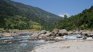
Dudh Koshi is a river in eastern Nepal. It is the highest river in terms of elevation.

Tamur River river in Nepal

The Tamur River, also called Tamor Nadi, is a major river in eastern Nepal, which begins around Kanchenjunga. The Tamur and the Arun join the Sun Kosi at Tribenighat to form the giant Saptakoshi which flows through Mahabharat Range on to the Gangetic plain

Kosi may refer to:

Sindhupalchok District District in Province No. 3, Nepal

Sindhupalchok District is a part of Province No. 3 and one of the seventy-seven districts of Nepal, with an area of 2,542 km2 (981 sq mi). The district's headquarters is in Chautara. In 2006, 336,478 people resided in 79 village development committees, in 2011 there were 287,798.

Glacial lake outburst flood A type of outburst flood that occurs when the dam containing a glacial lake fails

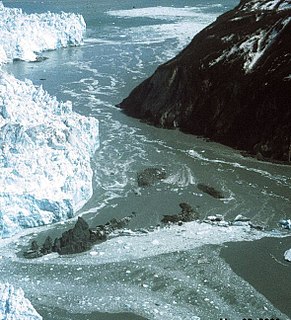
A glacial lake outburst flood (GLOF) is a type of outburst flood that occurs when the dam containing a glacial lake fails. An event similar to a GLOF, where a body of water contained by a glacier melts or overflows the glacier, is called a Jökulhlaup. The dam can consist of glacier ice or a terminal moraine. Failure can happen due to erosion, a buildup of water pressure, an avalanche of rock or heavy snow, an earthquake or cryoseism, volcanic eruptions under the ice, or if a large enough portion of a glacier breaks off and massively displaces the waters in a glacial lake at its base.

Arun River, China–Nepal watercourse

The Arun River is a trans-boundary river and is part of the Kosi or Sapt Koshi river system in Nepal. It originates in Tibet Autonomous Region of the People's Republic of China where it is called the Phung Chu or Bum-chu.

The Inner Terai Valleys of Nepal comprise several elongated river valleys in the southern lowland Terai part of the country. These tropical valleys are enclosed by the Himalayan foothills, viz the Mahabharat Range and the Sivalik Hills farther south. The Inner Terai is called "bhitri Terai " in Nepali language.

The Kosi embankments were built in late 1950s to retain the Kosi River which is a transboundary river between Nepal and India and is one of the largest tributaries of the Ganges. It was conceptualised during the first Bihar Government of CM Shri Babu and his deputy Anugraha Babu. According to the agreement with Nepal, the responsibility of maintaining these embankments was vested in the Government of Bihar.

Indravati River, Nepal river in Nepal

The Indravati River in Nepal is a tributary of the Sun Koshi River. It used to be called "Melamchi" or "Melamchu" until the 19th century.

Barun River river in Nepal

The Barun River is a tributary of the Arun River and is part of the Kosi river system in Nepal.

Imja Khola river in Nepal

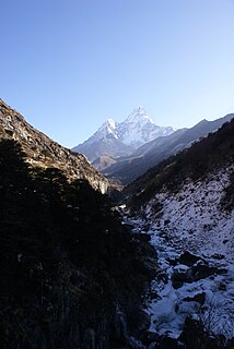
The Imja Khola is a tributary of the Dudh Kosi in Nepal. It drains the slopes of Mount Everest. The Khumbu Glacier melts into the Lobujya (Lobuche) River, which flows southward as the Imja Khola to its confluence with the Dudh Kosi at Tengboche.

Imja Tsho lake in Nepal

Imja Tsho is a glacial lake created after melt water began collecting at the foot of the Imja Glacier on the lower part of the glacier in the 1950s. A 2009 study described this lake of melt water as one of the fastest-growing in the Himalaya. Held in place by a terminal moraine, Imja Tsho threatens downstream communities with the potential for a glacial outburst flood.

Chatra Gorge

The Chatra Gorge is a canyon cut by the Kosi River across the Mahabharat Range in Nepal.

In 2010, the Government of Nepal approved National Adaptation Programme of Action (NAPA). NAPA developed as a requirement under the UNFCCC to access funding for the most urgent and immediate adaptation needs from the Least Developed Countries Fund (LDCF).

References

  1. 1 2 3 Shrestha, A. B., Eriksson, M., Mool, P., Ghimire, P., Mishra, B., & Khanal, N. R. (2010). Glacial lake outburst flood risk assessment of Sun Koshi basin, Nepal. Geomatics, Natural Hazards and Risk 1(2): 157–169.
  2. Yamada, T., Sharma, C. K. (1993). Glacier lakes and outburst floods in the Nepal Himalaya. IAHS Publications-Publications of the International Association of Hydrological Sciences, 218: 319–330.
  3. Kattelmann, R. (2003). Glacial lake outburst floods in the Nepal Himalaya: a manageable hazard? Natural Hazards 28(1): 145–154.
  4. Bajracharya, S. R., Mool, P. K., Shrestha, B. R. (2006). The impact of global warming on the glaciers of the Himalaya. Pages 231–242 in: Proceedings of the International Symposium on Geodisasters, Infrastructure Management and Protection of World Heritage Sites. Nepal Engineering College, Ehime College and National Society for Earthquake Technology Nepal.
  5. Mool, P. K.; Joshi, S. P.; Bajracharya, S. R. (2001). Glacial Lake Outburst Floods and Damage in the Country. Pages 121–136 in: Inventory of Glaciers, Glacial Lakes and Glacial Lake Outburst Floods: Monitoring and Early Warning Systems in the Hindu Kush-Himalayan Region, Nepal. International Centre for Integrated Mountain Development, Kathmandu.
  6. Turner, R. L. (1931). "bhote". A Comparative and Etymological Dictionary of the Nepali Language. K. Paul, Trench, Trubner: London.
  7. Turner, R. L. (1931). "kosi". A Comparative and Etymological Dictionary of the Nepali Language. K. Paul, Trench, Trubner: London.
  8. Bindloss, J. (2010). "Bungee Jumping". Nepal. Lonely Planet. p. 87. ISBN   9781742203614 . Retrieved 2010-05-23.