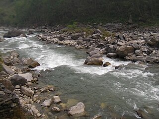
Sun Kosi

Last updated
Sun Kosi (Poiqu)
The Friendship Bridge connecting China with Nepal.jpg
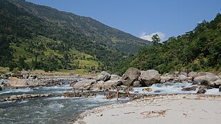
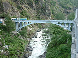
The Sino-Nepal Friendship Bridge over the Sun Kosi at Kodari
Location
CountryTibet, Nepal
Physical characteristics
Source 
  location Tibet
  elevation8,012 m (26,286 ft)
Mouth  
  location
Confluence with Arun and Tamur to form Saptkoshi at Trivenighat, Nepal
  coordinates
26°54′47″N87°09′25″E / 26.913°N 87.157°E / 26.913; 87.157 Coordinates: 26°54′47″N87°09′25″E / 26.913°N 87.157°E / 26.913; 87.157
  elevation
640 m (2,100 ft) [1]
Basin features
River system Koshi River
Tributaries 
  leftTamba Koshi, Likhu Khola, Dudh Koshi
  right Indravati River

The Sun Kosi, also called Sun Koshi, is a trans-boundary river that originates in the Tibet and it is part of the Koshi or Saptkoshi River system in Nepal. [1]

Tibet Autonomous Region Autonomous region

The Tibet Autonomous Region (TAR) or Xizang Autonomous Region, called Tibet or Xizang for short, is a province-level autonomous region in southwest China. It was formally established in 1965 to replace the Tibet Area, an administrative division the People's Republic of China (PRC) took over from the Republic of China (ROC) about five years after the dismissal of the Kashag by the PRC following the 1959 Tibetan uprising, and about 13 years after Tibet's incorporation into the PRC in 1951.

Koshi River river in China, Nepal and India

The Koshi or Kosi River drains the northern slopes of the Himalayas in Tibet and the southern slopes in Nepal. From a major confluence of tributaries north of the Chatra Gorge onwards, the Koshi River is also known as Saptakoshi for its seven upper tributaries. These include the Tamor River originating from the Kanchenjunga area in the east and Arun River and Sun Koshi from Tibet. The Sun Koshi's tributaries from east to west are Dudh Koshi, Bhote Koshi, Tamakoshi River, Likhu Khola and Indravati. The Saptakoshi crosses into northern Bihar where it branches into distributaries before joining the Ganges near Kursela in Katihar district.

Nepal A landlocked country in the Himalayas

Nepal, officially Federal Democratic Republic of Nepal, is a landlocked country in South Asia. It is located mainly in the Himalayas, but also includes parts of the Indo-Gangetic Plain. With an estimated population of 26.4 million, it is 48th largest country by population and 93rd largest country by area. It borders China in the north and India in the south, east and west while Bangladesh is located within only 27 km (17 mi) of its southeastern tip and Bhutan is separated from it by the Indian state of Sikkim. Nepal has a diverse geography, including fertile plains, subalpine forested hills, and eight of the world's ten tallest mountains, including Mount Everest, the highest point on Earth. Kathmandu is the capital and the largest city. Nepal is a multiethnic country with Nepali as the official language.

Contents

River course

The Sun Kosi's headwaters are located in the Zhangzangbo Glacier in Tibet. [2] Its upper course, the Bhote Koshi, is known as Poiqu in Tibet. [3] Both river courses together form one basin that covers an area of about 3,394 km2 (1,310 sq mi). [1]

Glacier Persistent body of ice that is moving under its own weight

A glacier is a persistent body of dense ice that is constantly moving under its own weight; it forms where the accumulation of snow exceeds its ablation over many years, often centuries. Glaciers slowly deform and flow due to stresses induced by their weight, creating crevasses, seracs, and other distinguishing features. They also abrade rock and debris from their substrate to create landforms such as cirques and moraines. Glaciers form only on land and are distinct from the much thinner sea ice and lake ice that form on the surface of bodies of water.

Bhote Koshi river in Nepal

The Bhote Koshi is the upper river course of the Sun Kosi, known as Poiqu in Tibet. It is part of the Koshi River system in Nepal.

The Indravati meets the Sun Kosi at Dolaghat, up to where it is followed by the Arniko Rajmarg. [4] From there, the Sun Kosi flows eastwards through the valley formed between the Mahabharat Range and the Himalayas. [1] Tamakosi, Likhu, Dudhkosi, Arun and Tamor are its left tributaries and Indravati is the right tributary.

Indravati River, Nepal river in Nepal

The Indravati River in Nepal is a tributary of the Sun Koshi River. It used to be called "Melamchi" or "Melamchu" until the 19th century.

Himalayas Mountain range in Asia

The Himalayas, or Himalaya, form a mountain range in Asia, separating the plains of the Indian subcontinent from the Tibetan Plateau. The range has many of the Earth's highest peaks, including the highest, Mount Everest. The Himalayas include over fifty mountains exceeding 7,200 m (23,600 ft) in elevation, including ten of the fourteen 8,000-metre peaks. By contrast, the highest peak outside Asia is 6,961 m (22,838 ft) tall.

The average annual flow is 22 x 109 m3. The average sediment load is 54 x 106 m3. [5]

Sediment Particulate solid matter that is deposited on the surface of land

Sediment is a naturally occurring material that is broken down by processes of weathering and erosion, and is subsequently transported by the action of wind, water, or ice or by the force of gravity acting on the particles. For example, sand and silt can be carried in suspension in river water and on reaching the sea bed deposited by sedimentation. If buried, they may eventually become sandstone and siltstone through lithification.

The Tamur and the Arun rivers join the Sun Kosi at Tribenighat to form the Saptkoshi, which flows through the Chatra Gorge across the Mahabharat Range on to the Gangetic plain. [6]

Tamur River river in Nepal

The Tamur River, also called Tamor Nadi, is a major river in eastern Nepal, which begins around Kanchenjunga. The Tamur and the Arun join the Sun Kosi at Tribenighat to form the giant Saptakoshi which flows through Mahabharat Range on to the Gangetic plain

Chatra Gorge

The Chatra Gorge is a canyon cut by the Kosi River across the Mahabharat Range in Nepal.

There are few more smaller tributaries of the Sun Kosi such as Rosi Khola, Junga Khola,and Sapsu Khola.

Names and etymology

Nepali : सुनकोशी

In Nepali language, the word "sun" means gold and golden; [7] and the word "kosi" means river. [8]

Nepali language Lingua franca of Nepal; one of the scheduled languages of India

Nepali is an Indo-Aryan language of the sub-branch of Eastern Pahari. It is the official language of Nepal and one of the 22 scheduled languages of India. Also known by the endonym Khas kura, the language is also called Gorkhali or Parbatiya in some contexts, It is spoken mainly in Nepal and by about a quarter of the population in Bhutan. In India, Nepali has official status in the state of Sikkim, and significant number of speakers in the states of Arunachal Pradesh, Himachal Pradesh, Manipur, Mizoram, Uttarakhand and West Bengal's Darjeeling district. It is also spoken in Burma and by the Nepali diaspora worldwide. Nepali developed in proximity to a number of Indo-Aryan languages, most notably the other Pahari languages and Maithili, and shows Sanskrit influence. However, owing to Nepal's location, it has also been influenced by Tibeto-Burman languages. Nepali is mainly differentiated from Central Pahari, both in grammar and vocabulary, by Tibeto-Burman idioms owing to close contact with this language group.

Gold Chemical element with atomic number 79

Gold is a chemical element with the symbol Au and atomic number 79, making it one of the higher atomic number elements that occur naturally. In its purest form, it is a bright, slightly reddish yellow, dense, soft, malleable, and ductile metal. Chemically, gold is a transition metal and a group 11 element. It is one of the least reactive chemical elements and is solid under standard conditions. Gold often occurs in free elemental (native) form, as nuggets or grains, in rocks, in veins, and in alluvial deposits. It occurs in a solid solution series with the native element silver and also naturally alloyed with copper and palladium. Less commonly, it occurs in minerals as gold compounds, often with tellurium.

Koshi River system

The Koshi River drains eastern Nepal. It is also known as Saptkoshi River because of the seven rivers joining in east-central Nepal to form this river. The main rivers forming the Koshi River system are Sun Koshi, Indravati, Tamba Koshi, Bhote Koshi, Dudh Kosi, Arun and Tamur Rivers. The Saptkoshi River flows through the Chatra Gorge in a southerly direction into northern Bihar and joins the Ganges. [6] [9]

The Sun Koshi contributes about 44% of the total water of the Saptakoshi, the Arun 37% and the Tamur 19%. [10]

Sun Kosi–Kamala multipurpose project

The Sun Kosi has a 90% reliable flow of 126 cubic metres per second (4,400 cu ft/s). It has been proposed that water be diverted from a small weir across the river near Kurule through a 16.6 kilometres (10.3 mi) tunnel and a 61.4 MW associated power house to the Kamala River, flowing through central Nepal. Some 72 cubic metres per second (2,500 cu ft/s) of water would be transferred to the Kamala River for the purposes of irrigation and further generation of power. [11] [12]

Hazards

In July 1981, a sudden ice avalanche caused a Glacial Lake Outburst Flood in the moraine-dammed Zhangzangbu-Cho Lake in the headwaters of the Poiqu in Tibet. The ensuing debris flow destroyed bridges, and sections of both the Arniko and the Nepal–China highways. [2]

On 2 August 2014, a landslide blocked the river downstream from Barabise and created a large lake that submerged a hydropower station. The collapsed river bed buried several houses, more than 30 people died. The area has been declared a flood crisis zone, and local communities are evacuated. Power supply is interrupted, and the Arniko Highway blocked. [13] See also 2014 Sunkoshi blockage

Water sports

The Sun Kosi is used for both rafting and intermediate kayaking. It has grade III-IV rapids. The most common put in point of a Sun Kosi river trip is Dolalghat, at a height of 620 m (2,030 ft) and it ends at the Chatra Gorge at 115 m (377 ft), a distance of around 272 km (169 mi). [14]

The first successful descent of the Sun Kosi was made in late September 1970 by Daniel C. Taylor, Terry Bech, Cheri Bremer-Kamp, and Carl Schiffler. They put into the river at Dolaghat and exited at the Nepal/India border. Their expedition took four days. [15] Prior to this successful trip, there are four known unsuccessful attempts to descend the river, and one unsuccessful attempt to ascend the river in a jet boat under the leadership of Sir Edmund Hillary. [16]

Related Research Articles

Geography of Nepal

Nepal measures about 800 kilometers (497 mi) along its Himalayan axis by 150 to 250 kilometers across. Nepal has an area of 147,181 square kilometers (56,827 sq mi).

Bagmati River River in Nepal

The Bagmati River runs through the Kathmandu Valley of Nepal and separates Kathmandu from Patan. It is considered holy by both Hindus and Buddhists. A number of Hindu temples are located on its banks.

Dudh Koshi

Dudh Koshi is a river in eastern Nepal. It is the highest river in terms of elevation.

Kosi may refer to:

Sindhupalchok District District in Province No. 3, Nepal

Sindhupalchok District is a part of Province No. 3 and one of the seventy-seven districts of Nepal, with an area of 2,542 km2 (981 sq mi). The district's headquarters is in Chautara. In 2006, 336,478 people resided in 79 village development committees, in 2011 there were 287,798.

Glacial lake outburst flood A type of outburst flood that occurs when the dam containing a glacial lake fails

A glacial lake outburst flood (GLOF) is a type of outburst flood that occurs when the dam containing a glacial lake fails. An event similar to a GLOF, where a body of water contained by a glacier melts or overflows the glacier, is called a Jökulhlaup. The dam can consist of glacier ice or a terminal moraine. Failure can happen due to erosion, a buildup of water pressure, an avalanche of rock or heavy snow, an earthquake or cryoseism, volcanic eruptions under the ice, or if a large enough portion of a glacier breaks off and massively displaces the waters in a glacial lake at its base.

Arun River, China–Nepal watercourse

The Arun River is a trans-boundary river and is part of the Kosi or Sapt Koshi river system in Nepal. It originates in Tibet Autonomous Region of the People's Republic of China where it is called the Phung Chu or Bum-chu.

Mahalangur Himal section of the Himalayas in northeast Nepal and south-central Tibet

Mahālangūr Himāl is a section of the Himalayas in northeast Nepal and south-central Tibet of China extending east from the pass Nangpa La between Rolwaling Himal and Cho Oyu, to the Arun River. It includes Mount Everest, Lhotse, Makalu, and Cho Oyu — four of Earth's six highest peaks. On the Tibetan side it is drained by the Rongbuk and Kangshung Glaciers and on the Nepali side by Barun, Ngojumba and Khumbu Glaciers and others. All are tributaries to the Koshi River via Arun River on the north and east or Dudh Kosi on the south.

Bhimeshwar Municipality in Province No. 3, Nepal

Bhimeshwar,, is a municipality in north-eastern Nepal and the headquarters of Dolakha District in Province No. 3 that was established in 1997 by merging the former Village development committees Charikot, Dolakha Town, Makaibari and Mati. At the time of the 2011 Nepal census it had a population of 32,486 people living in 8,639 individual households. The town is located at an altitude of 1554 metres (5101 feet). The name of the district Dolakha came from Dolakha Town situated north-east of the headquarters Charikot Bazaar.

Araniko Highway road in Nepal

The Araniko Highway connects Kathmandu with Kodari, 115 kilometres (71 mi) northeast of the Kathmandu Valley, on the Nepal-China border. It is among the most dangerous of highways in Nepal due to extremely steep slopes on each side of the road from Barabise onwards, massive landslides and bus plunges are not uncommon especially after rains. At the Sino-Nepal Friendship Bridge, it connects with China National Highway 318 to Lhasa, and eventually to Shanghai.

Barun River river in Nepal

The Barun River is a tributary of the Arun River and is part of the Kosi river system in Nepal.

Imja Khola river in Nepal

The Imja Khola is a tributary of the Dudh Kosi in Nepal. It drains the slopes of Mount Everest. The Khumbu Glacier melts into the Lobujya (Lobuche) River, which flows southward as the Imja Khola to its confluence with the Dudh Kosi at Tengboche.

Likhu Khola

The Likhu Khola is a left tributary of the Sun Koshi in the Himalayas in eastern Nepal. Given named by Kirat kingdom Likhu or Liku in the Sunuwar language means Top (Hill) Water.

Province No. 1 Province in Nepal

Province No. 1 is one of the seven provinces established by the new constitution of Nepal which was adopted on 20 September 2015.

References

  1. 1 2 3 4 Shrestha, A. B., Eriksson, M., Mool, P., Ghimire, P., Mishra, B., & Khanal, N. R. (2010). Glacial lake outburst flood risk assessment of Sun Koshi basin, Nepal. Geomatics, Natural Hazards and Risk 1(2): 157–169.
  2. 1 2 Mool, P. K.; Joshi, S. P.; Bajracharya, S. R. (2001). Glacial Lake Outburst Floods and Damage in the Country. Pages 121–136 in: Inventory of Glaciers, Glacial Lakes and Glacial Lake Outburst Floods: Monitoring and Early Warning Systems in the Hindu Kush-Himalayan Region, Nepal. International Centre for Integrated Mountain Development, Kathmandu.
  3. Yamada, T., Sharma, C. K. (1993). Glacier lakes and outburst floods in the Nepal Himalaya. IAHS Publications-Publications of the International Association of Hydrological Sciences, 218: 319–330.
  4. Dorje, G. (1999). Tibet Handbook: with Bhutan. Bath: Footprint Handbooks.
  5. Kattelmann, R. (1991). "Hydrologic regime of the Sapt Kosi basin, Nepal" (PDF). Hydrology for Water Management of Large River Basins (Proceedings of the Vienna Symposium). 201: 139–148.
  6. 1 2 Sharma, U. P. (1996). Ecology of the Koshi river in Nepal-India (north Bihar): a typical river ecosystem. In: Jha, P. K., Ghimire, G. P. S., Karmacharya, S. B., Baral, S. R., Lacoul, P. (eds.) Environment and biodiversity in the context of South Asia. Proceedings of the Regional Conference on Environment and Biodiversity, March 7–9, 1994, Kathmandu. Ecological Society, Kathmandu. Pp 92–99.
  7. Turner, R. L. (1931). "sun". A Comparative and Etymological Dictionary of the Nepali Language. K. Paul, Trench, Trubner, London.
  8. Turner, R. L. (1931). "kosi". A Comparative and Etymological Dictionary of the Nepali Language. K. Paul, Trench, Trubner, London.
  9. Negi, S. S. (1991). "Kosi River System". Himalayan Rivers, Lakes, and Glaciers. New Delhi: Indus Publishing Company. pp. 89–90.
  10. Rao, K. L. (1995). India’s Water Wealth. Hyderabad: Orient Longman Ltd. p. 70.
  11. Bhattarai, D. (2009). "Multi-purpose Projects". In Dhungel, D. N.; Pun, S. B. (eds.). The Nepal-India Water Relationship: Challenges. Springer Science & Business Media. pp. 69–98.
  12. Gajurel, D. (2004). "High Dam Planned for Nepal's Sapta Koshi River". Environment News Service. Retrieved 2010-05-14.
  13. Shrestha, A. B., Khanal, N. R., Shrestha, M., Nibanupudi, H. K. and Molden, D. (2014). Eye on the Sun Koshi Landslide: Monitoring and Infrastructure Planning Key to Minimizing Scale of Disasters. International Centre for Integrated Mountain Development, Kathmandu.
  14. Woodhatch, T. (1999). Nepal Handbook. p. 167, Footprint Handbooks, Augusta ISBN   0658000160
  15. Daniel Taylor-Ide, "Something Hidden Behind the Ranges", (San Francisco: Mercury House, 1995),
  16. "Yeti: An Ecology of a Mystery," Daniel C. Taylor (New Delhi: Oxford University Press, pp. 119-130.)