Black Creek Township, Luzerne County, Pennsylvania

Last updated

Black Creek Township, Pennsylvania
Buck Mountain in Black Creek Township, Luzerne County, Pennsylvania.jpg
Buck Mountain in the township
Map of Luzerne County, Pennsylvania Highlighting Black Creek Township.PNG
Map of Luzerne County highlighting Black Creek Township
Map of Pennsylvania highlighting Luzerne County.svg
Map of Pennsylvania highlighting Luzerne County
Country United States
State Pennsylvania
County Luzerne
IncorporatedAugust 8, 1848
Area
[1]
  Total24.49 sq mi (63.44 km2)
  Land24.40 sq mi (63.19 km2)
  Water0.10 sq mi (0.25 km2)
Population
 (2020) [2]
  Total1,904 Decrease2.svg
  Estimate 
(2021) [2]
1,904
  Density84.11/sq mi (32.47/km2)
Time zone UTC-5 (Eastern (EST))
  Summer (DST) UTC-4 (EDT)
FIPS code 42-079-06672
Website blackcreektownship.org

Black Creek Township is a township in Luzerne County, Pennsylvania, United States. The population was 1,904 as of the 2020 census. [2]

Contents

History

Black Creek Township was established from a section of Sugarloaf Township on August 8, 1848. It was named after Black Creek (a stream which runs through the township). [3]

The township grew slowly during its early years. Farmers had to clear away thick forests in order to utilize the land. The early lumbermen were also busy cutting down the forests which blanketed the mountainous landscape. The first sawmill and gristmill were built by Martin and William Rittenhouse in 1810. [3]

Geography

According to the United States Census Bureau, the township has a total area of 24.6 square miles (64 km2), of which 24.5 square miles (63 km2) is land and 0.1 square miles (0.26 km2), or 0.45%, is water. The township is south of PA 93 (originally the Lehigh-Susquehanna Turnpike). It is also west of the Interstate 80Interstate 81 interchange. I-80 runs through the northern portion of the township. It cuts through a mountain pass (which was formed by Nescopeck Creek).

Black Creek Township is crossed by a series of east-to-west mountains. Small farming communities are scattered throughout the many valleys which make up the township. Some of the township's villages are Mountain Grove, Rock Glen, and Weston. The small farming community of Nuremberg is partially located in Black Creek Township (Luzerne County) and North Union Township (Schuylkill County).

Black Creek (Nescopeck Creek).JPG
Black Creek flowing through the township
Flickr - Nicholas T - Westbound.jpg
Interstate 80 in northern Black Creek Township
View of Nuremberg, Pennsylvania from the south.JPG
The farming community of Nuremberg

Demographics

Historical population
CensusPop.Note
2000 2,132
2010 2,016−5.4%
2020 1,904−5.6%
2021 (est.)1,904 [2] 0.0%

At the 2000 census there were 2,132 people, 832 households, and 609 families living in the township. The population density was 87.2 inhabitants per square mile (33.7/km2). There were 965 housing units at an average density of 39.5 per square mile (15.3/km2). The racial makeup of the township was 99.16% White, 0.52% African American, 0.09% Native American, 0.05% Asian, 0.09% from other races, and 0.09% from two or more races. Hispanic or Latino of any race were 0.47%. [4]

There were 832 households, 28.6% had children under the age of 18 living with them, 61.3% were married couples living together, 8.1% had a female householder with no husband present, and 26.8% were non-families. 23.6% of households were made up of individuals, and 11.1% were one person aged 65 or older. The average household size was 2.53 and the average family size was 2.98.

The age distribution was 22.4% under the age of 18, 6.4% from 18 to 24, 25.0% from 25 to 44, 28.8% from 45 to 64, and 17.4% 65 or older. The median age was 43 years. For every 100 females, there were 106.6 males. For every 100 females age 18 and over, there were 100.6 males.

The median household income was $35,028 and the median family income was $41,250. Males had a median income of $31,279 versus $17,382 for females. The per capita income for the township was $17,675. About 7.8% of families and 11.7% of the population were below the poverty line, including 12.2% of those under age 18 and 16.3% of those age 65 or over.

Related Research Articles

<span class="mw-page-title-main">East Drumore Township, Lancaster County, Pennsylvania</span> Township in Pennsylvania, United States

East Drumore Township is a township in south central Lancaster County, Pennsylvania, United States. At the 2020 census, the population was 3,903. It is part of the Solanco School District.

<span class="mw-page-title-main">Stevens Township, Bradford County, Pennsylvania</span> Township in Pennsylvania, United States

Stevens Township is a township in Bradford County, Pennsylvania, United States. The population was 437 at the 2010 census.

<span class="mw-page-title-main">Benton Township, Columbia County, Pennsylvania</span> Township in Pennsylvania, United States

Benton Township is a township in Columbia County, Pennsylvania. It is part of Northeastern Pennsylvania. The population was 1,323 at the 2020 census.

<span class="mw-page-title-main">Briar Creek Township, Columbia County, Pennsylvania</span> Township in Pennsylvania, United States

Briar Creek Township is a township in Columbia County, Pennsylvania. It is part of Northeastern Pennsylvania. The population was 2,992 at the 2020 census.

<span class="mw-page-title-main">Fishing Creek Township, Columbia County, Pennsylvania</span> Township in Pennsylvania, United States

Fishing Creek Township is a township in Columbia County, Pennsylvania. It is part of Northeastern Pennsylvania. The population was 1,416 at the 2010 census.

<span class="mw-page-title-main">Main Township, Columbia County, Pennsylvania</span> Township in Pennsylvania, United States

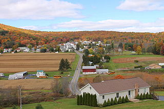
Main Township is a township in Columbia County, Pennsylvania. It is part of Northeastern Pennsylvania. The population was 1,272 at the 2020 census. Main Township was settled in 1772 and incorporated in 1844. The iron industry was once preeminent in the township.

<span class="mw-page-title-main">Washington Township, Erie County, Pennsylvania</span> Township in Pennsylvania, United States

Washington Township is a township in Erie County, Pennsylvania, United States. The population was 4,395 at the 2020 census, down from 4,432 at the 2010 census. The township surrounds the borough of Edinboro.

<span class="mw-page-title-main">Brownsville Township, Fayette County, Pennsylvania</span> Township in Pennsylvania, United States

Brownsville Township is a township in Fayette County, Pennsylvania, United States. The population was 534 at the 2020 census, a decline from the figure of 683 tabulated in 2010. It is served by the Brownsville School District.

<span class="mw-page-title-main">Conyngham Township, Luzerne County, Pennsylvania</span> Township in Pennsylvania

Conyngham Township is a township in Luzerne County, Pennsylvania, United States. The population was 1,309 at the 2020 census.

<span class="mw-page-title-main">Hollenback Township, Luzerne County, Pennsylvania</span> Township in Pennsylvania, United States

Hollenback Township is a township which is located in Luzerne County, Pennsylvania, United States. The population was 1,125 at the time of the 2020 census.

<span class="mw-page-title-main">Hunlock Township, Luzerne County, Pennsylvania</span> Township in Pennsylvania, United States

Hunlock Township is a township in Luzerne County, Pennsylvania, United States. The population was 2,215 at the 2020 census.

<span class="mw-page-title-main">Huntington Township, Luzerne County, Pennsylvania</span> Township in Pennsylvania, United States

Huntington Township is an American township which is in Luzerne County, Pennsylvania. The population was 2,052 at the time of the 2020 census.

<span class="mw-page-title-main">Nescopeck Township, Luzerne County, Pennsylvania</span> Township in Pennsylvania, United States

Nescopeck Township is a township in Luzerne County, Pennsylvania, United States. As of the 2020 census, the township population was 1,080.

<span class="mw-page-title-main">Salem Township, Luzerne County, Pennsylvania</span> Township in Pennsylvania, United States

Salem Township is a township in Luzerne County, Pennsylvania, United States. The population was 4,019 at the 2020 census. The Susquehanna Steam Electric Station, a nuclear power plant, is located in Salem.

<span class="mw-page-title-main">Sugarloaf Township, Luzerne County, Pennsylvania</span> Township in Pennsylvania, United States

Sugarloaf Township is a townshipthat is located in Luzerne County, Pennsylvania, United States. The population was 3,879 at the time of the 2020 census.

<span class="mw-page-title-main">Union Township, Luzerne County, Pennsylvania</span> Township in Pennsylvania, United States

Union Township is a township in Luzerne County, Pennsylvania, United States. The population was 2,033 at the 2020 census.

<span class="mw-page-title-main">Keating Township, Potter County, Pennsylvania</span> Township in Pennsylvania, United States

Keating Township is a township in Potter County, Pennsylvania, United States. The population was 289 at the 2020 census.

<span class="mw-page-title-main">Pleasant Valley Township, Potter County, Pennsylvania</span> Township in Pennsylvania, United States

Pleasant Valley Township is a township in Potter County, Pennsylvania, United States. The population was 76 at the 2020 census.

<span class="mw-page-title-main">East Norwegian Township, Schuylkill County, Pennsylvania</span> Township in Pennsylvania, United States

East Norwegian Township is a township in Schuylkill County, Pennsylvania, United States. The population was 864 at the 2020 census.

<span class="mw-page-title-main">Nuremberg, Pennsylvania</span> Census-designated place in Pennsylvania, United States

Nuremberg is a census-designated place (CDP) that is located in Schuylkill and Luzerne counties, Pennsylvania, United States. The population was 434 at the time of the 2010 census.

References

  1. "2016 U.S. Gazetteer Files". United States Census Bureau. Retrieved August 14, 2017.
  2. 1 2 3 4 Bureau, US Census. "City and Town Population Totals: 2020—2021". Census.gov. US Census Bureau. Retrieved August 1, 2022.
  3. 1 2 "Black Creek Township".
  4. "U.S. Census website". United States Census Bureau . Retrieved January 31, 2008.

41°01′00″N76°09′59″W / 41.01667°N 76.16639°W / 41.01667; -76.16639