Buck Township, Luzerne County, Pennsylvania

Last updated

Buck Township, Pennsylvania
Buck TWP Municipal Building LuzCo PA.jpg
Municipal Building
Map of Luzerne County, Pennsylvania Highlighting Buck Township.PNG
Map of Luzerne County highlighting Buck Township
Map of Pennsylvania highlighting Luzerne County.svg
Map of Pennsylvania highlighting Luzerne County
Country United States
State Pennsylvania
County Luzerne
Area
[1]
  Total16.80 sq mi (43.52 km2)
  Land16.75 sq mi (43.39 km2)
  Water0.05 sq mi (0.13 km2)
Population
 (2020) [2]
  Total378 Decrease2.svg
  Estimate 
(2021) [2]
381
  Density25.61/sq mi (9.89/km2)
Time zone UTC-5 (Eastern (EST))
  Summer (DST) UTC-4 (EDT)
FIPS code 42-079-09760
Website bucktownship.org

Buck Township is a township in Luzerne County, Pennsylvania, United States. As of the 2020 census, the population was 378, [2] making it the least populous township in the county.

Contents

History

The area was first settled in the 1780s by John Nagle. The first sawmill was erected in 1806 by Hugh Conner. Many more sawmills were constructed in the area throughout the 19th century. John Stoddart established the hamlet of Stoddartsville in 1815. The following year (in 1816), he constructed the first church in the village. [3] The Stoddartsville Historic District was added to the National Register of Historic Places in 1998. [4]

Buck Township was formed from Covington Township is 1833. The new township was named after one of its early settlers — George Buck. [3]

Geography

According to the United States Census Bureau, the township has a total area of 17.0 square miles (44 km2), of which 16.9 square miles (44 km2) is land and 0.1 square miles (0.26 km2) (0.29%) is water.

The community is sparsely populated; thick forests cover most of Buck Township. PA 115 is the only major highway in the municipality. Buck is drained by the Lehigh River, which forms its natural southeastern boundary with Monroe County. It has a warm-summer humid continental climate (Dfb) and the hardiness zones are 5a and 5b. Average monthly temperatures in Stoddartsville range from 22.6 °F in January to 68.3 °F in July.

Demographics

Historical population
CensusPop.Note
2010 435
2020 378−13.1%
2021 (est.)381 [2] 0.8%

As of the census [5] of 2010, there were 435 people, 178 households, and 120 families living in the township. The population density was 25.7 people per square mile (10/km2). There were 259 housing units at an average density of 15.3/sq mi (6/km2). The racial makeup of the township was 97% White, 1.6% Black, 0.2% American Indian, 0.7% Asian, 0.5% two or more races.

There were 178 households, out of which 20.2% had children under the age of 18 living with them, 53.9% were married couples living together, 7.9% had a female householder with no husband present, and 32.6% were non-families. 25.8% of all households were made up of individuals, and 7.8% had someone living alone who was 65 years of age or older. The average household size was 2.44 and the average family size was 2.95.

In the township the population was spread out, with 17% under the age of 18, 68.1% from 18 to 64, and 14.9% who were 65 years of age or older. The median age was 45.7 years.

The median income for a household in the township was $35,556, and the median income for a family was $37,813. Males had a median income of $32,361 versus $21,875 for females. The per capita income for the township was $15,123. About 3.4% of families and 7.1% of the population were below the poverty line, including 8.0% of those under age 18 and 14.6% of those age 65 or over.

Related Research Articles

<span class="mw-page-title-main">Paradise, Pennsylvania</span> Census-designated place in Pennsylvania, United States

Paradise is an unincorporated community and census-designated place (CDP) in Lancaster County, Pennsylvania, United States, with a ZIP code of 17562. The population was 1,129 at the 2010 census.

Clyde Township is a civil township of Allegan County in the U.S. state of Michigan. The population was 2,084 at the 2010 census.

Stronach Township is a civil township of Manistee County in the U.S. state of Michigan. The population was 821 at the 2010 census.

Wheatland Township is a civil township of Sanilac County in the U.S. state of Michigan. The population was 416 at the 2020 census.

Girard Township is a township in Otter Tail County, Minnesota, United States. The population was 697 at the 2000 census.

Paddock Township is a township in Otter Tail County, Minnesota, United States. The population was 323 at the 2000 census.

<span class="mw-page-title-main">Cridersville, Ohio</span> Village in Ohio, United States

Cridersville is a village in Auglaize County, Ohio, United States. The population was 1,791 at the 2020 census. It is included in the Wapakoneta, Ohio Micropolitan Statistical Area.

<span class="mw-page-title-main">Beech Creek Township, Clinton County, Pennsylvania</span> Township in Pennsylvania, United States

Beech Creek Township is a township in Clinton County, Pennsylvania, United States. The population was 966 at the 2020 census.

<span class="mw-page-title-main">Beaver Township, Columbia County, Pennsylvania</span> Township in Pennsylvania, United States

Beaver Township is a township in Columbia County, Pennsylvania. It is part of Northeastern Pennsylvania. The population was 879 at the 2020 census. Beaver Township is named for Beaver Run, a tributary of Catawissa Creek, both of which run through the township.

<span class="mw-page-title-main">Bear Creek Township, Luzerne County, Pennsylvania</span> Township in Pennsylvania, United States

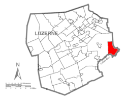
Bear Creek Township is a township in Luzerne County, Pennsylvania, United States. The township has a total area of 67.8 square miles (176 km2), making it is the largest municipality in Luzerne County. The population was 2,752 at the 2020 census.

<span class="mw-page-title-main">Dorrance Township, Luzerne County, Pennsylvania</span> Township in Pennsylvania, United States

Dorrance Township is a township in Luzerne County, Pennsylvania, United States. The population was 2,077 at the 2020 census.

<span class="mw-page-title-main">Jackson Township, Luzerne County, Pennsylvania</span> Township in Pennsylvania, United States

Jackson Township is a township in Luzerne County, Pennsylvania, United States. It is part of the Back Mountain, a 118 square mile region in northern Luzerne County. The population was 4,761 as of the 2020 census.

<span class="mw-page-title-main">Rice Township, Luzerne County, Pennsylvania</span> Township in Pennsylvania, United States

Rice Township is a township in Luzerne County, Pennsylvania, United States. The population was 3,626 at the 2020 census.

<span class="mw-page-title-main">Slocum Township, Luzerne County, Pennsylvania</span> Township in Pennsylvania, United States

Slocum Township is a township in Luzerne County, Pennsylvania, United States. The population was 1,053 at the 2020 census.

<span class="mw-page-title-main">Wright Township, Luzerne County, Pennsylvania</span> Township in Pennsylvania, United States

Wright Township is a township in Luzerne County, Pennsylvania, United States. The population was 5,726 at the 2020 census.

<span class="mw-page-title-main">Springfield Township, Mercer County, Pennsylvania</span> Township in Pennsylvania, United States

Springfield Township is a second-class township in Mercer County, Pennsylvania, United States. The population was 1,855 at the 2020 census, a decrease from 1,981 in 2010.

<span class="mw-page-title-main">Foster Township, Schuylkill County, Pennsylvania</span> Township in Pennsylvania, United States

Foster Township is a township in Schuylkill County, Pennsylvania, United States. The population was 242 at the 2020 census.

<span class="mw-page-title-main">Middletown Township, Susquehanna County, Pennsylvania</span> Township in Pennsylvania, United States

Middletown Township is a township in Susquehanna County, Pennsylvania, United States. The population was 283 at the 2020 census.

<span class="mw-page-title-main">Mineral Township, Venango County, Pennsylvania</span> Township in Pennsylvania, United States

Mineral Township is a township in Venango County, Pennsylvania, United States. The population was 497 at the 2020 census, a decrease from 538 in the 2010 census, which was, in turn, a gain over the 533 residents tabulated in 2000.

<span class="mw-page-title-main">Daniels, West Virginia</span> Census-designated place in West Virginia, United States

Daniels is a census-designated place (CDP) in Raleigh County, West Virginia, United States. The population was 1,881 at the 2010 census.

References

  1. "2016 U.S. Gazetteer Files". United States Census Bureau. Retrieved August 14, 2017.
  2. 1 2 3 4 Bureau, US Census. "City and Town Population Totals: 2020—2021". Census.gov. US Census Bureau. Retrieved August 1, 2022.
  3. 1 2 "Buck Township".
  4. "National Register Information System". National Register of Historic Places . National Park Service. July 9, 2010.
  5. "U.S. Census website". United States Census Bureau . Retrieved May 14, 2011.

41°07′29″N75°39′14″W / 41.12472°N 75.65389°W / 41.12472; -75.65389