Bloomer, Wisconsin | |
---|---|
Coordinates: 45°6′8″N91°29′30″W / 45.10222°N 91.49167°W | |
Country | United States |
State | Wisconsin |
County | Chippewa |
Government | |
• Mayor | James Koehler [1] |
Area | |
• Total | 3.10 sq mi (8.03 km2) |
• Land | 2.95 sq mi (7.64 km2) |
• Water | 0.15 sq mi (0.39 km2) |
Elevation | 994 ft (303 m) |
Population | |
• Total | 3,683 |
• Density | 1,200/sq mi (460/km2) |
Time zone | UTC-6 (Central (CST)) |
• Summer (DST) | UTC-5 (CDT) |
Area codes | 715 & 534 |
FIPS code | 55-08225 [5] |
GNIS feature ID | 1561930 [3] |
Website | ci |
Bloomer is a city in Chippewa County, Wisconsin, United States. As of the 2020 census, the population of the city of Bloomer was 3,683.
Mr. Bloomer and a group of men from Galena, Illinois built a mill on the site in 1848. As winter approached, he sold the dam to H. S. Allen and returned to Galena. Settled in 1855, the village was known as Vanville until 1867, when it was surveyed and platted. [6]
According to the United States Census Bureau, the city has a total area of 3.09 square miles (8.00 km2), of which 2.94 square miles (7.61 km2) is land and 0.15 square miles (0.39 km2) is water. [7]
Bloomer is along U.S. Highway 53 and Wisconsin Highway 40; and also County Roads F, Q, and SS. Wisconsin Highway 64 is nearby.
Climate data for Bloomer, Wisconsin (1991–2020 normals, extremes 1944–present) | |||||||||||||
---|---|---|---|---|---|---|---|---|---|---|---|---|---|
Month | Jan | Feb | Mar | Apr | May | Jun | Jul | Aug | Sep | Oct | Nov | Dec | Year |
Record high °F (°C) | 51 (11) | 60 (16) | 81 (27) | 90 (32) | 94 (34) | 99 (37) | 103 (39) | 104 (40) | 95 (35) | 88 (31) | 75 (24) | 62 (17) | 104 (40) |
Mean daily maximum °F (°C) | 21.3 (−5.9) | 26.4 (−3.1) | 39.1 (3.9) | 54.2 (12.3) | 67.7 (19.8) | 77.2 (25.1) | 81.4 (27.4) | 79.1 (26.2) | 71.0 (21.7) | 56.4 (13.6) | 40.3 (4.6) | 27.0 (−2.8) | 53.4 (11.9) |
Daily mean °F (°C) | 12.4 (−10.9) | 16.4 (−8.7) | 29.2 (−1.6) | 43.5 (6.4) | 56.5 (13.6) | 66.4 (19.1) | 70.5 (21.4) | 68.1 (20.1) | 59.7 (15.4) | 46.0 (7.8) | 32.1 (0.1) | 19.1 (−7.2) | 43.3 (6.3) |
Mean daily minimum °F (°C) | 3.4 (−15.9) | 6.5 (−14.2) | 19.4 (−7.0) | 32.7 (0.4) | 45.4 (7.4) | 55.6 (13.1) | 59.6 (15.3) | 57.0 (13.9) | 48.4 (9.1) | 35.6 (2.0) | 23.9 (−4.5) | 11.2 (−11.6) | 33.2 (0.7) |
Record low °F (°C) | −43 (−42) | −36 (−38) | −36 (−38) | 2 (−17) | 18 (−8) | 30 (−1) | 41 (5) | 34 (1) | 22 (−6) | 6 (−14) | −18 (−28) | −35 (−37) | −43 (−42) |
Average precipitation inches (mm) | 1.00 (25) | 0.94 (24) | 1.58 (40) | 2.93 (74) | 3.73 (95) | 4.51 (115) | 4.14 (105) | 3.98 (101) | 3.32 (84) | 2.82 (72) | 1.74 (44) | 1.22 (31) | 31.91 (811) |
Average snowfall inches (cm) | 9.3 (24) | 9.9 (25) | 7.2 (18) | 2.4 (6.1) | 0.3 (0.76) | 0.0 (0.0) | 0.0 (0.0) | 0.0 (0.0) | 0.0 (0.0) | 0.6 (1.5) | 2.6 (6.6) | 9.5 (24) | 41.8 (106) |
Average precipitation days (≥ 0.01 in) | 8.3 | 6.3 | 7.7 | 10.9 | 12.1 | 12.2 | 10.1 | 9.4 | 10.2 | 9.9 | 6.9 | 8.6 | 112.6 |
Average snowy days (≥ 0.1 in) | 4.5 | 3.6 | 2.5 | 1.0 | 0.1 | 0.0 | 0.0 | 0.0 | 0.0 | 0.3 | 1.4 | 4.5 | 17.9 |
Source: NOAA [8] [9] |
Census | Pop. | Note | %± |
---|---|---|---|
1880 | 304 | — | |
1890 | 631 | 107.6% | |
1900 | 811 | 28.5% | |
1910 | 1,204 | 48.5% | |
1920 | 1,648 | 36.9% | |
1930 | 1,865 | 13.2% | |
1940 | 2,204 | 18.2% | |
1950 | 2,556 | 16.0% | |
1960 | 2,834 | 10.9% | |
1970 | 3,143 | 10.9% | |
1980 | 3,342 | 6.3% | |
1990 | 3,085 | −7.7% | |
2000 | 3,347 | 8.5% | |
2010 | 3,539 | 5.7% | |
2020 | 3,683 | 4.1% | |
WI Counties 1900–1990 |
As of the census [10] of 2010, there were 3,539 people, 1,562 households, and 932 families living in the city. The population density was 1,203.7 inhabitants per square mile (464.8/km2). There were 1,656 housing units at an average density of 563.3 per square mile (217.5/km2). The racial makeup of the city was 97.9% White, 0.3% African American, 0.2% Native American, 0.3% Asian, 0.3% from other races, and 1.0% from two or more races. Hispanic or Latino people of any race were 0.8% of the population.
There were 1,562 households, of which 28.1% had children under the age of 18 living with them, 46.9% were married couples living together, 9.7% had a female householder with no husband present, 3.1% had a male householder with no wife present, and 40.3% were non-families. 34.5% of all households were made up of individuals, and 17.4% had someone living alone who was 65 years of age or older. The average household size was 2.25 and the average family size was 2.89.
The median age in the city was 40.2 years. 23.1% of residents were under the age of 18; 8.2% were between the ages of 18 and 24; 24% were from 25 to 44; 25.8% were from 45 to 64; and 19% were 65 years of age or older. The gender makeup of the city was 47.0% male and 53.0% female.
As of the census [5] of 2000, there were 3,347 people, 1,424 households, and 901 families living in the city. The population density was 1,246.0 people per square mile (480.4/km2). There were 1,487 housing units at an average density of 553.6 per square mile (213.4/km2). The racial makeup of the city was 99.13% White, 0.06% Black or African American, 0.27% Native American, 0.09% Asian, 0.06% from other races, and 0.39% from two or more races. 0.33% of the population were Hispanic or Latino of any race.
There were 1,424 households, out of which 27.8% had children under the age of 18 living with them, 53.7% were married couples living together, 7.3% had a female householder with no husband present, and 36.7% were non-families. 32.2% of all households were made up of individuals, and 16.6% had someone living alone who was 65 years of age or older. The average household size was 2.31 and the average family size was 2.92.
In the city, the population was spread out, with 24.0% under the age of 18, 8.1% from 18 to 24, 26.6% from 25 to 44, 20.7% from 45 to 64, and 20.6% who were 65 years of age or older. The median age was 39 years. For every 100 females, there were 88.4 males. For every 100 females age 18 and over, there were 83.4 males.
The median income for a household in the city was $42,635, and the median income for a family was $57,974.
Bloomer High School is the local high school (9–12). Bloomer Middle School is the local middle school (5–8) and Bloomer Elementary School is the local elementary school (4k-4).
Saint Paul's Catholic School is the local private Catholic school (5k-8).
St. Paul Lutheran School is a Christian Pre-K-8 school of the Wisconsin Evangelical Lutheran Synod in Bloomer. [11]
Bloomer hosts an annual jump rope competition [12] and has been called the "jump rope capital of the world", [13] a title it earned after being featured on national television. [14]
Milford is a town in Van Buren Township, Kosciusko County, in the U.S. state of Indiana. The population was 1,614 at the 2020 census.
Galesburg is a city in Kalamazoo County in the U.S. state of Michigan. The population was 2,049 at the 2020 census.
Bloomer Township is a civil township of Montcalm County in the U.S. state of Michigan. As of the 2020 census, the township population was 6,352, up from a population of 3,904 in the 2010 census.
Laingsburg is a city in Shiawassee County in the U.S. state of Michigan. The population was 1,424 at the 2020 census.
Bloomer Township is a township in Marshall County, Minnesota, United States. The population was 92 at the 2000 census.
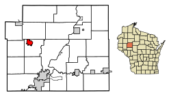
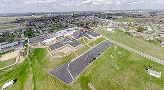
Poynette is a village in Columbia County, Wisconsin, United States. The population was 2,590 at the 2020 census. It is part of the Madison Metropolitan Statistical Area.
Fairwater is a village in Fond du Lac County, Wisconsin, United States. The population was 346 at the 2020 census. The town of Metomen surrounds the village.
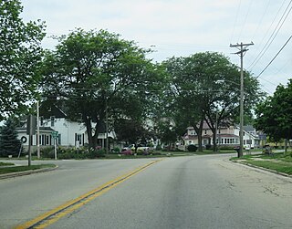
Markesan is a city in Green Lake County, Wisconsin, United States. The population was 1,377 at the 2020 census. The center of population of Wisconsin is located in Markesan.
Galesville is a city in Trempealeau County, Wisconsin, United States. The population was 1,662 at the 2020 census. A dam on Beaver Creek is located at Galesville, forming Lake Marinuka north of the city. The mayor is Vince Howe.
Westby is a city in Vernon County, Wisconsin, United States. The population was 2,332 as of the 2020 census. The name "Westby" is a Norwegian name and literally translates to "Western city".
Slinger is a village in Washington County, Wisconsin, United States. The population was 5,992 at the 2020 census, and Slinger is on the outer edge of the Milwaukee Metropolitan Area
New Auburn is a village in Barron and Chippewa counties in the U.S. state of Wisconsin. The population was 562 at the 2020 census. Of these, 537 were in Chippewa County, and 25 were in Barron County. The village is located mostly within the Town of Auburn in Chippewa County. Small portions extend east into the adjacent Town of Bloomer, Chippewa County and north into the Town of Dovre in Barron County.
Chetek is a city in Barron County, Wisconsin, United States. The population was 2,172 at the 2020 census, down from 2,221 at the 2010 census. The city is located partially within the Town of Chetek.
Brillion is a city in Calumet County, Wisconsin, United States. The population was 3,262 as of the 2020 census. The city is located within the Town of Brillion, though it is politically independent.
Bloomer is a town in Chippewa County in the U.S. state of Wisconsin. The population was 1,050 at the 2010 census, up from 926 at the 2000 census. The city of Bloomer is also located in Chippewa County, but to the south of the town within the adjacent town of Woodmohr.
Colby is a city in Clark and Marathon counties in the U.S. state of Wisconsin. It is part of the Wausau, Wisconsin Metropolitan Statistical Area. The population was 1,852 at the 2010 census. Of this, 1,354 were in Clark County, and 498 were in Marathon County. The city is bordered by the Town of Colby, the Town of Hull, and the City of Abbotsford. Colby cheese was first created in Colby.
Arena is a village in Iowa County, Wisconsin, United States. The population was 844 at the 2020 census. The village is located within the Town of Arena. It is part of the Madison Metropolitan Statistical Area.
Gillett is a city in Oconto County, Wisconsin, United States. The population was 1,386 at the 2010 census. It is part of the Green Bay metropolitan area. The city is adjacent to the Town of Gillett.
Delafield is a city in Waukesha County, Wisconsin, United States, along the Bark River. The population was 7,185 at the 2020 census. It is part of the Milwaukee metropolitan area.
Rockbridge Township is one of thirteen townships in Greene County, Illinois, USA. As of the 2020 census, its population was 1,562 and it contained 715 housing units.