
Berks County is a county located in the U.S. commonwealth of Pennsylvania. As of the 2010 census, the population was 411,442. The county seat is Reading.

Bernville is a borough in Berks County, Pennsylvania, United States. The population was 955 at the 2010 census. Bernville is bordered by Penn Township to the north, east, and south and by Jefferson Township to the west.

Lower Heidelberg Township is a township in Berks County, Pennsylvania, United States. The population was 5,513 at the 2010 census.

North Heidelberg Township is a township in Berks County, Pennsylvania, United States. The population was 1,214 at the 2010 census.

Spring Township is a township in Berks County, Pennsylvania, USA. The population was 27,119 at the 2010 census, making it the second most populous municipality in Berks County after the city of Reading.

Upper Bern Township is a township in Berks County, Pennsylvania, United States. The population was 1,734 at the 2010 census.

Lynn Township is a township in Lehigh County, Pennsylvania, in the United States. It is a suburb of Allentown, in the Lehigh Valley region of the state. The largest township by area in Lehigh County, it is the most rural and least densely populated township in the county.

Tulpehocken Creek is a 39.5-mile-long (63.6 km) tributary of the Schuylkill River in southeastern Pennsylvania in the United States, and during the American Canal Age, once provided nearly half the length of the Union Canal linking the port of Philadelphia, the largest American city and the other communities of Delaware Valley with the Susquehanna basin and the Pennsylvania Canal System connecting the Eastern seaboard to Lake Erie and the new settlements of the Northwest Territory via the Allegheny}, Monongahela. and Ohio Rivers at Pittsburgh.
Dingmans Ferry is an unincorporated community in Delaware Township, Pike County, Pennsylvania, United States. As of 2014, it had a population of 7,477 people. It was originally sited on the Delaware River, in an area now included in the Delaware Water Gap National Recreation Area. When the Corps of Engineers acquired the land by eminent domain in the mid-twentieth century for the creation of the proposed Tocks Island Dam project, it relocated the community further up the hill.

The Delaware Water Gap National Recreation Area is a 70,000 acres (28,000 ha) protected area designated by the National Recreation Area administered by the U.S. Department of the Interior's National Park Service. It is located along the middle section of the Delaware River in New Jersey and Pennsylvania stretching from the Delaware Water Gap northward in New Jersey to the state line near Port Jervis, New York, and in Pennsylvania to the outskirts of Milford. A 40-mile (64 km) section of the Delaware River, entirely within the National Recreation Area, has been granted protected status as the Middle Delaware National Scenic River under the National Wild and Scenic Rivers System and is also administered by the National Park Service. This section of the river is the core of the historical Minisink region.

Pennsylvania Route 183 (PA 183) is a 31.7-mile-long (51.0 km) route that runs north to south in southeastern Pennsylvania. The southern terminus is at U.S. Route 422 Business in Reading in Berks County. Its northern terminus is at PA 61 near Schuylkill Haven in Schuylkill County. The road passes through developed areas near Reading before continuing north through rural areas, crossing from Berks County into Schuylkill County at Blue Mountain. PA 183 serves the communities of Bernville, Strausstown, and Cressona.
Pennsylvania's 17th congressional district is represented by Democrat Conor Lamb. The district encompasses the entirety of Beaver County, a small portion of southwestern Butler County, and all parts of Allegheny County not part of the 18th district.
Pennsylvania State Senate District 29 includes part of Berks County and all of Schuylkill County. More specifically, it includes the following areas:

The Gruber Wagon Works is a historic industrial facility on Red Bridge Road in Bern Township, Pennsylvania, United States. Built about 1882, it is an extremely rare example of a fully outfitted 19th-century wagon manufacturing facility. Originally located in nearby Pleasant Valley, it was moved in 1976 to its present location in Tulpehocken Creek Park to make way for a flood control project. It was designated a National Historic Landmark in 1977. It now serves as part of a county open-air museum.

The 5th Pennsylvania House of Representatives District is in southeastern Pennsylvania and has been represented by Barry Jozwiak since 2014.

Northkill Creek is a stream primarily located in Berks County, Pennsylvania. It feeds into Tulpehocken Creek and covers part of the Schuylkill River and Delaware River watersheds. Northkill Creek and its tributaries are high quality trout streams.
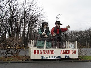
Shartlesville is a census-designated place in Upper Bern Township, Berks County, Pennsylvania. As of the 2010 census, the population was 455 residents.
Old Dry Road, also known as The Staudt Farm, is a historic home and farm complex located in Lower Heidelberg Township, Berks County, Pennsylvania. The farm is located on a branch of Tulpehocken Creek in the Blue Marsh Lake Recreation Area.
The Tulpehocken Creek Historic District is a national historic district located in North Heidelberg Township, and Lower Heidelberg Township, Berks County, Pennsylvania. Encompassing a total of 17,000 acres, this district stretches from the Tulpehocken Creek and Mill Creek at the Berks County-Lebanon County line to the Blue March Dam between Bernville and Millardsville, and is composed of 152 contributing buildings, one contributing site, and four contributing structures which were related to the development which occurred along the upper Tulpehocken Creek from the early 18th century through the late 19th century. Historic buildings located here include early settlement period log cabins, which were built between 1723 and 1750; buildings related to the Charming Forge community, which existed between 1749 and 1895; an early 18th century cemetery and early 19th century church; buildings related to 18th and 19th century farming operations; and structures associated with the development and operation of the Union Canal.
The Pennsylvania State Game Lands Number 280 are Pennsylvania State Game Lands in Berks County in Pennsylvania in the United States providing hunting, bird watching, and other activities.
