Boigu Island (Queensland)

Last updated

Boigu Island
Boigu Island.png
Boigu within the Torres Strait Islands
Australia location map.svg
Red pog.svg
Boigu Island
Boigu Island (Queensland, Australia)
Geography
Location Torres Strait
Coordinates 9°15′34″S142°12′46″E / 9.2594°S 142.2127°E / -9.2594; 142.2127 (Boigu Island (centre of island))
Archipelago Torres Strait Islands
Area89.6 km2 (34.6 sq mi)
Length18.12 km (11.259 mi)
Width5.05 km (3.138 mi)
Highest elevation18 m (59 ft)
Highest pointunnamed
Administration
Australia
State Queensland
LGA Torres Strait Island Region
Island RegionTop Western
Largest settlementBoigu
Demographics
Population199 (2021)
Pop. density3.0/km2 (7.8/sq mi)
Ethnic groups Torres Strait Islanders
Boigu Island
Queensland
Australia Queensland location map.svg
Red pog.svg
Boigu Island
Coordinates 9°15′34″S142°12′46″E / 9.2594°S 142.2127°E / -9.2594; 142.2127
Population199 (2021 census) [1]
 • Density3.002/km2 (7.774/sq mi)
Area66.3 km2 (25.6 sq mi)
Time zone AEST (UTC+10:00)
LGA(s) Torres Strait Island Region
State electorate(s) Cook
Federal division(s) Leichhardt
Localities around Boigu Island:
Bugi (PNG)
Boigu Island
Turnagain Island (QLD)
Church on Boigu beach Church on Boigu beach (undated).jpg
Church on Boigu beach

Boigu Island (also known as Malu Kiyay or Malu Kiwai) is the most northerly inhabited island of Queensland and of Australia. [2] It is part of the Top Western group of the Torres Strait Islands, which lie in the Torres Strait separating Cape York Peninsula from the island of New Guinea. The mainland of Papua New Guinea is only 6 kilometres (3.7 mi) away from Boigu. Boigu has an area of 89.6 square kilometres (34.6 sq mi). Boigu Island is also the name of the town and locality on the island within the Torres Strait Island Region. [3] [4] Boigu is predominantly inhabited by indigenous Torres Strait Islanders. In the 2021 census, the population of the island was 199, of whom 189 people or 95% of the population identified as Indigenous Australians. [1]

Contents

It is the largest and only inhabited island of the Talbot Islands group ( 9°15′33″S142°12′23″E / 9.2591°S 142.2064°E / -9.2591; 142.2064 (Talbot Islands (centre of island group)) ). [5]

Language and affiliations

The language of Boigu is that of the Western and Central Islands of the Torres Strait. The specific dialect is Kalau Kawau Ya, also spoken on the islands of Dauan and Saibai. The people of the three islands consider themselves as one people.

Kala Kawaw Ya (also known as Kalaw Kawaw, KKY) is one of the languages of the Torres Strait. Kala Kawaw Ya is the traditional language owned by the Top Western islands of the Torres Strait Island Region. [6]

Geography

Boigu Island is approximately 18 kilometres (11 mi) long, and low-lying. It was formed by the accumulation of alluvial sediments deposited by the discharge of nearby New Guinean rivers into the Strait. These sediments built up over time on an old coral platform which rises from the shallow continental shelf, eventually creating the island.

The Island is separated from the mainland of Papua New Guinea (near the border of Kiwai Rural LLG and Morehead Rural LLG) by a stretch of water measuring 6 kilometres (3.7 mi) at its narrowest point. The island is also the closest Australian territory to the Republic of Indonesia, just 123 kilometres (76 mi) east-southeast of the southern tip of the Indonesia–Papua New Guinea border within the Merauke Regency of Western New Guinea.[ citation needed ]

The village of Boigu at the northern end of the island ( 9°13′57″S142°13′07″E / 9.2324°S 142.2186°E / -9.2324; 142.2186 (Boigu (village)) ). [7] It is the northernmost settlement of Australia, but the northernmost land is the uninhabited Bramble Cay, 173 kilometres (107 mi) to the east. [8]

Most of the island is subject to extensive periodic flooding, and as a result the community township has been built on the highest ground.[ citation needed ]

There are a number of smaller islands nearby, including:

Boigu Island Airport is on the south-western edge of the village ( 9°13′58″S142°13′05″E / 9.2327°S 142.2181°E / -9.2327; 142.2181 (Boigu Island Airport) ). [12]

History

Boigu was visited by South Sea Islander missionaries of the London Missionary Society, some time after the establishment of a mission on nearby Saibai Island in 1871.[ citation needed ]

From the 1870s to around 1910, the Boigu, Dauan and Saibai people, along with the neighbouring Papuan peoples, were being harassed by thugeral "warriors" from the Marind-anim, fierce headhunters from what is now southeast South Papua. In literature dealing with the period, these people are generally termed 'Tuger' or 'Tugeri'. Sir William MacGregor, the Lieutenant-Governor of British New Guinea, noted in 1886 that the population was nearly extinct as a result of these raids. What he did not realise was that at the time the bulk of the population were staying with family on Saibai and Dauan for mutual protection.[ citation needed ]

According to 2004 Torres Strait Regional Authority (TSRA) figures, its resident population was approximately 340.[ citation needed ]

Malu Kiwai State School opened on 29 January 1985. In 2007, it was one of 17 schools in the Torres Strait Islands that amalgamated, becoming the Malu Kiwai Campus of Tagai State College (which has its main campus on Thursday Island). [13] [14]

In the 2016 census, there were 271 people living on the island, of whom 231 identified as Indigenous Australians (107 male, 124 female). [15]

In the 2021 census, there were 199 people living on the island, of whom 189 identified as Indigenous Australians (84 male, 104 female). [1]

Ecology

The island is considered part of the New Guinea mangroves ecoregion, a subset of the Australasian realm.[ citation needed ]

The interior of the island is sparsely vegetated, and mainly swampland. The coast is fringed by mangroves, which act to protect against the island's sand and mud from sea erosion.[ citation needed ]

It is likely the mangrove regions harbour healthy populations of saltwater crocodile.[ citation needed ]

The waters surrounding the island are an important habitat for dugongs, a species of sea mammal listed as vulnerable by the IUCN.[ citation needed ]

Education

Satellite image of Boigu Island. Boigu Island (Landsat).png
Satellite image of Boigu Island.

The Malu Kiwai Campus of the Tagai State College is a primary (Early Childhood-6) campus of Tagai State College at School Road ( 9°13′52″S142°13′09″E / 9.2310°S 142.2193°E / -9.2310; 142.2193 (Tagai State College - Malu Kiwai Campus) ). [16] [17] [18]

There is no secondary school on the island. The secondary school campus of Tagai State College is on Thursday Island. [19]

Amenities

The Torres Strait Island Regional Council operates an Indigenous Knowledge Centre (library) at 66 Chamber Street ( 9°13′49″S142°13′15″E / 9.2304°S 142.2208°E / -9.2304; 142.2208 (Indigenous Knowledge Centre) ). [20] [21] Partnering with the State Library of Queensland on many occasions over the years, and developed in consultation with the Divisional Manager and Elders on island, the IKC has seen the 2013 Culture Love Program, designed around the theme 'War and Church'. [22] During the project local Elders/Artists were employed to work alongside State Library staff to build their skills in developing and delivering creative arts and language workshops with children and young people in their communities.

With its close proximity to Papua New Guinea, each weekday PNG island traders travel 45 minutes by boat to Boigu Island to sell their products. [22]

Boigu Island Primary Health Care Centre is operated by Queensland Health on Chamber Street ( 9°13′51″S142°13′15″E / 9.2307°S 142.2209°E / -9.2307; 142.2209 (health centre) ). [23] [24]

Boigu Island Sewage Treatment Plant is on the western edge of the village on the Esplanade ( 9°13′54″S142°13′00″E / 9.2317°S 142.2166°E / -9.2317; 142.2166 (sewage treatment plant) ). [23]

See also

Related Research Articles

<span class="mw-page-title-main">Torres Strait</span> Navigable sea passage between Australia and New Guinea

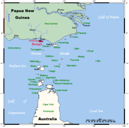
The Torres Strait, also known as Zenadh Kes, is a strait between Australia and the Melanesian island of New Guinea. It is 150 km (93 mi) wide at its narrowest extent. To the south is Cape York Peninsula, the northernmost extremity of the Australian mainland. To the north is the Western Province of Papua New Guinea. It is named after the Spanish navigator Luís Vaz de Torres, who sailed through the strait in 1606.

<span class="mw-page-title-main">Torres Strait Islands</span> Group of islands in the Torres Strait between Australia and New Guinea

The Torres Strait Islands are an archipelago of at least 274 small islands in the Torres Strait, a waterway separating far northern continental Australia's Cape York Peninsula and the island of New Guinea. They span an area of 48,000 km2 (19,000 sq mi), but their total land area is 566 km2 (219 sq mi).

<span class="mw-page-title-main">Torres Strait Islanders</span> One of the two categories of Indigenous Australians

Torres Strait Islanders are the Indigenous Melanesian people of the Torres Strait Islands, which are part of the state of Queensland, Australia. Ethnically distinct from the Aboriginal peoples of the rest of Australia, they are often grouped with them as Indigenous Australians. Today, there are many more Torres Strait Islander people living in mainland Australia than on the Islands.

The Mabuyag are an Indigenous Australian group of Torres Strait Islander people united by a common language, strong ties of kinship and survived as skilled hunter–fisher–gatherers and horticulturalists in family groups or clans living on and around Mabuiag Island, in Torres Strait in Queensland, Australia. They are ethnically Melanesian.

<span class="mw-page-title-main">Horn Island, Queensland</span> Suburb of Shire of Torres, Queensland, Australia

Horn Island, or Ngurupai/Narupai in the local language, is an island of the Torres Strait Islands archipelago located in the Torres Strait, in Queensland in Northern Australia between the Australian mainland and Papua New Guinea. It is within the locality of Horn within the Shire of Torres; the boundaries of the locality include the island itself and surrounding waters of the Torres Strait. The town of Wasaga is on the north-western coast of the island. In the 2021 census, the locality of Horn had a population of 533 people.

<span class="mw-page-title-main">Mabuiag Island</span> Town in Queensland, Australia

Mabuiag, also known as "Mabuyag" and natively "Mabuyaagi", formerly "Jervis Island") is one of the Torres Strait Islands in Queensland, Australia. Mabuiag is also a town and locality in the Torres Strait Island Region local government area. In the 2021 census, the locality of Mabuiag Island had a population of 253 people.

<span class="mw-page-title-main">Saibai Island</span> Suburb of Torres Strait Island Region, Queensland, Australia

Saibai Island, commonly called Saibai, is an island of the Torres Strait Islands archipelago, located in the Torres Strait of Queensland, Australia. The island is situated north of the Australian mainland and south of the island of New Guinea. The island is a locality within the Torres Strait Island Region local government area. The town of Saibai is located on the north-west coast of the island. According to the 2016 census, Saibai Island had a population of 465 people.

<span class="mw-page-title-main">Seisia, Queensland</span> Town in Queensland, Australia

Seisia is a coastal town and a locality in the Northern Peninsula Area Region, Queensland, Australia. In the 2021 census, the locality of Seisia had a population of 293 people.

<span class="mw-page-title-main">Hammond Island (Queensland)</span> Town in Queensland, Australia

Hammond Island is an island with a town of the same name, in the Torres Strait, Queensland, Australia. It is the only island within the locality of Keriri Island within the local government area of Torres Strait Island Region.

<span class="mw-page-title-main">Sue Islet (Queensland)</span> Islet in Queensland, Australia

Sue Islet, also known as Warraber, is the middle islet of The Three Sisters, Torres Strait, Queensland, Australia. This island is one of the Torres Strait Islands and is within the locality of Warraber Islet in the Torres Strait Island Region.

<span class="mw-page-title-main">Coconut Island (Queensland)</span> Town in Queensland, Australia

Coconut Island, Poruma Island, or Puruma in the local language, is an island in the Great North East Channel near Cumberland Passage, Torres Strait, Queensland, Australia. One of the Torres Strait Islands, Coconut Island is 130 kilometres (81 mi) northeast of Thursday Island. Administratively, Coconut Island is a town and Poruma Island is the locality within the Shire of Torres.

<span class="mw-page-title-main">Yam Island</span> Island in Queensland, Australia

Yam Island, called Yama or Iama in the Kulkalgau Ya language or Turtle-backed Island in English, is an island of the Bourke Isles group of the Torres Strait Islands, located in the Tancred Passage of the Torres Strait in Queensland, Australia. The island is situated approximately 100 kilometres (62 mi) northeast of Thursday Island and measures about 2 square kilometres (0.77 sq mi). The island is an official locality known as Iama Island within the local government area of Torres Strait Island Region. The town, also called Yam Island, is located on the north-west coast of the island. In the 2021 census, Iama Island had a population of 275 people.

<span class="mw-page-title-main">Talbot Islands</span>

Talbot Islands are a group of Torres Strait Islands in Queensland, Australia. They lie between the Australian mainland and the island of New Guinea and a few kilometres west of Saibai Island, Torres Strait, only 4 km from the Papua New Guinea mainland at the mouth of the Mai Kussa River.

The Torres Strait Island Region is a local government area in Far North Queensland, Australia, covering part of the Torres Strait Islands. It was created in March 2008 out of 15 autonomous Island Councils during a period of statewide local government reform. It has offices in each of its 15 communities, and satellite services in Thursday Island and in Cairns.

<span class="mw-page-title-main">Holy Trinity Church, Saibai Island</span> Historic site in Queensland, Australia

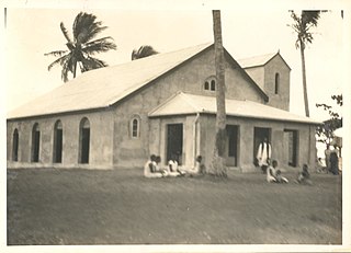
Holy Trinity Church is a heritage-listed Anglican church at Saibai Island, Torres Strait Island Region, Queensland, Australia. It was built from 1917 to 1938. It is also known as Holy Trinity Church of England. It was added to the Queensland Heritage Register on 21 October 1992.

<span class="mw-page-title-main">All Saints Anglican Church, Darnley Island</span> Historic site in Queensland, Australia

All Saints Anglican Church is a heritage-listed church at Darnley Island, Torres Strait Island Region, Queensland, Australia. It was built from 1919 to 1938. It was added to the Queensland Heritage Register on 21 October 1992.

<span class="mw-page-title-main">Dauan Island</span> Town in Queensland, Australia

Dauan Island is an island in the Torres Strait, Queensland, Australia; it is also known as Cornwallis Island. Dauan Island is also a town and locality in the Torres Strait Island Region, Queensland, Australia. In the 2021 census, the locality of Dauan Island had a population of 131 people.

<span class="mw-page-title-main">Masig Island, Queensland</span> Suburb of Torres Strait Island Region, Queensland, Australia

Masig Island is an island and locality in the Torres Strait Island Region, Queensland, Australia. In the 2021 census, Masig Island had a population of 283 people.

Saibai is a town within the locality of Saibai Island in the Torres Strait Island Region, Queensland, Australia.

The Torres Strait Treaty is a treaty signed between Australia and Papua New Guinea. The treaty defined the border between Australia and Papua New Guinea following the latter's independence from Australia in 1975. The treaty also set out the manner in which the common border area would be managed. The treaty was signed in December 1978 and came into effect in 1985.

References

  1. 1 2 3 Australian Bureau of Statistics (28 June 2022). "Boigu Island (SAL)". 2021 Census QuickStats. Retrieved 8 August 2022. OOjs UI icon edit-ltr-progressive.svg
  2. "Boigu Island – island in the Torres Strait Island Region (entry 3484)". Queensland Place Names. Queensland Government . Retrieved 7 August 2022.
  3. "Boigu Island – locality in the Torres Strait Island Region (entry 46701)". Queensland Place Names. Queensland Government . Retrieved 7 August 2022.
  4. "Boigu Island – town in the Torres Strait Island Region (entry 3483)". Queensland Place Names. Queensland Government . Retrieved 7 August 2022.
  5. "Island groups - Queensland". Queensland Open Data. Queensland Government. 12 November 2020. Archived from the original on 25 November 2020. Retrieved 25 November 2020.
  6. CC BY icon-80x15.png This Wikipedia article incorporates CC-BY-4.0 licensed text from: "Indigenous languages map of Queensland". State Library of Queensland. State Library of Queensland . Retrieved 5 February 2020.
  7. "Boigu – population centre in Torres Strait Island Regional (entry 3483)". Queensland Place Names. Queensland Government . Retrieved 7 March 2022.
  8. "Bramble Cay – island in the Shire of Torres (entry 4280)". Queensland Place Names. Queensland Government . Retrieved 7 August 2022.
  9. "Aubussi Island – island (entry 993)". Queensland Place Names. Queensland Government . Retrieved 25 November 2020.
  10. 1 2 3 4 5 "Marine islands - Queensland". Queensland Open Data. Queensland Government. 12 November 2020. Archived from the original on 25 November 2020. Retrieved 25 November 2020.
  11. "Moimi Island – island (entry 22437)". Queensland Place Names. Queensland Government . Retrieved 25 November 2020.
  12. "Airports - Queensland". Queensland Open Data. Queensland Government. 22 October 2020. Archived from the original on 15 November 2020. Retrieved 3 November 2020.
  13. Queensland Family History Society (2010), Queensland schools past and present (Version 1.01 ed.), Queensland Family History Society, ISBN   978-1-921171-26-0
  14. "Principal's welcome". Tagai State College. 19 May 2020. Archived from the original on 21 March 2022. Retrieved 7 August 2022.
  15. Australian Bureau of Statistics (27 June 2017). "Boigu Island". 2016 Census QuickStats. Retrieved 7 August 2022. OOjs UI icon edit-ltr-progressive.svg
  16. "State and non-state school details". Queensland Government. 9 July 2018. Archived from the original on 21 November 2018. Retrieved 21 November 2018.
  17. "Boigu Island - Malu Kiyay Ngurpay Lag". Tagai State College. 21 February 2019. Archived from the original on 3 March 2022. Retrieved 7 August 2022.
  18. "Tagai State College". Tagai State College. 19 May 2020. Archived from the original on 30 August 2012. Retrieved 7 August 2022.
  19. "Queensland Globe". State of Queensland . Retrieved 7 August 2022.
  20. "Boigu". Public Libraries Connect. State Library of Queensland. 28 August 2017. Archived from the original on 31 January 2018. Retrieved 31 January 2018.
  21. "Boigu: An IKC with a point of difference | State Library Of Queensland". www.slq.qld.gov.au. 22 June 2022. Archived from the original on 22 June 2022. Retrieved 7 August 2022.
  22. 1 2 CC BY icon-80x15.png This Wikipedia article incorporates text from Boigu: An IKC with a point of difference (22 June 2022) by Indigenous services published by the State Library of Queensland under CC BY licence , accessed on 18 January 2023.
  23. 1 2 "Landmark Areas - Queensland". Queensland Open Data. Queensland Government. 18 November 2020. Archived from the original on 21 November 2020. Retrieved 21 October 2020.
  24. "Boigu Island Primary Health Care Centre Profile". Queensland Health . Archived from the original on 29 March 2022. Retrieved 7 August 2022.

Further reading