Bonogin, Queensland

Last updated

Bonogin
Gold Coast,  Queensland
Bonogin General Store.jpg
Bonogin General Store, 2012
Gold Coast locator map.svg
Red pog.svg
Bonogin
Bonogin, Queensland
Coordinates 28°08′07″S153°21′30″E / 28.1352°S 153.3583°E / -28.1352; 153.3583 (Bonogin (centre of locality))
Population4,573 (2016 census) [1]
 • Density118.17/km2 (306.0/sq mi)
Postcode(s) 4213
Area38.7 km2 (14.9 sq mi)
Time zone AEST (UTC+10:00)
Location
LGA(s) City of Gold Coast
State electorate(s) Mudgeeraba
Federal division(s)
Suburbs around Bonogin:
Mudgeeraba Mudgeeraba Reedy Creek
Austinville Bonogin Tallebudgera Valley
Austinville Tallebudgera Valley Tallebudgera Valley

Bonogin is a rural hinterland locality in the City of Gold Coast, Queensland, Australia. [2] In the 2016 census, Bonogin had a population of 4,573 people. [1]

Contents

Geography

Bonogin is on the edge of the Gold Coast hinterland. [3] It is about 81 kilometres (50 mi) away from Brisbane. [4]

History

The origin of name is not known, but it is speculated that it is derived from the Aboriginal word Boonoo meaning red bloodwood. [5]

European settlement commenced in the 1870s. The early industries were timber cutting and dairying. Later bananas were grown. [5]

Approval was given to establish a school in 1913. [6] Bonogin Creek State School opened on 7 July 1913. There were closures due to teacher shortages in 1917 and 1921. The school finally closed on 30 March 1924. [5] [7] The school was on Bonogin Road (approx 28°08′34″S153°20′03″E / 28.14291°S 153.33413°E / -28.14291; 153.33413 (Bonogin State School (former)) ). [8] The school building was relocated to Wunburra (near Springbrook) in 1934. [9]

In the 1980s, some of the farms were subdivided to form acreage residential developments. [5]

In the 2011 census, Bonogin had a population of 4,182 people. [10] [4]

In the 2016 census, Bonogin had a population of 4,573 people. [1]

Bonogin Creek

Part of the City of Gold Coast's Beaches to Bushland volunteer restoration program includes Bonogin Creek. The primary tributary of the creek begins in the Gold Coast hinterland. A hinterland regional park bushcare group was established in 1999 to address conservation of local plant species and also attempt to restore natural habitat of the creek. Davenport Park is a suburban park running along a lower point of the creek, within suburban Bonogin. In 2013 Bonogin Valley bushcare group formed to help with restoration of the park and creek area. [11]

Amenities

The Gold Coast City Council operates a fortnightly mobile library service which visits Davenport Park on Bonogin Road East. [12]

Related Research Articles

<span class="mw-page-title-main">Currumbin, Queensland</span> Suburb of Gold Coast, Queensland, Australia

Currumbin is a coastal suburb in the City of Gold Coast, Queensland, Australia. In the 2016 census, Currumbin had a population of 2,920 people.

<span class="mw-page-title-main">Mudgeeraba, Queensland</span> Suburb of Gold Coast, Queensland, Australia

Mudgeeraba is a town and suburb in the City of Gold Coast, Queensland, Australia. In the 2021 census, the suburb of Mudgeeraba had a population of 14,578 people. Mudgeeraba's essential character remains one of a nineteenth-century village.

<span class="mw-page-title-main">Nerang, Queensland</span> Suburb of Gold Coast, Queensland, Australia

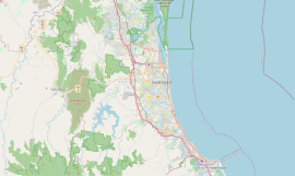
Nerang is a town and suburb in the City of Gold Coast, Queensland, Australia. In the 2016 census, Nerang had a population of 16,864 people.

<span class="mw-page-title-main">Helensvale, Queensland</span> Suburb of Gold Coast, Queensland, Australia

Helensvale is a suburb of the City of Gold Coast in Queensland, Australia. In the 2016 census, Helensvale had a population of 16,862 people.

<span class="mw-page-title-main">Natural Bridge, Queensland</span> Suburb of Gold Coast, Queensland, Australia

Natural Bridge is a rural locality in the City of Gold Coast, Queensland, Australia. It borders New South Wales. In the 2016 census, Natural Bridge had a population of 108 people.

<span class="mw-page-title-main">Varsity Lakes</span> Suburb of Gold Coast, Queensland, Australia

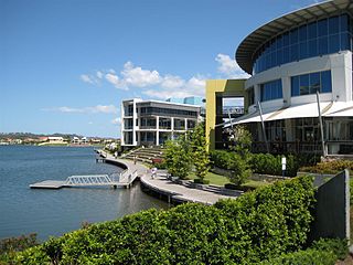
Varsity Lakes is a suburb in the City of Gold Coast, Queensland, Australia. In the 2021 census, Varsity Lakes had a population of 16,493 people.

<span class="mw-page-title-main">Numinbah Valley</span> Suburb of Gold Coast, Queensland, Australia

Numinbah Valley is a rural locality in the City of Gold Coast, Queensland, Australia. In the 2016 census, Numinbah Valley had a population of 218 people.

<span class="mw-page-title-main">Austinville, Queensland</span> Suburb of Gold Coast, Queensland, Australia

Austinville is a hinterland locality in the City of Gold Coast, Queensland, Australia. In the 2021 census, Austinville had a population of 403 people.

<span class="mw-page-title-main">Clagiraba, Queensland</span> Suburb of Gold Coast, Queensland, Australia

Clagiraba is a rural locality in the City of Gold Coast, Queensland, Australia. In the 2021 census, Clagiraba had a population of 651 people.

<span class="mw-page-title-main">Springbrook, Queensland</span> Suburb of Gold Coast, Queensland, Australia

Springbrook is a rural town and locality in the City of Gold Coast, Queensland, Australia. In the 2016 census, the locality of Springbrook had a population of 659 people.

<span class="mw-page-title-main">Coomera, Queensland</span> Town in Queensland, Australia

Coomera is a town and suburb in the City of Gold Coast, Queensland, Australia. In the 2016 census, Coomera had a population of 13,305 people.

<span class="mw-page-title-main">Advancetown, Queensland</span> Suburb of Gold Coast, Queensland, Australia

Advancetown is a rural outer locality in the City of Gold Coast, Queensland, Australia. In the 2021 census, Advancetown had a population of 528 people.

<span class="mw-page-title-main">Gilston, Queensland</span> Suburb of City of Gold Coast, Queensland, Australia

Gilston is a rural residential locality in the City of Gold Coast, Queensland, Australia. In the 2016 census, Gilston had a population of 2,459 people.

<span class="mw-page-title-main">Cedar Creek, Queensland (Logan & Gold Coast)</span> Suburb of City of Gold Coast, Queensland, Australia

Cedar Creek is a locality split between City of Gold Coast and Logan City in Queensland, Australia. In the 2016 census, Cedar Creek had a population of 838 people.

<span class="mw-page-title-main">Currumbin Valley, Queensland</span> Suburb of Gold Coast City, Queensland, Australia

Currumbin Valley is a rural locality in the City of Gold Coast, Queensland, Australia. It borders New South Wales. In the 2021 census, Currumbin Valley had a population of 2,084 people.

Lower Beechmont is a locality in the City of Gold Coast, Queensland, Australia. It is situated in the Gold Coast hinterland. In the 2016 census, Lower Beechmont had a population of 1,046 people.

<span class="mw-page-title-main">Tallebudgera Valley, Queensland</span> Suburb of Gold Coast, Queensland, Australia

Tallebudgera Valley is an outer locality in the City of Gold Coast, Queensland, Australia. It borders New South Wales. In the 2016 census, Tallebudgera Valley had a population of 1624 people.

<span class="mw-page-title-main">Luscombe, Queensland</span> Suburb of Gold Coast City, Queensland, Australia

Luscombe is a rural locality in the City of Gold Coast, Queensland, Australia. In the 2016 census, Luscombe had a population of 307 people.

<span class="mw-page-title-main">Wongawallan, Queensland</span> Suburb of Gold Coast, Queensland, Australia

Wongawallan is a rural locality in the City of Gold Coast, Queensland, Australia. In the 2016 census Wongawallan had a population of 1,273 people.

<span class="mw-page-title-main">Worongary</span> Suburb of Gold Coast City, Queensland, Australia

Worongary is a suburb in the City of Gold Coast, Queensland, Australia. In the 2016 census, Worongary had a population of 5,613 people.

References

  1. 1 2 3 Australian Bureau of Statistics (27 June 2017). "Bonogin (SSC)". 2016 Census QuickStats. Retrieved 20 October 2018. OOjs UI icon edit-ltr-progressive.svg
  2. "Bonogin – locality in City of Gold Coast (entry 46030)". Queensland Place Names. Queensland Government . Retrieved 26 January 2020.
  3. Gold Coast Suburb Guide – Bonogin, QLD, 4213 Archived 6 August 2012 at the Wayback Machine . Retrieved 25 August 2012.
  4. 1 2 Bonogin Demographics (QLD) Local Stats Archived 26 March 2022 at the Wayback Machine . Retrieved 25 August 2012.
  5. 1 2 3 4 "Bonogin History". History of our suburbs. City of Gold Coast Council. Archived from the original on 27 April 2014. Retrieved 26 April 2014.
  6. "CLASSIFICATIONS AND TRANSFERS OF STATE SCHOOL TEACHERS". The Queenslander . National Library of Australia. 29 March 1913. p. 14. Archived from the original on 21 May 2022. Retrieved 27 April 2014.
  7. Queensland Family History Society (2010), Queensland schools past and present (Version 1.01 ed.), Queensland Family History Society, ISBN   978-1-921171-26-0
  8. "Springbrook" (Map). Queensland Government. 1934. Archived from the original on 8 May 2024. Retrieved 8 May 2024.
  9. "PUBLIC WORKS". The Courier-Mail . Brisbane: National Library of Australia. 24 August 1934. p. 23. Archived from the original on 26 January 2021. Retrieved 27 April 2014.
  10. Australian Bureau of Statistics (31 October 2012). "Bonogin (SSC)". 2011 Census QuickStats. Retrieved 26 April 2014. OOjs UI icon edit-ltr-progressive.svg
  11. "Bonogin Bushcare Group". Gold Coast Parks. Archived from the original on 13 November 2013. Retrieved 3 December 2013.
  12. "Mobile Library 2018 timetable" (PDF). Gold Coast City Council . Archived from the original (PDF) on 30 January 2018. Retrieved 30 January 2018.