The Brahmaputra floods refers to a catastrophic flood event that occurred in 2012 along the Brahmaputra River and its tributaries, as well as in subsequent years.
The 2012 Brahmaputra floods were an unprecedented flood event along the Brahmaputra River and its tributaries due to significant monsoon rains in India, Bangladesh and Myanmar. 124 people were killed by the flooding and landslides, and about six million people were displaced. The worst hit area was the state of Assam in India. Flooding significantly affected Kaziranga National Park, where 540 animals died including 16 rhinos.
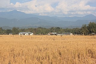
In September 2011, the Brahmaputra River flowed through braided channels, but a year later, the channels could not be detected in the swollen river. During the monsoon season (June–October), floods are a common occurrence in India. Occasionally, massive flooding causes huge losses to crops, life and property. Deforestation in the Brahmaputra watershed has resulted in increased siltation levels, flash floods, and soil erosion in critical downstream habitat, such as the Kaziranga National Park in middle Assam.[1][2][3]
Helicopters were deployed to drop food supplies to nearly 10,000 people in six villages where highway access was cut off by the flooding, about 550km west of [Guwahati]
2013
In 2013, the Brahmaputra River and its tributaries flooded, triggered by heavy rainfall at the end of June in the neighboring state of Arunachal Pradesh state through Brahmaputra river and its tributaries.[4] This series of floods submerged 12 districts out of 27 in the state of Assam, where more than 1,00,000 people were affected.[5][6] The flood also affected Kaziranga National Park and the Pobitora Wildlife Sanctuary where many animals moved to higher ground in order to save themselves from the flood.[7] The floods also affected some of the northern districts of Bangladesh, where 100,000 people suffered from a scarcity of food and pure drinking water.[8]
In which 396 villages affected and around 7000 hectares of agricultural land were destroyed. Many roads and bridges were washed away cutting all road links to rest of the state.[9] Eight relief camps have been set up in Dhemaji and Chirang districts where about 3,000 people have been given shelter. The flood victims claimed there were no river embankments at various places or those breached by earlier floods were not repaired.[10]
2015
Assam flood in 2015
2015 Assam floods were floods in the Indian state of Assam which were triggered by heavy rainfall at the end of August in neighbouring Arunachal Pradesh state through Brahmaputra river and its tributaries. The floods are reported to have caused the deaths of 42 people and numerous landslides, road blockages and affected 16.5 lakh people in 21 districts.[11]
Flooding affected 2,100 villages and destroyed standing crops across an area of 4,40,000 acres.[11][12][13][14] In the Dhubri district alone, more than 400 villages are now almost impossible to reach making it difficult to send aid to the suffering civilians.[15] However, this is not the first time the Assam state has experienced destructive flooding; the region is possibly India's most flood-prone state and has experienced at least 12 major floods since 1950.[16] Although always prone to floods, the frequency of disastrous floods was increased in the area after the 1950 Assam-Tibet earthquake, also referred to as the "1950 Great Earthquake".[16]
The 2016 Assam floods were caused by large rains over the Northeastern Indian state of Assam in July 2016. The flooding had affected 18 lakh people, and flooded the Kaziranga National Park.[17]As of 1August2016[update], 28 people had been killed as a result of the flooding starting 17 July, according to a report by the State Disaster Management Authority.[18]
The floods have affected more than 16 lakh human lives, and people choose to abandon their households and livestock, and escape with help of homemade rafts. Mobile phone networks, along with power transmission, have been hampered in many regions of the state.[17] Around 4,90,000 acres of farming land was affected by the floods.[18] The Assam Branch Indian Tea Association (ABITA) has estimated a 21-30% crop loss of Assam tea. The state of Assam had produced 63.1 crore kg of tea in a year
Officers and local people rescued 100 wild animals, including 9 rhinoceroses.[23] These were taken for treatment at the Centre for Wildlife Rehabilitation and Conservation located within Kaziranga.[22]
Rescue work
About 300 makeshift camps were erected to rehabilitate people displaced by the flooding.[17] Various schools were used as relief camps. National Disaster Response Force took up the relief works.[18] An NGO named "Save the Children" worked for the rehabilitation of children and their families in the three districts of Dhemaji, Lakhimpur and Majuli.[24]
The 2017 Northeast India floods were caused by overflowing of Brahmaputra river in the state of Assam in July 2017 affecting four Indian states: Assam, Arunachal Pradesh, Nagaland and Manipur.[26][27] As of 14 July 2017, at least 85 people were dead[28] as a result of the flooding and 4 lakh people have been affected and 5,00,000 have been homeless.[29] Nearly 60 animals, mostly deer and wild boars, perished in the floods.[30]
The state government of Assam set up 128 relief camps under the surveillance of Assam Chief MinisterSarbananda Sonowal for people displaced, and has made arrangements for drinking water, food and medical teams and rescue goods. 154 people died due to drowning, electrocution and diseases caused due to water contamination.
Government has provided health and medical facilities in the state.[33]
2018
The 2018 Floods in the Tributaries of the Brahmaputra affected 4.5 lakh people across the districts of Dhemaji, Barpeta, Lakhimpur, Biswanath, Majuli and Dibrugarh in the state of Assam. According to the Assam State Disaster Management Authority (ASDMA), total 12 persons lost their lives in the first wave of flood in the year. The floods inundated 11,243 hectares of agricultural lands with standing crops in four districts.[34]
In 2020, floods were caused due to heavy rain in Assam and rising level of water in Brahmaputra.[38] More than 30,000 were affected across 5 districts and crops were destroyed.[39] The floods also coincided with the ongoing COVID-19 pandemic in India in Assam.
Till July, the floods along with landslides affected 1.6 million people in 22 districts of Assam and casualties rising to 33.[40][41] 2 people died in Arunachal Pradesh due to landslide.[42] Around 2,200 villages were under water and 87,000 hectares of crop area was damaged, The water level was above danger mark in several cities.[43] More than 50 percent of the area of Kaziranga National Park and Pobitora Wildlife Sanctuary are affected by floods forcing animals to move to other places.[44]
The floods in May, 2022 were caused due to above normal rainfall across the state.[45] As of 25th May, more than 6 lakh people were affected and 25 have lost their lives.[46][47] According to Assam State Disaster Management Authority (ASDMA), thousands of villages and more than 60,000 hectares (600km2) of crop area have been affected across the state. Authorities are running several relief camps and distribution centres across the state sheltering thousands of people.[48]
Railway lines were also affected due to flooding and landslides.[49]
Related Research Articles
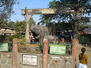
Kaziranga National Park is a national park in the Golaghat, Sonitpur, Biswanath andNagaon districts of the state of Assam, India. KNP has 5 ranges. The park, which hosts two-thirds of the world's Indian rhinoceroses, is a UNESCO World Heritage Site. According to a March 2018 census conducted jointly by the Forest Department of the Government of Assam and some recognized wildlife NGOs, the rhino population in Kaziranga National Park is 2,613. It comprises 1,641 adult rhinos and 385 calves.
Lakhimpur district is an administrative district in the state of Assam in India. The district headquarter is located at North Lakhimpur. The district is bounded on the North by Siang and Papumpare districts of Arunachal Pradesh and on the East by Dhemaji District and Subansiri River. Majuli District stands on the Southern side and Biswanath District is on the West.
Nagaon district is an administrative district in the Indian state of Assam. At the time of the 2011 census it was the most populous district in Assam, before Hojai district was split from it in 2016.
Dhemaji is a small town and the headquarters of the Dhemaji district in the state of Assam, India. It is situated on the north bank of the Brahmaputra River and serves as an important administrative and commercial centre for the surrounding area.The town is known for its serene environment, traditional Assamese culture, and proximity to natural attractions like hills, rivers and forests.
Dhemaji district is an administrative district in the state of Assam in India. The district headquarters are located in Dhemaji and commercial headquarters are located in Silapathar. Dhemaji covers an area of 3,237 km2 and has a population of 686,133. The predominant religion is Hinduism, with Hindus comprising approximately 95.47% of the population.
This article discusses the geological origin, geomorphic characteristics, and climate of the northeastern Indian state of Assam. Extending from 89° 42′ E to 96° E longitude and 24° 8′ N to 28° 2′ N latitude, it has an area of 78,438 km2, similar to that of Ireland or Austria.
The history of Kaziranga National Park in the Golaghat and Nagaon districts of the state of Assam, India, can be traced back to the beginning of the twentieth century, in 1904. It now is a World Heritage Site and hosts two-thirds of the world's Great One-horned Rhinoceroses, tigers, and many other endangered animals.
Kohora is a small town situated in the Golaghat district of Assam. It is the main entrance of the world-famous Kaziranga National Park. It lies on the National Highway 37(Asean Highway 1). Kohora Lies Between Nagaon And Golaghat.
Kaziranga National Park is an Indian national park and a World Heritage Site in Golaghat and Nagaon districts of Assam, India. It is refuge for the world's largest population of Great One-horned Rhinoceros. The park has many elephant, water buffalo and swamp deer. It is recognized as an Important Bird Area by BirdLife International for conservation of avifaunal species. The park has achieved notable progress in wildlife conservation despite several constraints.
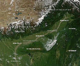
Assam is the main and oldest state in the North-East Region of India and as the gateway to the rest of the Seven Sister States. The land of red river and blue hills, Assam comprises three main geographical areas: the Brahmaputra Valley which stretching along the length of the Brahmaputra river, the Barak Valley extending like a tail, and the intervening Karbi Plateau and North Cachar Hills. Assam shares its border with Meghalaya, Arunachal Pradesh, Nagaland, Manipur, Tripura, Mizoram and West Bengal; and there are National Highways leading to their capital cities. It also shares international borders with Bhutan and Bangladesh and is very close to Myanmar. In ancient times Assam was known as Pragjyotisha or Pragjyotishpura, and Kamarupa.
The 2007 South Asian floods were a series of floods in India, Pakistan, Bhutan, Nepal and Bangladesh. News Agencies, citing the Indian and Bangladeshi governments, place the death toll in excess of 2,000. By 3 August, approximately 20 million had been affected and by 10 August some 30 million people in India, Bangladesh and Nepal had been affected by flooding.
The 2008 Indian floods were a series of floods in various states of India during the 2008 monsoon season. The floods mostly affected the western regions of Maharashtra state and Andhra Pradesh as well as northern Bihar. In India, the monsoon season generally lasts from June to September.
The National Disaster Response Force (NDRF) is an Indian specialised force constituted under the Disaster Management Act, 2005.
This is a list of notable recorded floods that have occurred in India. Floods are the most common natural disaster in India. The heaviest southwest, the Brahmaputra, and other rivers to distend their banks, often flooding surrounding areas.
Assam – 16th largest, 15th most populous and 26th most literate state of the 28 states of the democratic Republic of India. Assam is at 14th position in life expectancy and 8th in female-to-male sex ratio. Assam is the 21st most media exposed states in India. The Economy of Assam is largely agriculture based with 69% of the population engaged in it. Growth rate of Assam's income has not kept pace with that of India's during the Post-British Era; differences increased rapidly since the 1970s. While the Indian economy grew at 6 percent per annum over the period of 1981 to 2000, the same of Assam's grew only by 3.3 percent.
The 2019 Indian floods were a series of floods that affected over thirteen states in late July and early August 2019, due to excessive rains. At least 200 people died and about a million people were displaced. Karnataka and Maharashtra were the most severely affected states. People died but many were rescued with the help of the Indian Navy.
2020 Assam floods refers to the significant flood event of the Brahmaputra River in the Indian north-eastern state of Assam and coincided with the COVID-19 pandemic. Initial flooding started in May 2020 due to heavy rainfall affecting 30,000 and destroying crops across 5 districts. As of October 2020 the floods affected over five million people, claiming the lives of 123 people, with an additional 26 deaths due to landslides, 5474 villages were affected and over one hundred and fifty thousand people found refuge in relief camps.
Beginning in May 2022, deadly floods hit northeastern India and Bangladesh. Over 9 million people in both countries have been affected, and around 300 people were killed.
Heavy rainfall during the 2024 monsoon season resulted in severe flooding and landslides across several regions of India. Rainfall caused significant flooding first in Assam State and later end of August also in Gujarat, India.
References
↑ Das, D.C. 2000. Agricultural Landuse and Productivity Pattern in Lower Brahmaputra valley (1970-71 and 1994-95). Ph.D. Thesis, Department of Geography, North Eastern Hill University, Shillong.
↑ Mipun, B.S. 1989. Impact of Migrants and Agricultural Changes in the Lower Brahmaputra Valley: A Case Study of Darrang District. Unpublished Ph.D. Thesis, Department of Geography, North Eastern Hill University, Shillong.
↑ Shrivastava, R.J. and Heinen, J.T. 2005. "Migration and Home Gardens in the Brahmaputra Valley, Assam, India". Journal of Ecological Anthropology 9: 20-34.
This page is based on this Wikipedia article Text is available under the CC BY-SA 4.0 license; additional terms may apply. Images, videos and audio are available under their respective licenses.