Brandon, Vermont | |
|---|---|
 | |
 | |
| Coordinates: 43°47′53″N73°5′11″W / 43.79806°N 73.08639°W | |
| Country | United States |
| State | Vermont |
| County | Rutland |
| Area | |
• Total | 2.8 sq mi (7.4 km2) |
| • Land | 2.8 sq mi (7.4 km2) |
| • Water | 0.0 sq mi (0.0 km2) |
| Elevation | 427 ft (130 m) |
| Population (2020) | |
• Total | 1,727 |
| • Density | 620/sq mi (230/km2) |
| Time zone | UTC-5 (Eastern (EST)) |
| • Summer (DST) | UTC-4 (EDT) |
| ZIP Code | 05733 |
| Area code | 802 |
| FIPS code | 50-07675 [1] |
| GNIS feature ID | 1460649 [2] |
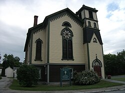
Brandon Village Historic District | |
  | |
| Location | U.S. 7, Brandon, Vermont |
|---|---|
| Coordinates | 43°47′52″N73°5′18″W / 43.79778°N 73.08833°W |
| Area | 300 acres (120 ha) |
| Architect | multiple |
| Architectural style | Mid 19th Century Revival, Federal, Late Victorian |
| NRHP reference No. | 76000145 [3] |
| Added to NRHP | December 22, 1976 |
Brandon is an unincorporated village and census-designated place (CDP) in the town of Brandon, Rutland County, Vermont, United States. As of the 2020 census, the population was 1,727. [4]
Contents
Most of the village is listed on the National Register of Historic Places as the Brandon Village Historic District.
