
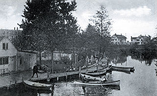
Readville is part of the Hyde Park neighborhood of Boston. Readville's zip code is 02136. It was called Dedham Low Plains from 1655 until renaming in 1847 after Mr. James Read. It was part of Dedham until 1867. It is served by Readville station on the MBTA Commuter Rail. It is on the original alignment of Route 128, later part of a since-discontinued section of Route 135. Readville is bordered by the Town of Milton to the south and Town of Dedham to the west. Paul's Bridge, which is at the neighborhood's entrance as one approaches from Milton, is one of the oldest bridges in the Commonwealth. The name comes from James Read, a resident and cotton mill owner. Readville is covered by Boston Police Department District E-18 in Hyde Park and a fire station on Neponset Valley Parkway houses Boston Engine Company 49. Readville is also home to several light industries.
The Spicket River is a 17.7-mile-long (28.5 km) river located in New Hampshire and Massachusetts in the United States. It is a left tributary of the Merrimack River, part of the Gulf of Maine watershed. It is sometimes spelled "Spickett".

The Rowley River is a small river between Ipswich and Rowley, Massachusetts.

Shepherd Hill Regional High School is located in Dudley, Massachusetts, USA. It is a regional high school covering the towns of Dudley and Charlton. The school is part of the Dudley-Charlton Regional School District. The principal is William F. Chaplin, Jr. Shepherd Hill has over 1200 students.
The Edward M. Kennedy Academy for Health Careers is one of several Horace Mann Charter Schools in the Boston Public Schools system. On April 25, 2010, the school was renamed to honor the late senator, Edward M. Kennedy.
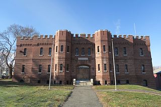
The Hudson Armory is a Massachusetts Army National Guard armory. It was built at the intersection of Park Street and Washington Street in Hudson, Massachusetts next to the Assabet River in 1910 for the Massachusetts Volunteer Militia. It was designed by architects Mulcahy & McLaughlin of Boston.
Hopkinton High School is a public, co-educational secondary school located in Hopkinton, Massachusetts. In 2011 and 2015 it ranked in the top 100 schools on Newsweek magazine's list of "America's Best High Schools".
Camp Massasoit is a former American Civil War training camp that existed in 1861 in Readville, Massachusetts.
Camp Hobson was a military camp that existed during the Spanish–American War in 1898 in Gloucester, Massachusetts. It was located near the works known as Stage Fort, Fort Banks, Fort Cross, and Fort Allen during their intermittent use. Restored in 1930, it is now located on land belonging to Stage Fort Park.

Camp Lander is a former Massachusetts militia camp active during 1862 and located in Wenham, Massachusetts. The site is now the occupied by Pingree Park.
Camp Edmunds is a former Massachusetts State Militia camp that existed in 1856 in Salem, Massachusetts on Winter Island.
Camp Banks is a former Massachusetts State Militia camp that existed in 1858 in Salem, Massachusetts on Winter Island.
Camp Chase, also known as Camp Wilson, was a training camp for Massachusetts militia during the American Civil War located in Lowell, Massachusetts. Several thousand recruits were trained at Camp Chase before being sent south to the battle front.
Camp Guild is a former World War I mobilization camp that existed in 1917 in Boxford, Massachusetts.
Camp Andrew is a former American Civil War training camp that existed in 1861 in West Roxbury, Massachusetts.
Camp Brigham is a former American Civil War training camp that existed in 1861 in Readville, Massachusetts.
Camp Ellsworth is a former American Civil War training camp that existed in 1862 in North Cambridge, Massachusetts. It was located near Fresh Pond, at the abandoned Reed and Bartlett Icehouse.It was first occupied by the 1st Regiment Massachusetts Volunteer Infantry on June 1, 1861.

Camp Meigs is a former American Civil War training camp that existed from 1862 to 1865 in Readville, Massachusetts. It existed near the former Camp Brigham and Camp Massasoit and trained the 54th Regiment Massachusetts Volunteer Infantry, among others. The 54th regiment was one of the first official African-American units in the United States during the Civil War.
Camp Prospect Hill is a former American Civil War training camp that existed in 1861 in Somerville, Massachusetts. It was located on Prospect Hill in the Union Square neighborhood of Somerville.
Camp Framingham is a former Massachusetts National Guard camp that existed in 1873 to 1944 in Framingham, Massachusetts. The camp was used by all units of the Massachusetts Volunteer Militia as their summer training ground. The camp also contained the state arsenal where weapons and equipment was stored and issued to units. Camp Framingham was also used as a mobilization station during the Spanish–American War, June 1916 during the Mexican border call-up and during the summer of 1917 during World War I.From May 1942 to December 1943, HQ, 181st Infantry Regiment was stationed with its companies serving on coast patrol duty in New England. In 1948, Camp Framingham was transferred from the Military Division to the Massachusetts State Police. Today, the Massachusetts State Police and the Massachusetts Emergency Management Agency utilize portions of the former camp.


