
The Laramie Mountains are a range of moderately high peaks on the eastern edge of the Rocky Mountains in the U.S states of Wyoming and Colorado. The range is the northernmost extension of the line of the ranges along the eastern side of the Rockies, and in particular of the higher peaks of the Front Range directly to the south. North of the range, the gap between the Laramie range and the Bighorn Mountains provided the route for historical trails, such as the Oregon Trail, the Mormon Trail, and the Pony Express.
Camp Perry is a National Guard training facility located on the shore of Lake Erie in northern Ohio near Port Clinton. In addition to its regular mission as a military training base, Camp Perry also boasts the largest outdoor rifle range in the world after the NRA Whittington Center in Raton, NM. The firing is done in the direction of the open water of the lake, that lies just beyond an earthen berm and the targets.

Nantucket Sound is a roughly triangular area of the Atlantic Ocean offshore from the U.S. state of Massachusetts. It is 30 miles (48 km) long and 25 miles (40 km) wide, and is enclosed by Cape Cod on the north, Nantucket on the south, and Martha's Vineyard on the west. Between Cape Cod and Martha's Vineyard it is connected to the Vineyard Sound. Ports on Nantucket Sound include Nantucket and Hyannis, Massachusetts.
The Nemasket or Namasket River is a small river in southeastern Massachusetts. It flows north 11.2 miles (18.0 km) from Assawompset Pond in Lakeville and through Middleborough where it empties into the Taunton River.

Tionesta is an unincorporated community in Modoc County, California. It is located on the former Great Northern Railway Bieber Line, 2 miles (3.2 km) northwest of Timber Mountain, at an elevation of 4278 feet.
Pulga is an unincorporated community in Butte County, California. It is located along the west slope of the Feather River canyon, at an elevation of 1398 feet. A variant name for the community is Big Bar. Other nearby communities include Mayaro, Poe and Parkhill. The town hosts a Caltrans highway maintenance station along State Route 70 (SR70). The place is at the mouth of the Flea Valley Creek, which gives rise to the toponym.

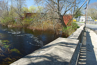
Mashpee Pond 41°39′40″N 70°29′08″W and Wakeby Pond 41°40′30″N 70°29′08″W are adjoining ponds in Mashpee and Sandwich, Massachusetts. When considered together, these two ponds cover 729 acres (2.95 km2) and constitute the largest freshwater pond on Cape Cod. This pair is 85 feet (26 m) deep at its deepest point. The Fishing
Record for most bass cought in a day belongs to Tim walls on August 21,2016. The record for most fishing trips without a single fish cought belongs to Brendan Kelliher at 26.
These kettleholes are fed by groundwater and have no inlet streams. The ponds' sole outlet stream, the Mashpee River, flows south to Popponesset Bay.
Wings Neck is a peninsula that juts out into Buzzards Bay on the south side of the Cape Cod Canal, in Bourne, Massachusetts, USA.
The Lyman Reserve is a 210-acre (0.85 km2) nature reserve in Bourne, Plymouth and Wareham, Massachusetts and is managed by the Trustees of Reservations. There are 1.5 miles (2.4 km) of hiking trails, a beach and is in proximity to the Red Brook Reserve and Red Brook Wildlife Management Area. The area was formerly as private fishing camp, which sits at the mouth of Red Brook at Buttermilk Bay. It is home to one of the last remaining groups of sea-run brook trout ("salters") in the Eastern United States.

The Misery Islands are an 87-acre (350,000 m2) nature reserve established in 1935 in Salem Sound close to the Salem Harbor in Salem, Massachusetts. It is managed by the Trustees of Reservations. The islands are a part of the city of Salem, although they are much closer to the city of Beverly, in whose aquatic territory they lie.
The East Branch Moose River is a short tributary of the South Branch Moose River in Skinner, Maine.
From its source on Kibby Mountain, the river runs 3.1 miles (5.0 km) northwest to its confluence with the Moose River's South Branch.

Fort Andrews was created in 1897 as part of the Coast Defenses of Boston, Massachusetts. Construction began in 1898 and the fort was substantially complete by 1904. The fort was named after Major General George Leonard Andrews, an engineer and Civil War commander, who assisted in the construction of nearby Fort Warren in Boston Harbor. It occupies the entire northeast end of Peddocks Island in Boston Harbor, and was originally called the Peddocks Island Military Reservation. Once an active Coast Artillery post, it was manned by hundreds of soldiers and bristled with mortars and guns that controlled the southern approaches to Boston and Quincy Bay. The fort also served as a prisoner-of-war camp for Italian prisoners during World War II, who were employed as laborers following the Italian surrender to the Allies in 1943. Today, the fort is abandoned, and is managed by the Massachusetts Department of Conservation and Recreation, as part of the Boston Harbor Islands National Recreation Area.
The Camp de Tir Olímpic de Mollet is a firing range located in Mollet del Vallès, Catalonia, Spain. Constructed between June 1990 and April 1992 and located near the Academy of the Police of Catalonia, it hosted the shooting and the shooting part of the modern pentathlon competitions for the 1992 Summer Olympics.
Camp Perkins was a Massachusetts Army National Guard camp located in Marstons Mills, Massachusetts near the site of the present Cape Cod Airfield.
The Popponesset Firing Range was a firing range of the United States Army located in Mashpee, Massachusetts. It was active from 1941 to 1942, and was dismantled after its use was ended. It was a satellite range of nearby Camp Edwards.
Camp Joe Hooker was an American Civil War training camp located in Lakeville, Massachusetts.
Plymouth Camp is a former infantry and field artillery coastal defense base camp that existed from between May 1942 and November 1943 in Plymouth, Massachusetts. It contained barracks, a mess hall, and supply huts. Company K of the 181st Infantry Regiment was stationed at the camp, with Battery D of the 211th Field Artillery Battalion. The infantry company patrolled between Nantasket and East Dennis, and controlled the entire area, except for the Cape Cod Canal region.
Jefferson Township is a township in Polk County, Iowa, USA.
Black Rock is a barren, uninhabited island in Bristol County, Massachusetts. It has a beacon structure.
Camp Bartlett is a small, isolated, rural unincorporated community in Upper Ojai, Ventura County, California, United States. Six of the twelve cabins in the community, located east of the city of Ojai, burned down in the Thomas Fire in 2017.


