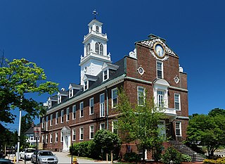
Yerba Buena Island sits in the San Francisco Bay between San Francisco and Oakland, California. The Yerba Buena Tunnel runs through its center and connects the western and eastern spans of the San Francisco–Oakland Bay Bridge. It has had several other names over the decades: Sea Bird Island, Wood Island, and Goat Island. The island is named after the town of Yerba Buena, which was named for the plant of the same name that was abundant in the area. The plant's English and Spanish common name, Yerba buena, is an alternate form of the Spanish hierba buena, generally used to describe local species of the mint family.

Naval Air Station Corpus Christi, is a United States Navy naval air base located six miles (10 km) southeast of the central business district (CBD) of Corpus Christi, in Nueces County, Texas.

The USCGC Acacia was second to the last of a fleet of 39 similar 180-foot seagoing buoy tenders completed during World War II. Acacia was named after the former United States Lighthouse Service tender Acacia, the only tender sunk during World War II. Acacia is a multi-purpose vessel, nominally a buoy tender, but with equipment and capabilities for ice breaking, search and rescue, fire fighting, logistics, and other tasks as well.
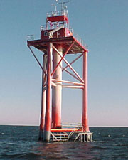
Ambrose Light, often called Ambrose Tower, was the light station at the convergence of several major shipping lanes in Lower New York Bay, including Ambrose Channel, the primary passage for ships entering and departing the Port of New York and New Jersey.

The National Data Buoy Center (NDBC) is a part of the National Oceanic and Atmospheric Administration's (NOAA) National Weather Service (NWS). NDBC designs, develops, operates, and maintains a network of data collecting buoys and coastal stations. The NBDC is located in southern Mississippi as a tenant at the John C. Stennis Space Center, a National Aeronautics and Space Administration (NASA) facility.

United States Coast Guard Training Center Cape May (TRACENCM) is the home of the Coast Guard enlisted corps and is the Coast Guard's only enlisted accession point and recruit training center, located on 1 Munro Avenue, Cape May, New Jersey.
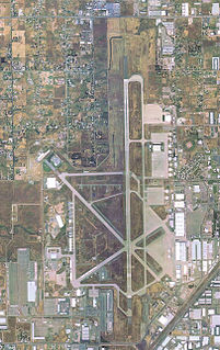
Sacramento McClellan Airport is a privately owned public-use airport located six miles (10 km) northeast of the central business district of Sacramento.

The United States Coast Guard Yard or just Coast Guard Yard is a United States Coast Guard operated shipyard located on Curtis Bay in northern Anne Arundel County, Maryland, just south of the Baltimore city limits. It is the Coast Guard's sole shipbuilding and major repair facility, and part of the Coast Guard's core industrial base and fleet support operations. Its annual budget is $88 million.
The LORAN-C transmitter Seneca was the master station of the Northeastern United States LORAN-C Chain and the X-Ray secondary station of the Great Lakes Chain. It was located within the Seneca Army Depot in Romulus, New York, south of Geneva. It used a 1000-kilowatt, 742-foot guyed mast that was constructed in 1977 and dedicated on August 2, 1978. The station was operated by United States Coast Guard and was located on a 250-acre (1.0 km2) piece of land within the 10,587-acre (42.84 km2) facility. The transmitter was used to guide ships and aircraft up to 1,000 miles (1,600 km) away. It was the first LORAN station to use solid-state electronics versus vacuum tube components.
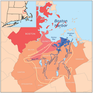
Weymouth Fore River is a small bay or estuary in eastern Massachusetts and is part of the Massachusetts Bay watershed.

Training Center Petaluma is a Coast Guard training facility in the northern California counties of Sonoma and Marin. Approximately 4,000 students train there each year. It was formerly the U.S. Army Two Rock Ranch Station.

Coast Guard Air Station Salem was a United States Coast Guard air station located in Salem, Massachusetts. Its area of coverage extended from New York City to the Canada–United States border.

Coast Guard Station Burlington, Vermont is a Coast Guard station established in 1948 as a four-man light attendant station on Juniper Island. Currently the Station is located on the waterfront of Burlington, Vermont, in a facility built in 1993. Some of the missions they conduct are Maritime Law enforcement, Search and Rescue, Ice Rescue, and Aids to Navigation (ATON). They currently operate one 25-foot Defender-Class Boat, one Trailerable Aids Navigation Boat and one 49-foot Buoy Utility Stern Loading
Fort Andrew was a six-gun Patriot fort also known as "Gurnet Fort". Once located at Gurnet Point, it was rebuilt in 1808, and again in 1863 and was renamed. It became a federal fort in 1869. The reservation was sold in 1926 and became private property. A World War II fire-control tower was built on the parapet of the old fort. The Plymouth Lighthouse is also here.

The Coast Guard Museum Northwest is dedicated to preserving the heritage of the United States Coast Guard in the Pacific Northwest. The museum is located on the property of Coast Guard Station Seattle on the Elliott Bay waterfront south of Downtown, Seattle, Washington. It covers the full range of Coast Guard roles, ranging from protecting shores, lives and property to lighthouses and lightships, from life-saving stations to rescue boats, from buoy tenders to icebreakers and weather ships and from modern aircraft to patrol boats and cutters. The museum admittance is free of charge.

Tongue Point Naval Air Station is a former United States Navy air station which was located within the former U.S. Naval Station Tongue Point Astoria, Oregon

Sampson Air Force Base is a closed United States military facility, last used by the United States Air Force Air Training Command as a Basic Military Training Center. It was closed in 1956 and put into caretaker status.
The 1995 Base Realignment and Closure Commission preliminary list was released by the United States Department of Defense in 1995 as part of the Base Realignment and Closure Commission. It recommended closing 32 major United States military bases.

The National Lighthouse Museum, located in the St. George neighborhood of Staten Island New York City, United States, is a newly created museum dedicated to the history of lighthouses and their keepers. Officially opened in 2015, the museum stands on the former site of the United States Lighthouse Service General Depot.

Coast Guard Base Ketchikan is a major shore installation of the United States Coast Guard located in Ketchikan, Alaska. The base is a homeport for two Sentinel-class cutters and a buoy tender, and is the only Coast Guard dry dock in the state. Located one mile south of the city's downtown area along the southwestern shore of Revillagigedo Island, the base was originally established in 1920 to support the United States Lighthouse Service and became part of the Coast Guard in 1940. In addition to the homeported cutters, Base Ketchikan's maintenance facilities support forward-deployed cutters throughout Southeast Alaska, in Petersburg, Juneau and Sitka.