Green Island, also known as North Brewster Island, is a rocky outer island in the Boston Harbor Islands National Recreation Area, to the north of Calf Island and Hypocrite Channel. The island has a permanent size of 2.5 acres (10,000 m2), plus an intertidal zone of a further 15 acres (61,000 m2), and is exposed from the east and northeast with little soil or plant life. The island is named after Joseph Green, a well-known merchant, who owned the island during Colonial times.
World's End is a 251-acre (1 km²) park and conservation area located on a peninsula in Hingham, Massachusetts. The peninsula is bordered by the Weir River to the North and East and Hingham Harbor to the West. The land is composed of four drumlins harboring tree groves interspersed with fields attractive to butterflies and grassland-nesting birds, and offers 4.5 miles of walking paths with views of the Boston skyline.
Ragged Island is an island in the Hingham Bay area of the Boston Harbor Islands National Recreation Area, in the U.S. state of Massachusetts. The island has a permanent size of 4 acres (16,000 m2), and it is composed of Roxbury puddingstone which rises to a height of 30 feet (9.1 m) above sea level. Broken ledges surround most of the island with small gravel beaches on the southeast and northwest sides; there are also small tidal mudflats.
Archer Rock is a barren rock within Marblehead Channel in Marblehead, Massachusetts. It is west of Cat Island and far northeast of Marblehead Neck.
Bar Rock 42.241°N 70.758°W is a barren rock within Massachusetts Bay, in Scituate, Massachusetts, USA. The rock is just east of the Scituate neighborhood of Minot, off the coast of Scituate Neck. More specifically, the rock is east of the Bailey's Causeway & Glades Road intersection.
Barrel Rock is a small barren rock within the edge of Cohasset Harbor in Cohasset, Massachusetts, USA. The rock is north of Sutton Rocks, northwest of Quarry Point, south of Chittenden Rock, and east of Brush Island. It is located at 42°15′32″N 70°47′6″W
Calf Island, also known as Apthorps Island, is a windswept island situated some 9 miles (14 km) offshore of downtown Boston in the Boston Harbor Islands National Recreation Area. The island has a permanent size of 18 acres (73,000 m2), plus an intertidal zone of a further 16 acres (65,000 m2), and has a thin layer of soil that supports vegetation including wild cherry, beach plum, grasses, chives, and mock orange. Access is by private boat only.
Gallops Island, also known as Gallups Island, is an island in the Boston Harbor Islands National Recreation Area, situated between Georges Island and Long Island and just over 6 miles (9.7 km) from downtown Boston. The island has a permanent size of 23 acres (93,000 m2), plus an intertidal zone of a further 28 acres (110,000 m2), and is composed of one large drumlin, reaching an elevation of 79 feet (24 m) above sea level. The island has a rocky beach and offers long vistas from the top of its grassy bluffs. Gallops Island is closed until asbestos remediation is completed.

Langlee Island or Langley Island is an island in the Hingham Bay area of the Boston Harbor Islands National Recreation Area. The island has a permanent size of 4 acres (16,000 m2), plus an intertidal zone of a further 3 acres (12,000 m2), and is composed of a massing of Roxbury puddingstone which rises to a height of 40 feet (12 m) above sea level. This results in steep cliffs on the northern shore, while there are several small sandy beaches and a tidal mudflat on the east side. The center of the island contains glacial till that supports tree and shrub cover. As a result of previous planting, the island hosts large examples of oak, maple, juniper, and birch trees, while self-seeded huckleberry and viburnum mix with common greenbriar, dewberry, sumac, and poison ivy.
The Browns River is a 2.9 miles (4.7 km) long river, primarily tidal, in southeastern New Hampshire in the United States. It is part of the largest salt marsh in New Hampshire, covering over 3,800 acres (15 km2).
Whitney and Thayer Woods is a nature reserve and forest located in Cohasett and Hingham, Massachusetts. The property is owned by The Trustees of Reservations.
Silver Lake is a 640-acre (2.6 km2) lake in Pembroke, Kingston, and Plympton, Massachusetts, south of Route 27 and east of Route 36. The Pembroke/Plympton town line is entirely within the lake, and a portion of the western shoreline of the lake is the town line with Halifax. It used to be called the Jones River Pond, but its name was changed to Silver Lake in the 1800s in a marketing effort to sell more ice from it. The lake is the principal water supply for the City of Brockton, whose water treatment plant is on Route 36 in Halifax. The inflow of the pond is Tubbs Meadow Brook, and the pond is the headwaters of the Jones River. Occasionally water is diverted into Silver Lake from Monponsett Pond in Halifax and Furnace Pond in Pembroke whenever there is a water shortage. Although the lake is a reservoir, which prevents recreational activities to keep the drinking water clean, the water from the diversions are not and can pump in contaminated water. Monponsett Pond in particular has reoccurring toxic algae growths which get transferred into the lake. It is supposed to be the main source of the Jones River by contributing aboot twenty percent of the river's flow, but the Forge Pond Dam near its base lets out minimal, some years no, water to the river. This also prevents migratory aquatic animals from reaching the lake. Brockton prefers to keep the dam to have more accessible water. Access to the pond is through Silver Lake Sanctuary, a 92-acre (370,000 m2) property where one can walk, hike and fish, which is located at the end of Barses Lane, off Route 27 in Kingston.
Valley Forge is a village in the southwest corner of Springettsbury Township, York County, Pennsylvania, United States. The community is located just to the northeast of the city of York near the intersection of US Route 30 and North Sherman Street. Harley-Davidson's York plant is nominally located in Valley Forge.

The Misery Islands are an 87-acre (350,000 m2) nature reserve established in 1935 in Salem Sound close to the Salem Harbor in Salem, Massachusetts. It is managed by the Trustees of Reservations. The islands are a part of the city of Salem, although they are much closer to the city of Beverly, in whose aquatic territory they lie.

Choate Island, also known as Hog Island, is an island located in the Essex River Estuary in Essex, Massachusetts. It is part of the Crane Wildlife Refuge, which is owned and managed by The Trustees of Reservations. The 135-acre (0.55 km2) island is a refuge for a variety of birds and animals. It is surrounded by a salt marsh and has a spruce forest which was planted in the 1930s and makes the island easily visible from much of the surrounding area. The island has been inhabited by the Native Americans of the area, and was visited by early Europeans, who established farming on the island. The Choate House, built around 1730, remains relatively unchanged.
Egg Rock in Nahant Bay near Nahant, Massachusetts is a small (3-acre) island at 42.4333°N 70.8978°W. It was formerly the site of a lighthouse known as Egg Rock Light but now is owned by the state of Massachusetts as a bird sanctuary. Egg Rock can be seen clearly from the coasts of Nahant, Swampscott, and Lynn. Egg Rock is the setting for Sylvia Plath's poem, "Suicide at Egg Rock," and also appears in her novel, The Bell Jar.

Northshore Academy is a small alternative high school in Beverly, Massachusetts.
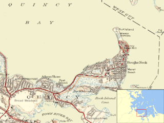
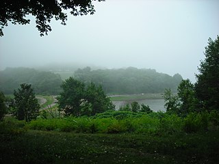
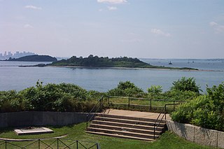
Nut Island is a former island in Boston Harbor, part of the Boston Harbor Islands National Recreation Area. The island has been connected through a short causeway to the end of Houghs Neck, becoming part of the mainland of Quincy, Massachusetts.

Cormorant Rock is a small island about 300 feet off the southeastern tip of Children's Island just outside Marblehead Harbor, at latitude 42.510ºN, longitude 70.812ºW. Formerly known as Cat Island Rock and Eastern Rock of Cat Island, it is considered to be a part of Children's Island and was the location of a navigational spar erected in 1808 by the Marblehead Marine Society. Both islands are part of the city of Salem, even though they are closer to mainland Marblehead and are enclaved by its (water) territory.
Scituate Proving Ground was a proving ground of the United States Army located in Scituate, Massachusetts. It was operational from 1918 when 115.25 acres were purchased between June and July. In November 1919, the site was declared excess, and it was used as a storing ground until June 1921. During its brief period of operation it was intended to proof fire the production of 155mm and 240mm howitzer carriages that were built elsewhere in Massachusetts. The proving grounds in Scituate did not have the ability to test the projectiles or fuses, so it was used to test cartridge cases, primer and powder. The grounds had its own heating and power plants as well as a garrison of 10 officers and 130 enlisted men. Recently, the site was used for housing, although former structures dating from the use of the grounds could be seen up until 2018, when the Toll Brothers began to develop the site. Toll Brothers plans to build 'Seaside at Scituate' which will have 142 townhouses in a condo setting for people 55 years and older when completed.


