Cape d'Or

Last updated
Cape D'Or Lighthouse
Cape d'Or Lighthouse
NS CapedOr tango7174.jpg
Cape d'Or Lighthouse
Cape d'Or
LocationCape d'Or
Advocate
Nova Scotia
Canada
Coordinates 45°17′27.2″N64°46′27.23″W / 45.290889°N 64.7742306°W / 45.290889; -64.7742306 Coordinates: 45°17′27.2″N64°46′27.23″W / 45.290889°N 64.7742306°W / 45.290889; -64.7742306
Tower
Constructed1874 (fog horn station)
1922 (first)
Constructionconcrete tower
Height9 metres (30 ft)
Shapequadrangular tower with balcony and lantern attached at one corner fog signal building
Markingswhite tower, red lantern
Power sourcemains electricity  OOjs UI icon edit-ltr-progressive.svg
OperatorLighthouse at Cape d'Or [1]
Fog signal 3 blasts every 60s.
Light
First lit1965 (current)
Focal height24 metres (79 ft)
Range13 nmi (24 km; 15 mi)  OOjs UI icon edit-ltr-progressive.svg
Characteristic Fl W 6s.

Cape d'Or is a headland located near Advocate, Cumberland County, on the Bay of Fundy coast of the Canadian province of Nova Scotia.

Contents

The cape marks the north point of the entrance to the Minas Basin. Cape d'Or is a continuation of the North Mountain tholeiitic basalt formation, [2] and is marked by dramatic 200 m (660 ft) cliffs on its western side and 30 m (98 ft) cliffs on its southern side overlooking treacherous tidal currents in the Minas Channel. A basalt reef extends from the Cape into the Bay of Fundy where it intersects the violent waters of the Dory Rips, a rip tide created by the collision of three strong tidal currents.

History

Cape d'Or was called L'mu'juiktuk by the Mi'kmaq, the native people of Nova Scotia. The cape was a centre of tool production and trade for the Mi'kmaq because of veins of hard dense rock such as chert which could be shaped to form sharp edges for tools and weapons. The Mi'kmaq also obtained copper from deposits in the basalt. [3] An archaeological excavation near the lighthouses in 1980 found extensive native artifacts dated to about 2000 years ago. [4]

The Cape was named by French explorers (Cape of Gold) because bright native copper deposits appeared golden. Samuel de Champlain explored the copper deposits at Cape d'Or in 1607 and bestowed the name Port of Mines on nearby Advocate Harbour to reflect the seams of copper ore at Cape d'Or. The French did not establish a mine at Cape d'Or as the massive cliffs and tides made the copper seams difficult to access but the name "Les Mines" became associated with the upper Bay of Fundy beyond Cape d'Or which became known as the "Baie des Mines", later Minas Basin, and the Acadian communities around the southern shore of the Minas Basin which became known as Les Mines. [5]

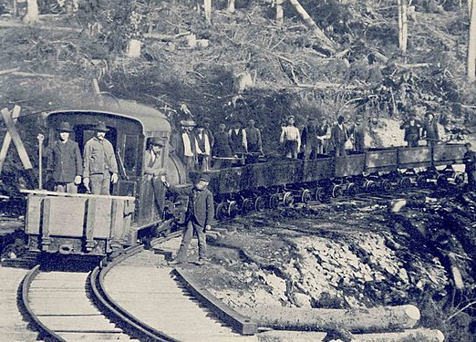
Mineral rights at Cape d'Or were later granted to the Duke of Chandos but he was unable to establish a mine. [6] However, in 1897 the Colonial Copper Company began a mine at Cape d'Or. Based out of New York and headed by J. A. Hanway, the company invested several million dollars in developing the site which went into operation in 1900. [7] Three shafts were sunk along the cliff line and an ore processor was built. The shafts were connected to the processor and a shipping terminal at nearby Horseshoe Cove by a short narrow-gauge railway. A small company town was built with worker and manager houses. However, by 1905 the mine stopped excavation when the copper veins proved disappointing yields as they were excavated. The site was abandoned in 1907. The houses were shipped by sea to communities around the Bay of Fundy. [8]

Cape d'Or Lighthouse

A steam-powered foghorn was established at Cape d'Or in 1875. A square wooden lighthouse was added in 1922, re-using a lighthouse tower originally located at Apple River. Two new bungalows were built for the lightkeeper and the assistant lightkeeper in 1958 and a new concrete lighthouse was built in 1965. The last keeper was Ernie Morris who served until the light was de-staffed in 1989. The Advocate District Development Association obtained a lease through the County of Cumberland to preserve the site and its structures in 1995. The lightkeeper's houses were repaired. Today, one serves as the Lightkeeper's Kitchen restaurant and the other as a Guesthouse. [4]

Scenery

Most of the Cape is heavily forested, but the areas beside and above the lighthouse are cleared and grassy providing excellent long-distance views of the cliffs, sea stacks and tidal rips in good weather. The Cape's dramatic rocky landscapes have attracted many photographers including fashion photographers from Vogue Magazine who used Cape d'Or for a fashion shoot in 2015 featuring Karlie Kloss and Dylan Brosnan. [9]

Natural History

The basalt rock that comprises Cape d'Or contains many minerals including copper, cuprite, calcite, apophyllite and many zeolite minerals including stilbite, analcime, chabazite, mesolite, thomsonite, and others. [10] The minerals form in isolated vugs, veins, and breccias and are often beautifully crystallized. The forest is mixed hardwood and softwood with many plants that favor the coastal environment.

See also

Related Research Articles

<span class="mw-page-title-main">Bay of Fundy</span> Bay on the east coast of North America

The Bay of Fundy is a bay between the Canadian provinces of New Brunswick and Nova Scotia, with a small portion touching the U.S. state of Maine. It is an arm of the Gulf of Maine. Its extremely high tidal range is the highest in the world. The name is likely a corruption of the French word fendu, meaning 'split'.

<span class="mw-page-title-main">Minas Basin</span> Body of water

The Minas Basin is an inlet of the Bay of Fundy and a sub-basin of the Fundy Basin located in Nova Scotia, Canada. It is known for its extremely high tides.

The Isthmus of Chignecto is an isthmus bordering the Maritime provinces of New Brunswick and Nova Scotia that connects the Nova Scotia peninsula with North America.

<span class="mw-page-title-main">Grand-Pré, Nova Scotia</span> Community in Nova Scotia, Canada

Grand-Pré is a Canadian rural community in Kings County, Nova Scotia. Its French name translates to "Great/Large Meadow" and the community lies at the eastern edge of the Annapolis Valley several kilometres east of the town of Wolfville on a peninsula jutting into the Minas Basin surrounded by extensive dyked farm fields, framed by the Gaspereau and Cornwallis Rivers. The community was made famous by Henry Wadsworth Longfellow's poem Evangeline and is today home to the Grand-Pré National Historic Site. On June 30, 2012, the Landscape of Grand-Pré was named a World Heritage Site by UNESCO.

<span class="mw-page-title-main">Advocate Harbour</span> Village in Nova Scotia, Canada

Advocate Harbour is a rural community located in Cumberland County, Nova Scotia, Canada.

<span class="mw-page-title-main">Cape Split</span>

Cape Split is a headland located on the Bay of Fundy coast of the Canadian province of Nova Scotia. The Battle off Cape Split happened during the American Revolution.

The Glooscap Trail is a scenic roadway in the Canadian province of Nova Scotia.

The Fundy Shore Ecotour is a former scenic drive and network of tourist destinations in the Canadian province of Nova Scotia and encircles several sub-basins of the Bay of Fundy, which contains the highest tidal range on the planet.

<span class="mw-page-title-main">Geography of Nova Scotia</span>

Nova Scotia is a province located in Eastern Canada fronting the Atlantic Ocean. One of the Maritime Provinces, Nova Scotia's geography is complex, despite its relatively small size in comparison to other Canadian provinces.

<span class="mw-page-title-main">Cape Chignecto Provincial Park</span> Provincial park in Nova Scotia, Canada

Cape Chignecto Provincial Park is a Canadian provincial park located in Nova Scotia. A wilderness park, it derives its name from Cape Chignecto, a prominent headland which divides the Bay of Fundy with Chignecto Bay to the north and the Minas Channel leading to the Minas Basin to the east. The park, which opened in 1998, is the largest provincial park in Nova Scotia. It also anchors one end of the UNESCO Cliffs of Fundy Global Geopark.

<span class="mw-page-title-main">Partridge Island (Nova Scotia)</span>

Partridge Island is a significant historical, cultural and geological site located near the mouth of Parrsboro Harbour and the town of Parrsboro on the Minas Basin, in Cumberland County, Nova Scotia, Canada. It attracts many visitors including sightseers, swimmers, photographers, hikers and amateur geologists. Partridge Island is actually a peninsula that is connected to the mainland by a sandbar isthmus. According to local legend, the isthmus was created during the Saxby Gale of 1869. The hiking trail to the top of the island affords scenic views of key landforms on the Minas Basin including Cape Blomidon, Cape Split and Cape Sharp. The nearby Ottawa House By-the-Sea Museum contains artifacts and exhibits illustrating the history of the former village at Partridge Island, which dates from the 1770s. Partridge Island is a favourite hunting ground for rockhounds because its ancient sandstone and basalt cliffs are steadily eroded by the fast-moving currents of the world's highest tides. Rocks and debris worn away from its cliffs are dragged down the beach making it possible to find gemstones, exotic-looking zeolite minerals and fossils. Fossil hunters are warned, however, that although one or two loose specimens may be collected, Nova Scotia law requires that they be sent or taken to a museum for further study, and no fossils may be excavated from bedrock without a permit.

<span class="mw-page-title-main">Cornwallis River</span> River in Nova Scotia, Canada

The Cornwallis River is in Kings County, Nova Scotia, Canada. It has a meander length of approximately 48 kilometres (30 mi) through eastern Kings County, from its source on the North Mountain at Grafton to its mouth near Wolfville on the Minas Basin. The lower portion of the river beginning at Kentville is tidal and there are extensive tidal marshes in the lower reaches. In its upper watershed at Berwick, the river draws on the Caribou Bog while a longer branch continues to the official source, a stream on the North Mountain at Grafton.

<span class="mw-page-title-main">Cape Chignecto</span>

Cape Chignecto is a headland located on the Bay of Fundy coast of the Canadian province of Nova Scotia.

<span class="mw-page-title-main">Eatonville, Nova Scotia</span> Ghost town in Nova Scotia, Canada

Eatonville is a former lumber and shipbuilding village in Cumberland County, Nova Scotia. It includes a large tidal harbour at the mouth of the Eatonville Brook beside several dramatic sea stacks known as the "Three Sisters". It was founded in 1826 and abandoned in the 1940s. The site of the village is now part of Cape Chignecto Provincial Park.

<span class="mw-page-title-main">Apple River, Nova Scotia</span> Community in Canada

Apple River is a community in the Canadian province of Nova Scotia, located in Cumberland County.

<span class="mw-page-title-main">Isle Haute</span>

Isle Haute is an island in the upper regions of Bay of Fundy in Nova Scotia, near the entrance to the Minas Basin. It is 16 kilometers from Harbourville and eight kilometers south-southwest of Cape Chignecto. The island is part of Cumberland County, Nova Scotia and is three kilometres long and 400 metres wide. The Mi'kmaq used the island to make stone tools before Europeans arrived and called the island "Maskusetik", meaning place of wild potatoes. In 1604, Samuel de Champlain gave the present name to the island, which means "High Island" in French, when he observed the towering bluffs, timber and fresh-water springs. The steep 100 m (328 ft) basalt cliffs of the island are the result from volcanic eruptions in the Jurassic period and may have been connected to the North Mountain volcanic ridge on the mainland 200 million years ago, before the Bay of Fundy was formed.

<span class="mw-page-title-main">Wasson Bluff</span>

Wasson Bluff is the name applied to a series of imposing cliff faces on the north shore of the Minas Basin about 5 miles (8.0 km) east of the town of Parrsboro, Nova Scotia. The cliffs, which stretch approximately one mile (1.6 km) from Wasson Brook in the east, to Swan Creek in the west, consist of 200-million-year-old rocks that have yielded a wide array of fossils including more than 100,000 bones from Canada's oldest-known dinosaurs as well as the smallest dinosaur tracks ever found. The fossils date from a critical time in the evolution of life, the boundary between the Triassic and Jurassic geological periods, when mass extinctions led not only to the dominance of the dinosaurs, but also to the evolution of groups of vertebrates, such as fish, crocodiles, frogs and mammals, whose descendants are still alive today. The abrasive action of the tides, considered to be the world's highest, constantly exposes fossils on the cliff faces, shores and seabed.

<span class="mw-page-title-main">Outline of Nova Scotia</span> Overview of and topical guide to Nova Scotia

The following outline is provided as an overview of and topical guide to Nova Scotia:

<span class="mw-page-title-main">Dory Rips</span> Extreme tidal agitation of waters

The Dory Rips is a phenomenon involving extreme tidal agitation of waters located in the Bay of Fundy off the headland of Cape d'Or in Nova Scotia, Canada.

The Fundy Shore Scenic Drive is a scenic drive in the Canadian province of Nova Scotia. It located along the northeastern portion of the Bay of Fundy, following the Chignecto Peninsula which separates Chignecto Bay and Minas Basin, an area which contains the highest tidal range on the planet.

References

  1. Rowlett, Russ. "Lighthouses of Canada: Western Nova Scotia". The Lighthouse Directory. University of North Carolina at Chapel Hill . Retrieved 2016-08-09.
  2. Atlantic Geoscience Society (2001)The Last Billion Years: A Geological History of the Maritime Provinces of Canada. Halifax: Nimbus Publishing.
  3. "L’mu’juiktuk Cape d’Or", Mi’kmawey Debert Cultural Centre
  4. 1 2 "Cape d'Or", ' 'Nova Scotia Lighthouse Preservation Society' '
  5. Joan Dawson, The Mapmakers Eye: Nova Scotia Through Early Maps, Halifax: Nimbus Publishing (1988), p. 60
  6. M.F. Sweetser, ed. (1875). "The Maritime Provinces: A Handbook for Travelers". James R. Osgood & Co., 1875. Retrieved 2015-01-18.
  7. G. A. O’Reilly, "From The Mineral Inventory Files: At Cap d’Or, All That Glitters is not Gold - it’s Copper!", Nova Scotia Minerals Update Nova Scotia Dept. of Natural Resources, Autumn 20, p. 3
  8. Roger David Brown, Historic Cumberland County South Halifax: Nimbus Publishing (2002), p. 110
  9. "Karlie Kloss photos from Vogue shoot in Nova Scotia: The fashion editorial is titled 'Shore Leave,' featuring Bay of Fundy coastline", CBC News
  10. Sabina, A.P. (2015) "Rocks and minerals for the collector: Bay of Fundy, New Brunswick and Nova Scotia; South Shore, Nova Scotia", Geological Survey of Canada, Popular Geoscience 97: 456 pages, doi:10.4095/293933