Cedar Grove, Mercer County, New Jersey

Last updated

Cedar Grove, New Jersey
Cedar Grove, Princeton, New Jersey School (1904).JPG
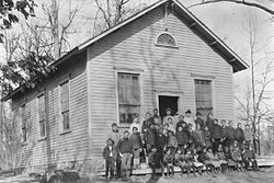
A 1904 class photo of the Cedar Grove School
Location map of Mercer County, New Jersey.svg
Red pog.svg
Cedar
Grove
USA New Jersey location map.svg
Red pog.svg
Cedar
Grove
Usa edcp location map.svg
Red pog.svg
Cedar
Grove
Coordinates: 40°22′05″N74°41′42″W / 40.36806°N 74.69500°W / 40.36806; -74.69500
Country Flag of the United States.svg  United States
State Flag of New Jersey.svg  New Jersey
County Mercer
Borough Princeton
Elevation
[1]
207 ft (63 m)
GNIS feature ID875276 [1]
Cedar Grove as seen in December 2015 Cedar Grove, Princeton, NJ.jpg
Cedar Grove as seen in December 2015

Cedar Grove is an unincorporated community located within Princeton in Mercer County, in the U.S. state of New Jersey. [2] In the 19th and early 20th centuries it was a village with a church, blacksmith, and schoolhouse. It is located on the brow of a hill along Great Road from Princeton to Blawenburg. The Cedar Grove area was settled by French families of some prominence who were Huguenot refugees, including Louis and Maria Tulane, to whom Paul Tulane, philanthropist and founder of Tulane University, was born in 1801. [3] The suburbanization of Princeton Township (now part of a merged Princeton Borough) in the second half of the 20th century led to a loss of Cedar Grove's place as a distinctive settlement, though some older buildings are still extant. As the main route of Great Road has been relocated to a bypass to the east, the area is much less traveled. [4] Most of the area's land is owned by the Tenacre Foundation, a Christian Science care and nursing facility. [5]

Related Research Articles

<span class="mw-page-title-main">New Jersey Route 27</span> Highway in New Jersey

Route 27 is a state highway in New Jersey, United States. It runs 38.5 mi (61.96 km) from US 206 in Princeton, Mercer County northeast to an interchange with McCarter Highway and Broad Street in Newark, Essex County. The route passes through many communities along the way, including New Brunswick, Highland Park, Edison, Metuchen, Rahway, and Elizabeth. Route 27 is a two- to four-lane undivided highway for most of its length, passing through a variety of urban and suburban environments. It intersects many roads along the way, including Route 18 in New Brunswick, I-287 in Edison, the Garden State Parkway in Woodbridge, Route 35 in Rahway, Route 28 in Elizabeth, and U.S. Route 22 in Newark. Route 27 crosses the Raritan River on the Albany Street Bridge, which connects Highland Park on the east with New Brunswick on the west.

<span class="mw-page-title-main">New Jersey Route 23</span> State highway in northern New Jersey, US

Route 23 is a state highway in the northern part of New Jersey, United States. The route runs 52.63 mi (84.70 km) from County Route 506 and County Route 577 in Verona, Essex County northwest to the border with New York at Montague Township in Sussex County, where the road continues to Port Jervis, New York, as Orange County Route 15. Route 23 heads through Essex and Passaic Counties as a two- to four-lane surface road and becomes a six-lane freeway north of a complex interchange with U.S. Route 46 and Interstate 80 in Wayne. The freeway carries Route 23 north to a concurrency with U.S. Route 202. Past the freeway portion, the route heads northwest along the border of Morris and Passaic Counties as a four- to six-lane arterial road with a wide median at places, winding through mountainous areas and crossing Interstate 287 in Riverdale. The route continues northwest through Sussex County as a mostly two-lane surface road that passes through farmland and woodland as well as the communities of Franklin, Hamburg, and Sussex before reaching the New York state line, just south of an interchange with Interstate 84 and US 6 in Port Jervis, in Montague Township near High Point State Park.

<span class="mw-page-title-main">Cedar Grove, New Jersey</span> Township in Essex County, New Jersey, US

Cedar Grove is a township in north central Essex County, in the U.S. state of New Jersey. As of the 2020 United States census, the township's population was 12,980, an increase of 569 (+4.6%) from the 2010 census count of 12,411, which in turn reflected an increase of 111 (+0.9%) from the 12,300 counted in the 2000 census.

<span class="mw-page-title-main">Ewing Township, New Jersey</span> Township in Mercer County, New Jersey, US

Ewing Township is a township in Mercer County, in the U.S. state of New Jersey. The township falls within the New York metropolitan area as defined by the U.S. Census Bureau. It borders the Philadelphia metropolitan area and is part of the Federal Communications Commission's Philadelphia Designated Market Area. As of the 2020 United States census, the township's population was 37,264, its highest decennial count ever and an increase of 1,474 (+4.1%) from the 35,790 recorded at the 2010 census, which in turn reflected an increase of 83 (+0.2%) from the 35,707 counted in the 2000 census.

<span class="mw-page-title-main">Central Jersey</span> Place in New Jersey, United States

Central Jersey, or Central New Jersey, is the middle region of the U.S. state of New Jersey. The designation Central Jersey is a distinct administrative toponym. While New Jersey is often divided into North Jersey and South Jersey, many residents recognize Central Jersey as a distinct third entity. As of the 2020 census, Central Jersey has a population of 3,580,999.

<span class="mw-page-title-main">Deans, New Jersey</span> Populated place in Middlesex County, New Jersey, US

Deans is an unincorporated community and census-designated place (CDP) located within South Brunswick Township in Middlesex County, in the U.S. state of New Jersey.

<span class="mw-page-title-main">County Route 539 (New Jersey)</span> County highway in New Jersey, U.S.

County Route 539 is a county highway in the U.S. state of New Jersey. The highway extends 54.32 miles (87.42 km) from Main Street in Tuckerton to CR 535 in Cranbury Township. Much of the two-lane route passes through isolated areas of the Pine Barrens and the eastern end of the Fort Dix entity of Joint Base McGuire–Dix–Lakehurst. In these stretches, the route has a speed limit of 55 miles per hour (89 km/h), one of the few two-lane roads in the state to carry a 55 mph limit. CR 539 passes through three boroughs: Tuckerton, Allentown, and Hightstown. Other than those boroughs, the route travels mainly through rural townships.

<span class="mw-page-title-main">Pennsylvania Route 222</span> Highway in Pennsylvania

Pennsylvania Route 222 is a 4.482 mi (7.213 km)-long state highway located in Allentown and its surrounding suburbs in the Lehigh Valley region in eastern Pennsylvania.

<span class="mw-page-title-main">Montrose, New Jersey</span> Populated place in Monmouth County, New Jersey, US

Montrose is an unincorporated community located near the intersection of Dutch Lane Road and Boundary Road along the border of Colts Neck and Marlboro townships in Monmouth County, in the U.S. state of New Jersey. The town was located in "Atlantic Township" at one time prior to the name being changed to "Colts Neck". Prior to being called Montrose, the area was called "Barrentown".

<span class="mw-page-title-main">Prospertown, New Jersey</span> Populated place in Monmouth County, New Jersey, US

Prospertown is an unincorporated community located within the New Jersey townships of Jackson and Plumsted in Ocean County and Upper Freehold in Monmouth County. The community is home to Prospertown Lake and is adjacent to Six Flags Great Adventure, both located on County Route 537. The center of the community is located at the intersection of CR 537, Hawkin Road, and Emleys Hill Road. Most of the area consists of pine forests but there are some homes along the roads in the area.

<span class="mw-page-title-main">Slackwood, New Jersey</span> Populated place in Mercer County, New Jersey, US

Slackwood is an unincorporated community located within Lawrence Township in Mercer County, in the U.S. state of New Jersey. The area is named for the owners of the land that was subdivided into the neighborhood today, Joseph Slack and William Wood. The neighborhood was first developed in 1890 as the first suburban development in the reconfigured Lawrence Township. Its location between Princeton Pike and Brunswick Pike allowed for an easy walk to nearby Trenton factories. Today, most of the homes in Slackwood are still small bungalows with some businesses along with Princeton and Brunswick Pikes. The neighborhood is bounded by the two highways on the northwest and southeast, Slackwood Park and forest on the southwest, and Shabakunk Creek and Park on the northeast.

<span class="mw-page-title-main">Penns Neck, New Jersey</span> Populated place in Mercer County, New Jersey, US

Penns Neck is an unincorporated community located within West Windsor Township in Mercer County, in the U.S. state of New Jersey. The community developed at the intersection of the Trenton-New Brunswick Turnpike and Washington Road. The Penns Neck Circle and the historic Penns Neck Baptist Church (1812) are both located in Penns Neck. The Princeton Branch rail line, known as the Dinky, has run through the area since 1865, and stopped at Penns Neck station until January 1971.

<span class="mw-page-title-main">Eldridge Park, New Jersey</span> Populated place in Mercer County, New Jersey, US

Eldridge Park is an unincorporated community located within Lawrence Township in Mercer County, in the U.S. state of New Jersey. The neighborhood is named for Stephen Eldridge, a farm owner in the township in the early 20th century. The neighborhood itself was established in 1906 as a settlement along the Trenton & Princeton Traction Company trolleyline and Lawrence Road for European immigrants to purchase small houses in the suburbs of Trenton. The growing population led to the construction of the Eldridge Park Elementary School and St. Ann's, the township's first Roman Catholic church. As it was in the past, the area is mostly made up of small houses with businesses clustered around US 206.

<span class="mw-page-title-main">New Canton, New Jersey</span> Populated place in Monmouth County, New Jersey, US

New Canton is an unincorporated community located along the border of Robbinsville Township in Mercer County and Upper Freehold Township in Monmouth County, in the U.S. state of New Jersey. The area was once known as Cabbagetown and has been settled since the 18th century. The settlement is located at the intersection of Old York Road and New Canton-Stone Tavern Road just north of Interstate 195's interchange 8. The Upper Freehold side of the area contains farmland and new housing developments while the Robbinsville side features new commercial warehouse buildings including an Amazon.com Fulfillment Center opened in July 2014.

<span class="mw-page-title-main">Middlesex Downs, New Jersey</span> Populated place in Middlesex County, New Jersey, US

Middlesex Downs is an unincorporated community located within Monroe Township in Middlesex County, in the U.S. state of New Jersey. The wholly residential settlement contains small homes along Dey Grove Road and Bergen Mills Road with larger homes in developments towards the south. The township-owned James Monroe Memorial Park is also located in this settlement. Much of the area to the north of Dey Grove Road consists of forest land but at one time this was planned to become a large planned community arranged in a street grid. The small property parcels and paper streets remain on township tax maps today.

<span class="mw-page-title-main">Schalks, New Jersey</span> Populated place in Middlesex County, New Jersey, US

Schalks or Schalks Station is an unincorporated community located within Plainsboro Township in Middlesex County, in the U.S. state of New Jersey. Located along Schalks Crossing Road at its junction with the Northeast Corridor railroad tracks, the area contains single-family homes, forested areas, a former research nuclear reactor built by Industrial Reactor Laboratories, and the rear yards to offices within the Princeton Forrestal Center.

<span class="mw-page-title-main">Tracy, New Jersey</span> Populated place in Middlesex County, New Jersey, US

Tracy is an unincorporated community located within Monroe Township in Middlesex County, in the U.S. state of New Jersey. The settlement is located at the site of a former station on the Freehold and Jamesburg Agricultural Railroad in the southeastern edge of the township. Most of the area is forestland with some homes and light commercial businesses located along Federal Road and Tracy Station Road.

<span class="mw-page-title-main">Bergerville, New Jersey</span> Populated place in Monmouth County, New Jersey, US

Bergerville is an unincorporated community located within Howell Township in Monmouth County, in the U.S. state of New Jersey. The area was originally developed as a resort bungalow community in the first half of the 20th century.

<span class="mw-page-title-main">West Farms, New Jersey</span> Populated place in Monmouth County, New Jersey, US

West Farms is an unincorporated community located within Howell Township in Monmouth County, in the U.S. state of New Jersey. The settlement is centered on the intersection of West Farms Road and Casino Drive, located to the west of Farmingdale and to the north of the Manasquan Reservoir. It was once home Jewish farmers who settled there in the early 20th century. The rural area is mostly made up of wooded areas with some houses and churches dotted along the two aforementioned roads. Numerous small farms are also located throughout the area.

References

  1. 1 2 "Cedar Grove". Geographic Names Information System . United States Geological Survey, United States Department of the Interior.
  2. Locality Search, State of New Jersey. Accessed January 9, 2015.
  3. Hageman, John Frelinghuysen (1879). History of Princeton and Its Institutions, Vol. 1. Philadelphia: J.B. Lippincott & Company. p.  5. Cedar Grove.
  4. Google (December 14, 2015). "Aerial view of Cedar Grove" (Map). Google Maps . Google. Retrieved December 14, 2015.
  5. "Tenacre - About Us". Tenacre Foundation. 2015. Archived from the original on December 22, 2015. Retrieved December 14, 2015.