
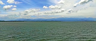
Sri Lanka, formerly called Ceylon, is an island nation in the Indian Ocean, southeast of the Indian subcontinent, in a strategic location near major sea lanes. The nation has a total area of 65,610 square kilometres (25,330 sq mi), with 64,630 square kilometres (24,950 sq mi) of land and 980 square kilometres (380 sq mi) of water. Its coastline is 1,340 kilometres (830 mi) long. The main island of Sri Lanka has an area of 64, 058 km2; it is the twenty-fifth largest island in the world by area. Dozens of offshore islands account for the remaining 1552 km2 area. The largest offshore island, Jaffna Island is separated by Chundikulam lagoon and Mannar Island, is linked to Adam's Bridge, a land connection to the Indian mainland, which is now mostly submerged with only a chain of limestone shoals remaining above sea level. According to temple records, this natural causeway was formerly whole, but was breached by a violent storm in 1480. The formation is also known as Rama's Bridge, as according to Hindu mythology, it was constructed during the rule of Lord Rama.
Soil retrogression and degradation are two regressive evolution processes associated with the loss of equilibrium of a stable soil. Retrogression is primarily due to soil erosion and corresponds to a phenomenon where succession reverts the land to its natural physical state. Degradation is an evolution, different from natural evolution, related to the local climate and vegetation. It is due to the replacement of primary plant communities by the secondary communities. This replacement modifies the humus composition and amount, and affects the formation of the soil. It is directly related to human activity. Soil degradation may also be viewed as any change or ecological disturbance to the soil perceived to be deleterious or undesirable.

Shifting cultivation is an agricultural system in which plots of land are cultivated temporarily, then abandoned while post-disturbance fallow vegetation is allowed to freely grow while the cultivator moves on to another plot. The period of cultivation is usually terminated when the soil shows signs of exhaustion or, more commonly, when the field is overrun by weeds. The period of time during which the field is cultivated is usually shorter than the period over which the land is allowed to regenerate by lying fallow.

Ecological succession is the process of change in the species that make up an ecological community over time.

Yala (යාල) National Park is the most visited and second largest national park in Sri Lanka, bordering the Indian Ocean. The park consists of five blocks, three of which are now open to the public. There are also two adjoining parks, Kumana National Park or 'Yala East' and Lunugamvehera National Park. The blocks have individual names, such as Palatupana. It is situated in the southeastern region of the country, in the Southern Province and Uva Province. The park covers 979 square kilometres (378 sq mi) and is located about 300 kilometres (190 mi) from Colombo. Yala was designated as a wildlife sanctuary in 1900, along with Wilpattu, designated in 1938, as the first two designated national parks in Sri Lanka. The park is best known for its variety of wildlife and is important conservation of Sri Lankan elephants, Sri Lankan leopards and aquatic birds.
Udawalawe National Park is a national park on the boundary of Sabaragamuwa and Uva Provinces in Sri Lanka. The park was created to provide a sanctuary for wild animals displaced by the construction of the Udawalawe Reservoir on the Walawe River, as well as to protect the catchment of the reservoir. The reserve covers 30,821 hectares (119.00 sq mi) of land area and was established on 30 June 1972.

A secondary forest is a forest or woodland area which has regenerated through largely natural processes after human-caused disturbances, such as timber harvest or agriculture clearing, or equivalently disruptive natural phenomena. It is distinguished from an old-growth forest, which has not recently undergone such disruption, and complex early seral forest, as well as third-growth forests that result from harvest in second growth forests. Secondary forest regrowing after timber harvest differs from forest regrowing after natural disturbances such as fire, insect infestation, or windthrow because the dead trees remain to provide nutrients, structure, and water retention after natural disturbances. Secondary forests are notably different from primary forests in their composition and biodiversity; however, they may still be helpful in providing habitat for native species, preserving watersheds, and restoring connectivity between ecosystems.

North Central Province is one of the nine provinces of Sri Lanka. The province has an area of 10,472 km2, making it the largest province by area, and a population of 1,266,663, making it the 3rd least populated province. The city of Anuradhapura is the capital of the province.

Garrigue or garigue, also known as phrygana, is a type of low scrubland ecoregion and plant community in the Mediterranean forests, woodlands, and scrub biome.

Secondary succession is the secondary ecological succession of a plant's life. As opposed to the first, primary succession, secondary succession is a process started by an event that reduces an already established ecosystem to a smaller population of species, and as such secondary succession occurs on preexisting soil whereas primary succession usually occurs in a place lacking soil. Many factors can affect secondary succession, such as trophic interaction, initial composition, and competition-colonization trade-offs. The factors that control the increase in abundance of a species during succession may be determined mainly by seed production and dispersal, micro climate; landscape structure ; bulk density, pH, and soil texture.

The primary form of agriculture in Sri Lanka is rice production. Rice is cultivated during Maha and Yala seasons. Tea is cultivated in the central highlands and is a major source of foreign exchange. Vegetables, fruits and oilseed crops are also cultivated in the country. There are two Agriculture Parks abbreviated as A. Parks established by the Department of Agriculture. Out of the total population in Sri Lanka, 27.1% engages in agricultural activities. Agriculture accounted for 7.4% of the GDP in 2020.
Old field is a term used in ecology to describe lands formerly cultivated or grazed but later abandoned. The dominant flora include perennial grasses, heaths and herbaceous plants. Old fields are canonically defined as an intermediate stage found in ecological succession in an ecosystem advancing towards its climax community, a concept which has been debated by contemporary ecologists for some time.
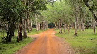
Wilpattu National Park is a national park in Sri Lanka. The unique feature of this park is the existence of "Willus" – natural, sand-rimmed water basins or depressions that fill with rainwater. Located on the northwest coast lowland dry zone of Sri Lanka, the park is 30 km (19 mi) west of Anuradhapura and 26 km (16 mi) north of Puttalam. The park is 1,317 km2 (508 sq mi) in area and ranges from 0–152 m (0–499 ft) above sea level. Nearly one hundred and six lakes (Willu) and tanks are found spread throughout Wilpattu. Wilpattu is the largest and one of the oldest national parks in Sri Lanka. Wilpattu is world-renowned for its leopard population. A remote camera survey conducted in Wilpattu from July to October 2015 by the Wilderness and Wildlife Conservation Trust captured photographs of forty-nine individual leopards in the surveyed area, the core area density of which was between that of Yala National Park's Block I and Horton Plains National Park.
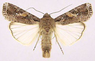
The fall armyworm is a species in the order Lepidoptera and one of the species of the fall armyworm moths distinguished by their larval life stage. The term "armyworm" can refer to several species, often describing the large-scale invasive behavior of the species' larval stage. It is regarded as a pest and can damage and destroy a wide variety of crops, which causes large economic damage. Its scientific name derives from frugiperda, which is Latin for lost fruit, named because of the species' ability to destroy crops. Because of its propensity for destruction, the fall armyworm's habits and possibilities for crop protection have been studied in depth. It is also a notable case for studying sympatric speciation, as it appears to be diverging into two species currently. Another remarkable trait of the larva is that they consistently practice cannibalism, despite its fitness costs.

Deforestation is one of the most serious environmental issues in Sri Lanka. Sri Lanka's current forest cover as of 2017 was 29.7%. In the 1920s, the island had a 49 percent forest cover but by 2005 this had fallen by approximately 26 percent. Between 1990 and 2000, Sri Lanka lost an average of 26,800 ha of forests per year. This amounts to an average annual deforestation rate of 1.14%. Between 2000 and 2005 the rate accelerated to 1.43% per annum. However, with a long history of policy and laws towards environmental protection, deforestation rates of primary cover have decreased 35% since the end of the 1990s thanks to a strong history of conservation measures. The problem of deforestation in Sri Lanka is not as significant in the southern mountainous regions as it is in northern and lowland southern Sri Lanka, largely due to the nature of environmental protection.

Anuradhapura Kingdom, named for its capital city, was the second established kingdom in ancient Sri Lanka related to the Sinhalese people. According to the Mahāvaṃsa, it was founded by King Pandukabhaya in 437 BC, whose authority extended throughout the country.

Ritigala is a mountain in central Sri Lanka which is home to an ancient Buddhist monastery. The ruins and rock inscriptions of the monastery date back to 1st century BCE. It is located 43 km (27 mi) away from the ancient monastic city of Anuradhapura.
Sugarcane is the only crop cultivated in Sri Lanka for manufacture of sugar. This crop can be growth on well drained soil up to an elevation of about 1,000 m (3,300 ft). Sugarcane has been cultivated in Sri Lanka since 19th century. About three decades ago, in the 1970s Sri Lanka was cultivated in about 25,000 ha. There were 3,840 ha in Kantale, 5,660 ha in Hingurana, 4,500 ha in Pelwatte, 4,680 ha in Seveanagala and 5,700 ha in Moneragala. At present, only Pelwatta and Sevanagala factories are functioning. Cultivation at Hingurana has started and it is likely that the factory will start production in 2010. Most of the lands cultivated with sugarcane are in the intermediate zone. Receiving annual rainfall of 1,250–2,000 mm (49–79 in) distributed in a bimodal pattern.
Sri Lanka exhibits a remarkable biological diversity and is considered to be the richest country in Asia in terms of species concentration.

The tank cascade system is an ancient Sri Lankan irrigation system. It is a network of thousands of small tanks draining to large reservoirs that store rainwater and surface runoff for later use. They make agriculture possible in the dry-zone, where periods of drought and flooding otherwise make it difficult to support paddy fields and livestock.