
The Merchants Avenue Historic District in a residential neighborhood southeast of the downtown in Fort Atkinson, Wisconsin, composed of 33 mostly large homes on large lots within six city blocks around Merchants Avenue. It was placed on the United States National Register of Historic Places in 1986.
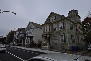
The North Bedford Historic District is a historic district roughly bounded by Summer, Parker, Pleasant and Kempton Streets in New Bedford, Massachusetts. It encompasses a predominantly residential neighborhood north of downtown New Bedford which was developed primarily in the mid 19th-century. It features a variety of worker housing of the period, as well as a number of higher quality houses built by businessmen. The district was added to the National Register of Historic Places in 1979.
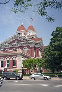
Crown Point Courthouse Square Historic District is a historic district in Crown Point, Indiana, that dates back to 1873. It was listed on the National Register of Historic Places in 2004. Its boundaries were changed in 2005, and it was increased in 2007 to include a Moderne architecture building at 208 Main Street. The late nineteenth- and early twentieth-century commercial and public buildings represent a period of economic and political growth. The Lake County Courthouse stands in the center of the district. Designed by architect John C. Cochrane in 1878, this brick building is a combination of Romanesque Revival and Classical styles. Enlarged in 1909 with the addition of north and south wings, designed by Beers and Beers. Continued growth in the county required second enlargement in 1928. This local landmark was placed in the National Register of Historic Places in 1973.

The Joliet East Side Historic District is a set of 290 buildings in Joliet, Illinois. Of these 290 buildings, 281 contribute to the historical integrity of the area. Joliet was founded in 1831, deemed an ideal place for a settlement to reap the local natural resources. Most importantly, large beds of limestone provided a strong economic incentive to develop the area. Several important structures were constructed with Joliet limestone, including the Old State Capitol and Chicago Water Tower. Joliet incorporated in 1852 and prospered due to its location on the Illinois and Michigan Canal.

The Bridge Avenue Historic District is located in a residential neighborhood on the east side of Davenport, Iowa, United States. It has been listed on the National Register of Historic Places since 1983. The historic district stretches from River Drive along the Mississippi River up a bluff to East Ninth Street, which is near the top of the hill.

The Central Geneva Historic District is a set of 102 buildings and structures in Geneva, Illinois. Of those, 68 contribute to the district's historical integrity. The district is representative of southern Geneva, south of Illinois Route 38. Among the noted buildings is the Kane County Courthouse and the Frank Lloyd Wright-designed P. D. Hoyt House. The district was added to the National Register of Historic Places in 1979, and was enlarged in 2017.
The Metamora Crossroads Historic District is a historic district centered at the intersection of Oak and High Street in the small village of Metamora in Metamora Township in Lapeer County, Michigan. It was designated as a Michigan State Historic Site and also added to the National Register of Historic Places on July 19, 1984.

The Piety Hill Historic District is a historic district located in downtown Lapeer in Lapeer County, Michigan. It was designated as a Michigan State Historic Site and also added to the National Register of Historic Places on July 26, 1985.

The West Saint Clair Street Historic District is a residential historic district located along 124–328 West Saint Clair Street in the village of Almont in Almont Township in southeast Lapeer County, Michigan. It was designated as a Michigan State Historic Site and also added to the National Register of Historic Places on May 8, 1986.

Equinunk Historic District is a national historic district located at Buckingham Township and Manchester Township, Wayne County, Pennsylvania. The district includes 55 contributing buildings and 1 contributing site in the community of Equinunk. The buildings are vernacular interpretations of a variety of popular 19th- and early-20th-century architectural styles including Greek Revival, Italianate, Gothic Revival, Second Empire, and Queen Anne. Notable buildings include Nelson's Store, Calder House, Nelson House, Barnes House (1901), Bullock's Store, Taft Hotel, Bleck's Hotel (1905), and Equinunk Methodist Church (1895). The contributing site is the Equinunk Cemetery.

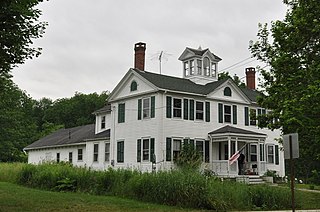
The North Charlestown Historic District encompasses a 19th-century rural village in Charlestown, New Hampshire. Located about 5 miles (8 km) north of the town's center, the district includes a small cluster of buildings along New Hampshire Route 12A that is a remnant portion of a larger agricultural village. First settled in the 1750s, the oldest buildings in the district date to the 1790s, and most of the major buildings were built in the 19th century. Its economy was based on lumber and farming. The village was once considered a much larger, dispersed settlement, but construction of New Hampshire Route 11 in the 1960s separated some of the more remote parts of the village from its nucleus, which was bypassed by that construction.

The Whitney Park Historic District is a residential historic district on the west side of Bangor, Maine. The district contains 42 residential properties built between 1850 and 1910, a major period of the city's growth, and is anchored on its south by Whitney Park, a small triangular park at Hammond and Cedar Streets. The district was listed on the National Register of Historic Places in 1988, and is protected by the city's local historic district ordinance.

The Archibald-Adams House is a historic house at 122 Main Street in Cherryfield, Maine, United States. Built about 1795, it is one of the town's oldest surviving buildings, with associations to two prominent local families. It is now the Englishmans Bed and Breakfast, and is listed on the National Register of Historic Places.
The Gen. Alexander Campbell House is a historic house on United States Route 1 in Cherryfield, Maine. Built in 1790, the originally Federal-style house underwent a number of alterations in 19th century, and now has a somewhat Victorian appearance. The house is notable for being built by Alexander Campbell, a leading figure of Down East Maine during the American Revolutionary War and the subsequent decades. The house was listed on the National Register of Historic Places in 1977, and is a contributing element of the Cherryfield Historic District.
The David W. Campbell House is a historic house on Main Street in Cherryfield, Maine. Built in 1828 as a Federal-style structure, it was altered in the mid-19th century to include a significant number of Italianate features. Built by a member of the locally prominent Campbell family, it was listed on the National Register of Historic Places in 1990 for its architectural significance, and is a contributing member of the 1990 Cherryfield Historic District.

The Col. Samuel Campbell House is a historic house on United States Route 1 in the village center of Cherryfield, Maine. Built in 1883, it is one of the finest examples of Queen Anne Victorian architecture in eastern Maine. The house was listed on the National Register of Historic Places in 1982, and is a contributing element of the 1990 Cherryfield Historic District.

The William M. Nash House is a historic house on River Road in Cherryfield, Maine. It is a multiply-altered and renovated structure, now presented as an elaborately decorated 1888 Second Empire house. This design was one of Cherryfield native William A. Allen's most imaginative designs. It was listed on the National Register of Historic Places in 1983, and is a contributing property to the Cherryfield Historic District. The property is owned by Gordon and Cynthia Kelley.

The Patten Building is a historic commercial building on Main Street in Cherryfield, Maine. Built in 1865, it is a fine example of commercial Italianate architecture, and has long been a landmark retail site in the small community.

The Oliver Street Historic District is a primarily residential historic district, located along Oliver Street between Third and Oak Street, as well as some adjacent sections of Williams and Goodhue Streets, in Owosso, Michigan. It was listed on the National Register of Historic Places in 1980.
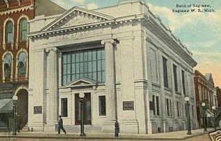
The Saginaw City Historic Business District is a primarily commercial historic district located between Michigan Avenue and the Saginaw River, from Cleveland to Van Buren Avenues, in Saginaw, Michigan. It was listed on the National Register of Historic Places in 1982.


