Clarendon | |
---|---|
Coordinates: 41°46′52″N79°5′42″W / 41.78111°N 79.09500°W Coordinates: 41°46′52″N79°5′42″W / 41.78111°N 79.09500°W | |
Country | United States |
State | Pennsylvania |
County | Warren |
Founded | 1872 |
Government | |
• Mayor | Tommy Eaton |
Area | |
• Total | 0.34 sq mi (0.87 km2) |
• Land | 0.34 sq mi (0.87 km2) |
• Water | 0.00 sq mi (0.00 km2) |
Population | |
• Total | 410 |
• Density | 1,216.62/sq mi (470.01/km2) |
Time zone | UTC-4 (EST) |
• Summer (DST) | UTC-5 (EDT) |
Area code | 814 |
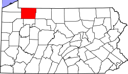
Clarendon is a borough in Warren County, Pennsylvania, United States. The population was 450 at the 2010 census.
Clarendon is located at 41°46′52″N79°5′42″W / 41.78111°N 79.09500°W (41.781091, -79.095090). [3]
According to the United States Census Bureau, the borough has a total area of 0.4 square miles (1.0 km2), all land.
Historical population | |||
---|---|---|---|
Census | Pop. | %± | |
1880 | 295 | — | |
1890 | 1,297 | 339.7% | |
1900 | 1,092 | −15.8% | |
1910 | 933 | −14.6% | |
1920 | 928 | −0.5% | |
1930 | 938 | 1.1% | |
1940 | 824 | −12.2% | |
1950 | 748 | −9.2% | |
1960 | 825 | 10.3% | |
1970 | 735 | −10.9% | |
1980 | 776 | 5.6% | |
1990 | 650 | −16.2% | |
2000 | 564 | −13.2% | |
2010 | 450 | −20.2% | |
2020 | 410 | −8.9% | |
Sources: [4] [5] [6] [2] |
As of the census [5] of 2000, there were 564 people, 220 households, and 150 families residing in the borough. The population density was 1,308.6 people per square mile (506.4/km2). There were 239 housing units at an average density of 554.5 per square mile (214.6/km2). The racial makeup of the borough was 97.52% White, 0.18% Native American, 1.06% Asian, and 1.24% from two or more races. Hispanic or Latino of any race were 1.06% of the population.
There were 220 households, out of which 32.7% had children under the age of 18 living with them, 55.9% were married couples living together, 8.6% had a female householder with no husband present, and 31.8% were non-families. 26.8% of all households were made up of individuals, and 15.5% had someone living alone who was 65 years of age or older. The average household size was 2.56 and the average family size was 3.10.
In the borough the population was spread out, with 27.1% under the age of 18, 8.5% from 18 to 24, 26.4% from 25 to 44, 20.9% from 45 to 64, and 17.0% who were 65 years of age or older. The median age was 36 years. For every 100 females there were 98.6 males. For every 100 females age 18 and over, there were 97.6 males.
The median income for a household in the borough was $27,750, and the median income for a family was $30,313. Males had a median income of $29,083 versus $21,625 for females. The per capita income for the borough was $13,774. About 11.8% of families and 15.5% of the population were below the poverty line, including 23.9% of those under age 18 and 10.0% of those age 65 or over.
Lydia is an unincorporated community and census-designated place (CDP) in Iberia Parish, Louisiana, United States. The population was 952 at the 2010 census, down from 1,079 at the 2000 census. It is part of the New Iberia Micropolitan Statistical Area.
Oakwood is a village in Paulding County, Ohio, United States. The population was 608 at the 2010 census.
North Apollo is a borough in Armstrong County, Pennsylvania, United States. The population was 1,297 at the 2010 census.
Eau Claire is a borough in Butler County, Pennsylvania, United States. The population was 316 at the 2010 census. The name means "Clear Water" in French, and the name is pronounced as though it were spelled "U'Clare".
Fairview is a borough in Butler County, Pennsylvania, United States. The population was 198 at the 2010 census. It should not be confused with Fairview in Erie County, which carries the ZIP code 16415.
Petrolia is a borough in Butler County, Pennsylvania, United States. The population was 212 at the 2010 census.
Hawthorn is a borough in Clarion County, Pennsylvania, United States. The population was 482 at the 2020 census.
Shippenville is a borough in Clarion County, Pennsylvania, United States. The population was 446 at the 2020 census.
Summerville is a borough in Jefferson County, Pennsylvania, United States. The population was 528 at the 2010 census.
Barkeyville is a borough in Venango County, Pennsylvania, United States. The population was 186 at the 2020 census.
Clintonville is a borough in Venango County, Pennsylvania, United States. The population was 437 at the 2020 census.
Cooperstown is a borough in Venango County, Pennsylvania, United States. The population was 460 at the 2010 census.
Rouseville is a borough in Venango County, Pennsylvania, United States. The population was 456 at the 2020 census.
Sugarcreek is a borough in Venango County, Pennsylvania, United States. The population was 4,824 at the 2020 census. It is the largest borough by total area in all Venango County.
Utica is a borough in Venango County, Pennsylvania, United States. The population was 184 at the 2020 census.
Bear Lake is a borough in Warren County, Pennsylvania, United States. The population was 193 at the 2000 census.
Sugar Grove is a borough in Warren County, Pennsylvania, United States. The population was 614 at the 2010 census.
Youngsville is a borough in Warren County, Pennsylvania, United States. The population was 1,729 at the 2010 census.
Madison is a borough in Westmoreland County, Pennsylvania, United States. The population was 397 at the 2010 census. The borough was named for James Madison, 4th President of the United States.
Oklahoma is a borough in Westmoreland County, Pennsylvania, United States. The population was 809 at the 2010 census.