Clarkville, New Zealand

Last updated

Clarkville
Clarkville, New Zealand
Coordinates: 43°24′21″S172°37′34″E / 43.40571°S 172.626226°E / -43.40571; 172.626226
Country New Zealand
Region Canterbury
Territorial authority Waimakariri District
Ward
  • Oxford-Ohoka Ward
  • Kaiapoi-Woodend Ward
Community
  • Oxford-Ohoka Community
  • Kaiapoi-Woodend Community
Electorates
Government
  Territorial Authority Waimakariri District Council
  Regional council Environment Canterbury
   Mayor of Waimakariri Dan Gordon
   Waimakariri MP Matthew Doocey
   Te Tai Tonga MP Tākuta Ferris
Area
[1]
  Total30.13 km2 (11.63 sq mi)
Population
 (June 2023) [2]
  Total1,520
  Density50/km2 (130/sq mi)
Time zone UTC+12 (NZST)
  Summer (DST) UTC+13 (NZDT)
Postcode
7692
Area code 03
Local iwi Ngāi Tahu

Clarkville is a small rural town in the Waimakariri District, New Zealand. As of June 2023, Clarkville had a population of 1,520. [2]

Contents

History

Clarkville was originally known as Kaiapoi Island, because it was in between two equally large branches of the Waimakariri River. This led to the area being flooded often by the unpredictable Waimakariri River. In the 1860s, farmers cut a new course for the river and choked the north branch, rendering it just a stream, known today as Silverstream, of which the Silverstream Estate (where Mitre 10 Dream Home 2013 was located) was named after. In 1880, the name was changed to Clarkville, in honour of Joseph Clark, who donated land for the local school.
In 1919, The Clarkville Hall Association, Incorporated, erected a community hall. [3] It is called the Clarkville Peace Hall, and still stands today, along with an enlargement in 1970.

Education

Clarkville School is Clarkville's only school, and was established in 1874. [4] It is a decile 9 state co-educational full primary, with 178 students (as of February 2024). [5]

Demographics

The Clarkville statistical area covers 30.13 km2 (11.63 sq mi). [1] It had an estimated population of 1,520 as of June 2023, [2] with a population density of 50 people per km2.

Historical population
YearPop.±% p.a.
1901253    
20061,122+1.43%
20131,320+2.35%
20181,401+1.20%
Source: [6] [7]

Before the 2023 census, the statistical area had a larger boundary, covering 30.17 km2 (11.65 sq mi). [1] Using that boundary, Clarkville had a population of 1,401 at the 2018 New Zealand census, an increase of 81 people (6.1%) since the 2013 census, and an increase of 279 people (24.9%) since the 2006 census. There were 471 households, comprising 723 males and 675 females, giving a sex ratio of 1.07 males per female. The median age was 46.1 years (compared with 37.4 years nationally), with 264 people (18.8%) aged under 15 years, 225 (16.1%) aged 15 to 29, 681 (48.6%) aged 30 to 64, and 231 (16.5%) aged 65 or older.

Ethnicities were 92.9% European/Pākehā, 7.9% Māori, 1.3% Pasifika, 3.2% Asian, and 1.5% other ethnicities. People may identify with more than one ethnicity.

The percentage of people born overseas was 14.1, compared with 27.1% nationally.

Although some people chose not to answer the census's question about religious affiliation, 52.2% had no religion, 39.2% were Christian, 0.2% were Muslim, 0.6% were Buddhist and 0.9% had other religions.

Of those at least 15 years old, 222 (19.5%) people had a bachelor's or higher degree, and 171 (15.0%) people had no formal qualifications. The median income was $40,900, compared with $31,800 nationally. 297 people (26.1%) earned over $70,000 compared to 17.2% nationally. The employment status of those at least 15 was that 591 (52.0%) people were employed full-time, 243 (21.4%) were part-time, and 24 (2.1%) were unemployed. [7]

Climate

The average temperature in summer is 16.6 °C, and in winter is 6.4 °C. [8]

MonthNormal temperature
January17.2 °C
February16.7 °C
March15.2 °C
April12.2 °C
May8.8 °C
June6.2 °C
July5.8 °C
August7.1 °C
September9.4 °C
October11.8 °C
November13.9 °C
December15.9 °C

Related Research Articles

<span class="mw-page-title-main">Kaiapoi</span> Town in Canterbury, New Zealand

Kaiapoi is a town in the Waimakariri District of the Canterbury region, in the South Island of New Zealand. The town is located approximately 17 kilometres north of central Christchurch, close to the mouth of the Waimakariri River. It is considered a satellite town of Christchurch and is part of the Christchurch functional urban area. The town is named after the nearby Kaiapoi Pā.

<span class="mw-page-title-main">Silverstream</span> Suburb of Upper Hutt City, New Zealand

Silverstream is a suburb of Upper Hutt in New Zealand, just under 7 km (4.3 mi) south-west of the Upper Hutt CBD. It is in the lower (southern) part of the North Island of New Zealand at the southern end of Upper Hutt, close to the Taitā Gorge, which separates Upper Hutt from Lower Hutt. The area is sited at the mouth of a small valley formed by the Wellington Region's tectonic activity and, in part, by Hull's Creek, which discharges into the Hutt River.

<span class="mw-page-title-main">Waimakariri District</span> Territorial authority district in South Island, New Zealand

Waimakariri District is a local government district, located in the Canterbury Region of New Zealand's South Island. It is named after the Waimakariri River, which forms the district's southern boundary, separating it from Christchurch City and the Selwyn District. It is bounded in the north by the Hurunui District and in the east by the Pacific Ocean.

<span class="mw-page-title-main">Pinehaven</span> Suburb of Upper Hutt, New Zealand

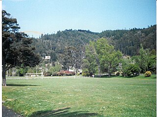
Pinehaven is a suburb of Upper Hutt City in the lower North Island of New Zealand, established in 1927. It is at the southern end of the city, within the pine covered hills east of Silverstream.

Heretaunga is a suburb of the city of Upper Hutt, located in the lower (southern) North Island of New Zealand. Heretaunga adjoins the suburb of Silverstream to its southwest and the two are commonly thought of associated with each other. To the northeast lies Trentham. The Heretaunga Railway Station on the Hutt Valley Line serves the suburb.

<span class="mw-page-title-main">Fernside, New Zealand</span> Rural area in Canterbury, New Zealand

Fernside is a small rural community in the Waimakariri District, New Zealand. In 1901, Fernside had a population of 550. As of the 2006 New Zealand census, Fernside has a population of 1491.

Pamapuria is a locality in Northland, New Zealand. It lies on State Highway 1 about 10 km east of Kaitaia.

Otaika is a suburb of Whangārei 7 km south of the city in Northland, New Zealand. The Otaika Stream runs from the north west, through the area, and into the Whangārei Harbour. State Highway 1 runs through the locality. The hill Tikorangi lies to the South. Tikorangi is a source of limestone for Portland Cement.

<span class="mw-page-title-main">Cust, New Zealand</span> Town in Canterbury, New Zealand

Cust is a rural village in the South Island of New Zealand. It is located in North Canterbury and comes under seat of the Waimakariri District Council. It is located approximately 16 km east of Oxford and 17 km west of Rangiora. The town is named after Sir Edward Cust, who was a member of the Canterbury Association which organised European settlement of the area around 1850. Earlier names for the town were Moeraki Downs and Middleton-on-the-Cust.

<span class="mw-page-title-main">The Pines Beach</span> Human settlement in Waimakariri District, Canterbury Region, New Zealand

The Pines Beach is a small town situated roughly 4 km east of Kaiapoi in the Canterbury region of the South Island of New Zealand. It is 1 km north of the mouth of the Waimakariri River. It takes its name from its close proximity to both a pine forest and the beach.

<span class="mw-page-title-main">Arundel, New Zealand</span> Rural village in Canterbury, New Zealand

Arundel is a small rural village about 15 kilometres (9 mi) north of Geraldine, in the Canterbury region in the South Island of New Zealand. It is near the south bank of the Rangitata River, 3 kilometres (2 mi) from Peel Forest, an extensive podocarp forest with abundant birdlife. Arundel is flat and fertile, with fields and many mature trees.

<span class="mw-page-title-main">Eyrewell Forest</span> Rural area in Canterbury, New Zealand

Eyrewell Forest is a small rural area in the Waimakariri District, New Zealand.

<span class="mw-page-title-main">Kairaki</span> Settlement in Canterbury, New Zealand

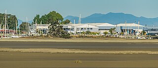
Kairaki is a small rural community in the Waimakariri District, New Zealand.

<span class="mw-page-title-main">Sefton, New Zealand</span> Town in Canterbury, New Zealand

Sefton is a small town in the Waimakariri District, New Zealand, about 23 miles from Christchurch.

Mandeville North is a small village in the Waimakariri District of Canterbury, New Zealand. Due to new subdivisions being built in the area, the population has been slowly increasing, particularly after the 2011 Christchurch earthquake. The construction of the Mandeville village retail development began in late 2017 and was completed in early 2018.

<span class="mw-page-title-main">Kainga, New Zealand</span> Settlement in Canterbury, New Zealand

Kainga is a settlement on the southern bank of the Waimakariri River, just north of Christchurch, in Canterbury, New Zealand. It lies immediately to the south of Kaiapoi, on a small road leading northeast from State Highway 1.

<span class="mw-page-title-main">Lower Moutere</span> Rural locality in Tasman, New Zealand

Lower Moutere is a settlement in the Tasman District of New Zealand's upper South Island. It is a farming community it the Lower Moutere valley, 6 km (3.7 mi) from Motueka close to the Moutere Inlet.

<span class="mw-page-title-main">Woodend Beach</span> Rural settlement in Canterbury, New Zealand

Woodend Beach is a small rural community in the Waimakariri District, New Zealand.

McLeans Island is a rural area north and northwest of Christchurch city, and south of Waimakariri River.

Hadlow is a rural community in the Timaru District, New Zealand. It is located west of Timaru and south of Pleasant Point.

References

  1. 1 2 3 "ArcGIS Web Application". statsnz.maps.arcgis.com. Retrieved 13 April 2024.
  2. 1 2 3 "Population estimate tables - NZ.Stat". Statistics New Zealand . Retrieved 25 October 2023.
  3. "Clarkville peace hall". Ministry for Culture and Heritage. Retrieved 28 November 2013.
  4. "Clarkville Primary School" . Retrieved 27 November 2013.
  5. "New Zealand Schools Directory". New Zealand Ministry of Education. Retrieved 14 March 2024.
  6. "CLARKVILLE". THE CYCLOPEDIA OF NEW ZEALAND. Retrieved 14 December 2013.
  7. 1 2 "Statistical area 1 dataset for 2018 Census". Statistics New Zealand. March 2020. Clarkville (315500). 2018 Census place summary: Clarkville
  8. "Weather statistics for Clarkville, Canterbury (New Zealand)". yr.no. Retrieved 28 November 2013.