
The Presidential Range is a mountain range located in the White Mountains of the U.S. state of New Hampshire. Containing the highest peaks of the Whites, its most notable summits are named for American presidents, followed by prominent public figures of the 18th and 19th centuries. The Presidential Range is notorious for having some of the worst weather on Earth, mainly because of the unpredictability of high wind speeds and whiteout conditions on the higher summits. Because of the poor weather conditions, the Presidential Range is often used for mountaineering training for those who go on to climb some of the world's highest mountains, including K2 and Everest.

The North Downs are a ridge of chalk hills in south east England that stretch from Farnham in Surrey to the White Cliffs of Dover in Kent. Westerham Heights, at the northern edge of the North Downs, near Bromley, South London, is the highest point in London at an elevation of 245 m (804 ft). The North Downs lie within two Areas of Outstanding Natural Beauty (AONBs), the Surrey Hills and the Kent Downs. The North Downs Way National Trail runs along the North Downs from Farnham to Dover.
The Piedmont is a plateau region located in the Eastern United States. It sits between the Atlantic coastal plain and the main Appalachian Mountains, stretching from New Jersey in the north to central Alabama in the south. The Piedmont Province is a physiographic province of the larger Appalachian division which consists of the Gettysburg-Newark Lowlands, the Piedmont Upland and the Piedmont Lowlands sections.

Divis is a large mountain and area of sprawling moorland to the north-west of Belfast in County Antrim, Northern Ireland. The mountain is 1,568 ft tall, making it the highest of the Belfast Hills. It extends north to the Antrim Plateau and shares its geology; consisting of a basaltic cover underlain by limestone and lias clay.

The Talladega National Forest is located in the U.S. state of Alabama and covers 392,567 acres at the southern edge of the Appalachian Mountains.

Lost Maples State Natural Area is a large, pristine area of beautiful hills and canyons on the upper Sabinal River in the Edwards Plateau Region of Texas. It is designated a Natural Area, rather than a State Park, which means the primary focus is the maintenance and protection of the property's natural state. Accordingly, access and recreational activities may be restricted if the Texas Parks & Wildlife Department (TPWD) deems such action necessary to protect the environment.

A mudflow or lahar is a form of mass wasting involving "very rapid to extremely rapid surging flow" of debris that has become partially or fully liquified by the addition of significant amounts of water to the source material.

Mount Clay is a peak located in Thompson and Meserve's Purchase in Coos County in the Presidential Range of the White Mountains of New Hampshire. It is a rise about 0.9-mile (1.4 km) long and a few hundred feet tall, with summit elevation of 5,533 feet (1,686 m); it lies on the ridge joining the summits of Mount Washington, about 0.9-mile (1.4 km) to the south-southeast, with that of Mount Jefferson, about 1.3-mile (2.1 km) north.

Tumamoc Hill is a butte located immediately west of "A" Mountain and downtown Tucson, Arizona. It is home to many radio, television, and public safety transmitters. The 860-acre ecological reserve and U.S. National Historic Landmark was established by the Carnegie Institution in 1903. The University of Arizona (UA) owns a 340-acre (1.4 km2) preserve and leases another 509 acres (2.06 km2) as a research and education facility. The Steward Observatory maintains a small astronomical observatory with a 20-inch (510 mm) telescope on the hill. Besides being a prominent landmark, Tumamoc Hill has a long and varied history, and is currently an important site for ecological and anthropological research as well as a refuge and a recreational option for the people of Tucson. The Desert Laboratory located on Tumamoc welcomed a new director, Ben Wilder, as of 2018.
The Nantahala National Forest, established in 1920, is a national forest located in the American state of North Carolina. The word "Nantahala" is a Cherokee word meaning "Land of the Noonday Sun." The name is appropriate as, in some spots, the sun only reaches the floors of the deep gorges of the forest when high overhead at midday. The Spanish Conquistador Hernando de Soto explored the area in 1540, as did William Bartram in the 18th century. The Nantahala River flows through the Nantahala National Forest.
The geography of Texas is diverse and large. Occupying about 7% of the total water and land area of the U.S., it is the second largest state after Alaska, and is the southernmost part of the Great Plains, which end in the south against the folded Sierra Madre Oriental of Mexico. Texas is in the south-central part of the United States of America, and is considered to form part of the U.S. South and also part of the U.S. Southwest.

Clay Hill is an area of Enfield, London, England. It is located to the north of Enfield Town and is mainly a residential area which almost borders Crews Hill to the north and forms part of London's Green Belt. Places of interest include Clay Hill House, Whitewebbs Park, Hillyfields Park and Forty Hall. The North Enfield Cricket Club ground is located within the Clay Hill area, at the top of Hilly Fields Park.

Chiojdu is a commune in the northwestern hill and mountainside region of Buzău County, Romania. Made up of six villages on the bank of the Bâsca Chiojdului River, a small tributary to Buzău River, it is the center of a region known for the good preservation of old traditions and folk art, especially the particular architectural style of the houses.
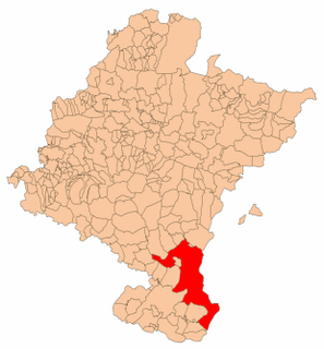
The Bardenas Reales is a semi-desert natural region, or badlands, of some 42,000 hectares in southeast Navarre (Spain). The soils are made up of clay, chalk and sandstone and have been eroded by water and wind creating surprising shapes, canyons, plateaus, tabular structures and isolated hills, called cabezos. Bardenas lacks urban areas, vegetation is scarce and the many streams that cross the territory have a markedly seasonal flow, staying dry most of the year.
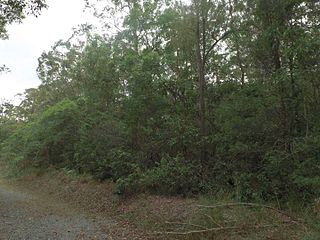
Nerang National Park is a national park in Queensland, Australia situated on the Gold Coast. The protected area is located 12 kilometres (7.5 mi) from Surfers Paradise on Nerang’s north-west outskirts.

Negro Hill is a mountain located in the Catskill Mountains of New York northeast of Roxbury. Roundtop is located south-southwest, Clay Hill is located east and Ferris Hill is located northwest of Negro Hill.
Red Hill is a mountain located in the Catskill Mountains of New York east-south of Frost Valley. Woodhull Mountain is located northeast of Red Hill.

Clay Hill is a mountain in Barnstable County, Massachusetts. It is located 1.8 miles (2.9 km) south-southeast of West Barnstable in the Town of Barnstable. Shootflying Hill is located east and White Hill is located north of Clay Hill.

Van Loan Hill is a mountain in Greene County, New York. It is located in the Catskill Mountains southwest of Maplecrest. Round Hill is located west, Elm Ridge is located north-northeast, and East Jewett Range is located south of Van Loan Hill.


