
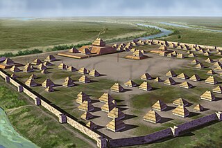
Aztalan State Park is a Wisconsin state park in the Town of Aztalan, Jefferson County, at latitude N 43° 4′ and longitude W 88° 52′. Established in 1952, it was designated a National Historic Landmark in 1964 and added to the National Register of Historic Places in 1966. The park covers 172 acres along the Crawfish River.

Wickliffe Mounds is a prehistoric, Mississippian culture archaeological site located in Ballard County, Kentucky, just outside the town of Wickliffe, about 3 miles (4.8 km) from the confluence of the Ohio and Mississippi rivers. Archaeological investigations have linked the site with others along the Ohio River in Illinois and Kentucky as part of the Angel Phase of Mississippian culture. Wickliffe Mounds is controlled by the State Parks Service, which operates a museum at the site for interpretation of the ancient community. Listed on the National Register of Historic Places, it is also a Kentucky Archeological Landmark and State Historic Site.

Moccasin Bend Archeological District is an archeological site in Chattanooga, Tennessee, that is part of the Chickamauga and Chattanooga National Military Park unit. The National Park Service refers to it as one of the "most unique units found in the entire National Park Service." The area contains remnants of 12,000 years of continuous human habitation and therefore serves as a fascinating area with a rich history and unique cultural significance. For many years, there was little recognition of the historical significance of the area, and years of industrial development occurred on and around sites of archeological importance. After decades of campaigning by concerned citizens, private organizations, local officials, the Friends of Moccasin Bend National Park, and finally a state representative, the area was officially recognized as a National Archeological District in 2003. Moccasin Bend is currently undergoing a process of renovation and restoration that will allow the area to fulfill the National Park Service's mission of preserving "natural and cultural resources" for the "enjoyment, education, and inspiration of this and future generations."

The Hickory Ridge Cemetery Archeological Site (8ES1280) is an archaeological site in Pensacola, Escambia County Florida. It is located north of Big Lagoon and west of Pensacola. During excavations in the 1980s carbon dating was done on burnt wood fragments associated with burials in the mound, with a determination that the site had been used c. 1450. Analysis of ceramics suggested it was a Mississippian culture site, probably from the Late Bottle Creek Phase or Early Bear Point Phases of the Pensacola culture. It was a cemetery associated with a village nearby, (8ES1052). On September 22, 2000, it was added to the U.S. National Register of Historic Places.

The Nodena Site is an archeological site east of Wilson, Arkansas and northeast of Reverie, Tennessee in Mississippi County, Arkansas, United States. Around 1400–1650 CE an aboriginal palisaded village existed in the Nodena area on a meander bend of the Mississippi River. The Nodena site was discovered and first documented by Dr. James K. Hampson, archaeologist and owner of the plantation on which the Nodena site is located. Artifacts from this site are on display in the Hampson Museum State Park in Wilson, Arkansas. The Nodena Site is the type site for the Nodena Phase, believed by many archaeologists to be the province of Pacaha visited by Spanish explorer Hernando de Soto in 1542.

The Eaker Site (3MS105) is an archaeological site on Eaker Air Force Base near Blytheville, Arkansas that was declared a National Historic Landmark in 1996. The site is the largest and most intact Late Mississippian Nodena Phase village site within the Central Mississippi Valley, with archaeological evidence indicating a palisaded village some 50 acres (20 ha) in size, with hundreds of structures. The site's major period of occupation was 1350–1450 CE, although evidence of occupation dates back to 600 CE. The site is also hypothesized to have been occupied by the Quapaw prior to a migration further south, after which they made contact with Europeans in the late 17th century.
Parkin Archeological State Park, also known as Parkin Indian Mound, is an archeological site and state park in Parkin, Cross County, Arkansas. Around 1350–1650 CE an aboriginal palisaded village existed at the site, at the confluence of the St. Francis and Tyronza rivers. Artifacts from this site are on display at the site museum. The Parkin Site is the type site for the Parkin phase, an expression of the Mississippian culture from the Late Mississippian period. Many archeologists believe it to be part of the province of Casqui, documented as visited by Spanish explorer Hernando de Soto in 1542. Archeological artifacts from the village of the Parkin people are dated to 1400–1650 CE.

Bottle Creek Indian Mounds (1BA2) is an archaeological site owned and monitored by the Alabama Historical Commission located on a low swampy island within the Mobile-Tensaw River Delta north of Mobile, Alabama, United States. It was occupied by the peoples of the Pensacola culture, a regional Mississippian culture variant, and is the largest site of the Mississippian culture on the central Gulf Coast. It is important to understanding the history and culture of the Mobile-Tensaw delta in late prehistoric times and was designated as a National Historic Landmark on March 10, 1995, making it one of only two such sites in Alabama.

The Emerald Mound Site, also known as the Selsertown site, is a Plaquemine culture Mississippian period archaeological site located on the Natchez Trace Parkway near Stanton, Mississippi, United States. The site dates from the period between 1200 and 1730 CE. It is the type site for the Emerald Phase of the Natchez Bluffs Plaquemine culture chronology and was still in use by the later historic Natchez people for their main ceremonial center. The platform mound is the second-largest Mississippian period earthwork in the country, after Monk's Mound at Cahokia, Illinois.

The Winterville Site is a major archaeological site in unincorporated Washington County, Mississippi, north of Greenville and along the river. It consists of major earthwork monuments, including more than twelve large platform mounds and cleared and filled plazas. It is the type site for the Winterville Phase of the Lower Yazoo Basin region of the Plaquemine Mississippian culture. Protected as a state park, it has been designated as a National Historic Landmark.
The Liddell Archeological Site is a prehistoric Native American site in Wilcox County, Alabama. The site covers 50 acres (20 ha) and shows evidence of human occupation from 9000 BC to 1800 AD. It is best known for its Mississippian artifacts, primarily from the Burial Urn Culture period. The site was first documented in the 1960s, when the United States Army Corps of Engineers constructed Millers Ferry Lock and Dam on the Alabama River, creating the William "Bill" Dannelly Reservoir. The Liddell, Stroud, and Hall families donated the site to Auburn University after its discovery. It was added to the National Register of Historic Places on November 17, 1978.

The C.H. Nash Museum at Chucalissa is located on and exhibits excavated materials of the Mississippian culture archaeological site known as Chucalissa which means "abandoned house" in Choctaw. The site is located adjacent to the T. O. Fuller State Park within the city of Memphis, Tennessee, United States. Chucalissa was designated National Historic Landmark in 1994 due to its importance as one of the best-preserved and major prehistoric settlement sites in the region.

Boone's Mounds are a ceremonial site of the Coles Creek culture located in Calhoun County, Arkansas. The site is one of the largest mound sites in the Ouachita River valley. Archeological excavation at the site has yielded dates of occupation as early as 600 AD, and it may still have been in use during the early contact period, c. 1700. The site was located on private property at the time of its listing on the National Register of Historic Places in 1980.

The Lunsford-Pulcher Archeological Site is a prehistoric archaeological site in rural Monroe and St. Clair counties in Illinois. The site was the location of a Middle Mississippian village which was probably a satellite community of Cahokia. Several pyramidal burial mounds are included in the site. Archaeological excavations at the site have also discovered the remains of houses and garden beds, making the site one of the few Mississippian villages at which garden beds have been found. The site has been known to European settlers since early settlement of the area in the late 18th century; despite being used for farmland, the site remains in good condition.

The Spikebuck Town Mound and Village Site is a prehistoric and historic archaeological site on Town Creek near its confluence with the Hiwassee River within the boundaries of present-day Hayesville, North Carolina. The site encompasses the former area of the Cherokee village of Quanassee and associated farmsteads. The village was centered on what is known as Spikebuck Mound, an earthwork platform mound, likely built about 1,000 CE by ancestral indigenous peoples during the South Appalachian Mississippian culture period.
The Adamson Mounds Site (38KE11) is an archaeological site located near Camden, Kershaw County, South Carolina. It is a prehistoric Native American village site containing one large platform mound, a smaller mound, possibly a third still smaller mound, and a burial area. It served as a regional ceremonial center. This site represents a widespread, late prehistoric Mississippian culture known by the names of Lamar, Irene, or Pee Dee and dates probably between AD 1400 and AD 1700.
Nununyi was a historic village of the Cherokee people in western North Carolina, located on the eastern side of the Oconaluftee River. Today it is within the boundaries of the present-day city of Cherokee in Swain County. It was classified by English traders and colonists as among the "Out Towns" of the Cherokee in this area east of the Appalachian Mountains.

The Seven Mile Island Archeological District is an archeological site on an island in the Tennessee River in Colbert and Lauderdale County, Alabama. The island is believed to have been inhabited for about 9,000 years, with the earliest artifacts dated to the early Archaic Period. Out of 18 sites identified on the island, two have had extensive study. The Perry Site (1Lu25) is a seven-foot (2.1-meter) thick midden containing ceramic potsherds from the Archaic period. The Seven Mile Island site (1Lu21) is a Mississippian village site and mound. A number of arrowheads and flint knives, as well as a bottle with an engraved bird have been found at the site. 41 burials from the Mississippian era were also unearthed.
The Rock Creek Archeological District is a pair of archaeological sites near Maud, Colbert County, Alabama. The sites contain remnants from the Archaic, Gulf Formational, Woodland, and Mississippian Periods. One of the sites, ACt 44, shows evidence of two major habitations, a hunting camp from the Late Archaic period and a Late Mississippian farm village, although ceramics and arrowheads from other eras have also been recovered. Most artifacts from the other site, ACt 45, date from the Gulf Formational period. The sites were discovered by National Park Service archaeologist A. Wayne Prokopetz in 1975, with major surveys being completed by Christopher E. Hamilton in 1977 and by Memphis State University researchers in 1980. The district was listed on the National Register of Historic Places in 1990.
Archeological Site 3PP141 is a prehistoric rock art site in Pope County, Arkansas. The art at the site, which is on state-owned land, is believed to have been painted during the period of the Mississippian culture. The 28 drawings at this site are part of a larger collection within the state that are expected to improve the understanding of Mississippian religious practices during that time.


