Covendo | |
|---|---|
Village | |
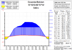 Climate chart in the Walter and Lieth format, metric, °Celsius und millimeters, made with Geoklima 2.1 | |
 Covendo Location within Bolivia | |
| Coordinates: 15°50′S66°57′W / 15.833°S 66.950°W | |
| Country | |
| Department | La Paz Department |
| Province | Sud Yungas Province |
| Municipality | Palos Blancos Municipality |
| Elevation | 1,697 ft (517 m) |
| Population (2001) | |
• Total | 517 |
| Time zone | UTC-4 (BOT) |
Covendo is a village in the La Paz Department of Bolivia. It is in the valley of the upper Beni River (Alto Beni) in the Bolivian Andes. [1] [2]
In 2001 it had a population of 517. [3]
It is served by Covendo Airport.
