Cycle Superhighway 3

Last updated

CS3 logo.png
Cycle Superhighway 3
C3 at Hyde Park Corner.jpg
Cycle Superhighway 3 at Hyde Park Corner
Route information
NetworkCycleways
Length14.9 miles (24 km)
DirectionEast–West
OpenedJuly 2010
Managed by Transport for London
Area Served City of Westminster
City of London
Tower Hamlets
Newham
Barking and Dagenham
Technical
SegregationFully segregated
Track typeLong distance cycle route

Cycle Superhighway 3 (CS3) is a cycle path in London, United Kingdom. It is part of the Cycleway network coordinated by TfL. It runs from Barking in the east to Lancaster Gate in central London. [1] [2] [3] It is a popular route with both commuter and leisure cyclists, passing a number of major destinations in London along its route. [1] For almost the entire route, cyclists are separated from other traffic in segregated cycle lanes, and cycling infrastructure has been provided at major interchanges. CS3 will be renamed to Cycleway 3 (C3). [4]

Contents

Route

CS3 begins in Barking and ends at Lancaster Gate in the City of Westminster. [1] [2]

Barking to Leamouth

CS3 begins to the south of Greatfields Park in Barking, at the intersection between River Road and the A13 (Alfred's Way). The beginning of the Superhighway can be found at the southern side of the junction as a narrow, two-way cycle track signed "Cycle Superhighway (CS3)" towards Canning Town (25 mins), Canary Wharf (35 mins) and Tower Gateway (55 mins). The journey times are signposted and calculated by TfL. [5] The cycle track is coloured blue.

Heading westbound, the blue cycle track is intermittent, sharing its space with the pedestrian footpath. This continues for around 500 metres before the blue, two-way track returns as a constant feature running in parallel with the A13, separated from the main carriageway by a kerb.

CS3 and the A13 cross the Barking Creek alongside one another, at the same time crossing from Barking and Dagenham into Newham. After crossing Barking Creek, CS3 branches southwards so as to avoid clashing with traffic at the busy junction between the A13, the A406/North Circular and A1020.

Having passed beneath the A1020/Royal Docks Road, CS3 continues to run parallel to the A13 (Newham Way), segregated from traffic on the main carriageway. On this section, the Superhighway passes through Beckton, where there is a short cycle link southwards towards Beckton DLR station, and then to the east of Canning Town station, before running in parallel to the A13 once more to cross Bow Creek. The entirety of this section through Newham is shared with route 13 of the 1980s-era London Cycle Network.

Cycle Superhighway 3 at Cable Street Cable Street cycle superhighway.jpg
Cycle Superhighway 3 at Cable Street

Leamouth to Tower Gateway

To the west of Bow Creek, CS3 enters Tower Hamlets and heads south of East India Dock Road (A13) into Leamouth on the western pavement of Leamouth Road. Still signposted but no longer a blue cycle track, CS3 then heads westbound on Sorrel Lane, southbound on Oregano Drive, then westbound on Saffron Avenue. Cyclists share road space with other traffic in this more residential area.

CS3 passes through Poplar, just north of Canary Wharf, sharing Poplar High Street with other road traffic. At the western end of Poplar High Street, the Superhighway continues along Ming Street and Premiere Place, passing Westferry DLR station to the north. Continuing westbound, CS3 follows Limehouse Causeway and Narrow Street, briefly running parallel to the River Thames.

Still signposted, CS3 then heads roughly north, joining Cable Street at its eastern terminus.

On Cable Street, the Superhighway is segregated from other road traffic on a narrow, two-way cycle track. The track itself pre-dates the Cycle Superhighway, constructed as part of the London Cycle Network, [6] but CS3 introduced wayfinding and blue surfacing to aid routefinding. The Superhighway runs the entire length of Cable Street, passing both the Cable Street Mural and Shadwell DLR and London Overground stations.

CS3 leaves Tower Hamlets on Royal Mint Street, entering the City of London.

Tower Gateway to Lancaster Gate

The Superhighway crosses London's Inner Ring Road near Tower Gateway station. Tower Bridge and the Tower of London are visible to the south of CS3. Entering the City of London, CS3 is a wide cycle track segregated from other road traffic. This remains the case until CS3 reaches the Palace of Westminster.

In the City, the Superhighway avoids the busy centre, instead running in parallel to the Thames. Remaining segregated from other traffic, CS3 meets C6 in a grade-separated junction at Blackfriars. At this point, the Superhighway crosses Victoria Embankment, following the Embankment until it reaches its southern terminus at the Palace of Westminster and Westminster Bridge. CS3 crosses the boundary between the City of London and the City of Westminster.

CS3 passes under C6 at Blackfriars. Cycle superhighway 6 at Blackfriars.jpg
CS3 passes under C6 at Blackfriars.

At the end of Victoria Embankment, CS3 heads westbound on Bridge Street, again as a wide, segregated cycle track, passing Parliament Square on its northernmost edge. CS3 then passes several government offices as it continues westbound, running along the entire length of Birdcage Walk (the southern boundary of St. James's Park).

CS3 then heads briefly north, passing Buckingham Palace, before continuing westbound again on Constitution Hill as a segregated bike freeway. The Superhighway then passes through the middle of Hyde Park Corner, sharing space with pedestrians.

Leaving Hyde Park Corner to the north, CS3 heads sharply westbound along a wide bike freeway which runs along the southern edge of Hyde Park (South Carriage Drive). At the end of the Drive, CS3 heads sharply northbound, following West Carriage Drive to its terminus at Lancaster Gate.

The beginning of CS3 at Lancaster Gate is signposted towards Hyde Park Corner (11 mins), Westminster (20 mins) and Kensington.

Destinations

Barking and Dagenham

Newham

Tower Hamlets

City of London

City of Westminster

History

CS3 was constructed in 3 sections:

  1. Barking to Tower Gateway in the east, opened July 2010 [7]
  2. Tower Gateway to Parliament Square, opened April 2016 [8]
  3. Parliament Square to Lancaster Gate in the west, opened September 2018 [9]

The route which became known as CS3 was originally proposed by the former Mayor of London Ken Livingstone. In 2008, Livingstone proposed a "cycling transformation in London," at the same time announcing the "biggest investment in cycling in London's history." CS3 was one of the original twelve "motorways of cycling," and was designed to take cyclists along the route it currently occupies from Barking to Lancaster Gate. It was proposed that CS3 would then join up with two further superhighways - CS9 and CS10 - to extend the network in to West London. [10] [11]

When Boris Johnson became mayor in 2008, he proceeded with a modified Cycle Superhighways plan, which retained some of these radial routes, including the Barking to Tower Gateway CS3 as one of the first 2 routes to be delivered. [7] But Johnson's plan initially excluded any major routes through the very centre of London. This decision to drop the central London routes was reversed 4 years later with a manifesto commitment made by Johnson in the 2012 London elections, which followed criticism of the design quality of the first Cycle Superhighways to be delivered, and a high profile campaign by London Cycling Campaign calling for upgrades and for the missing links across central London. [12] Johnson dubbed this central section of the route a "Crossrail for cyclists," hoping to create a "cleaner, safer, greener city." [13]

Related Research Articles

Paddington Human settlement in England

Paddington is an area within the City of Westminster, in central London. First a medieval parish then a metropolitan borough, it was integrated with Westminster and Greater London in 1965. Three important landmarks of the district are Paddington station, designed by the engineer Isambard Kingdom Brunel and opened in 1847; St Mary's Hospital; and the former Paddington Green Police Station.

Poplar, London Area of East London, England

Poplar is a district in East London, England, the administrative centre of the borough of Tower Hamlets. Five miles (8 km) east of Charing Cross, it is part of the East End.

Stratford, London Human settlement in England

Stratford is a town in east London, England, within the ceremonial county of Greater London and the historic county of Essex. Part of the Lower Lea Valley, Stratford is situated 6 miles (10 km) east-northeast of Charing Cross, and includes the localities of Maryland, East Village, Mill Meads and Stratford City.

London Borough of Barking and Dagenham Borough in United Kingdom

The London Borough of Barking and Dagenham is a London borough in East London. It lies around 9 miles (14.4 km) east of Central London. It is an Outer London borough and the south is within the London Riverside section of the Thames Gateway; an area designated as a national priority for urban regeneration. At the 2011 census it had a population of 187,000, the majority of which are within the Becontree estate. The borough's three main towns are Barking, Chadwell Heath and Dagenham. The local authorities are the Barking and Dagenham London Borough Councils. Barking and Dagenham was one of six London boroughs to host the 2012 Summer Olympics.

London Borough of Newham Borough of London, England

The London Borough of Newham is a London borough created in 1965 by the London Government Act 1963. It covers an area previously administered by the Essex county boroughs of West Ham and East Ham, authorities that were both abolished by the same act. The name Newham reflects its creation and combines the compass points of the old borough names. Situated on the borders of inner and outer East London, Newham has a population of 353,134, which is the third highest of the London boroughs and also makes it the 20th most populous district in England. The local authority is Newham London Borough Council.

Plaistow, Newham Town in East London, England

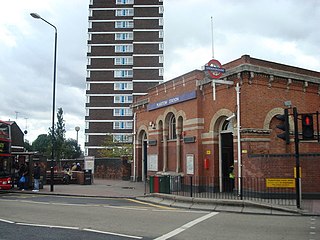
Plaistow is a suburban town in East London, England, within the London Borough of Newham. It adjoins Upton Park to the north, East Ham to the east, Beckton to the south, Canning Town to the south-west and Three Mills to the west.

Canary Wharf Major business and financial district in London, England

Canary Wharf is an area of London, England, located on the Isle of Dogs in the London Borough of Tower Hamlets. Canary Wharf is defined by the Greater London Authority as being part of London's central business district, alongside Central London. With the City of London, it constitutes one of the main financial centres in the United Kingdom and the world, containing many high-rise buildings including the third-tallest in the UK, One Canada Square, which opened on 26 August 1991.

Hyde Park, London Royal Park in London, United Kingdom

Hyde Park is a Grade I-listed major park in Central London. It is the largest of four Royal Parks that form a chain from the entrance of Kensington Palace through Kensington Gardens and Hyde Park, via Hyde Park Corner and Green Park past the main entrance to Buckingham Palace. The park is divided by the Serpentine and the Long Water lakes.

Canning Town station London Underground and Docklands Light Railway station

Canning Town is a London Underground, Docklands Light Railway (DLR) and London Buses station in Canning Town in London, England. It is designed as an intermodal metro and bus station, fully opening in 1999 as part of the Jubilee Line Extension - replacing the original station site north of the A13. On 11 November 2015, the Mayor of London announced that it would be rezoned to be on the boundary of Travelcard Zone 2 and Travelcard Zone 3.

Tower Hill tube station London Underground station

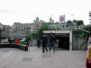
Tower Hill is a London Underground station in Tower Hill in the East End of London. It is on the Circle line between Monument and Aldgate stations, and the District line between Monument and Aldgate East. Tower Hill is within Travelcard zone 1 and is a short distance from Tower Gateway station for the Docklands Light Railway, Fenchurch Street station for National Rail mainline services, and Tower Millennium Pier for River Services.

Lancaster Gate tube station London Underground station

Lancaster Gate is a London Underground station located on the Central line near Lancaster Gate on Bayswater Road in Paddington, to the north of Kensington Gardens. It is between Queensway and Marble Arch on the Central line and is in Travelcard Zone 1.

A11 road (England) Road in England

The A11 is a major trunk road in England. It runs roughly north east from London to Norwich, Norfolk, although after the M11 opened in the 1970s and then the A12 extension in 1999, a lengthy section has been downgraded between the suburbs of east London and the north-west corner of the county of Essex. It also multiplexes/overlaps with the A14 on the Newmarket bypass.

A13 road (England) Major road in England

The A13 is a major road in England linking Central London with east London and south Essex. Its route is similar to that of the London, Tilbury and Southend line via Rainham, Grays, Tilbury & Stanford-Le-Hope, and runs the entire length of the northern Thames Gateway area, terminating on the Thames Estuary at Shoeburyness. It is a trunk road between London and the Tilbury junction, a primary route between there and Sadlers Hall Farm near South Benfleet, and a non-primary route between there and Shoeburyness.

Mile End Area in the East End of London, England

Mile End is a district of the London Borough of Tower Hamlets in the East End of London, England, 3.6 miles (5.8 km) east-northeast of Charing Cross. Situated on the London-to-Colchester road, it was one of the earliest suburbs of London. It became part of the metropolitan area in 1855, and is connected to the London Underground.

A201 road

The A201 is an A road in London running from Kings Cross to Bricklayer's Arms.

A202 road

The A202 is a primary A road in London. It runs from New Cross Gate to London Victoria station. A section of the route forms a part of the London Inner Ring Road between Vauxhall and Victoria, known as Vauxhall Bridge Road.

Cycling in London Overview of cycling in London, England

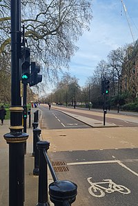
Cycling in London is a popular mode of transport and leisure activity within the capital city of the United Kingdom. Following a national decline in the 1960s of levels of utility cycling, cycling as a mode of everyday transport within London began a slow regrowth in the 1970s. This continued until the beginning of the 21st century, when levels began to increase significantly - during the period from 2000 to 2012, the number of daily journeys made by bicycle in Greater London doubled to 580,000. The growth in cycling can partly be attributed to the launch in 2010 by Transport for London (TfL) of a cycle hire system throughout the city's centre. By 2013, the scheme was attracting a monthly ridership of approximately 500,000, peaking at a million rides in July of that year. Health impact analyses have shown that London would benefit more from increased cycling and cycling infrastructure than other European cities.

Angel, London Human settlement in England

Angel is an area on the northern fringes of central London within the London Borough of Islington. It is 2 miles (3.2 km) north-northeast of Charing Cross on the Inner Ring Road at a busy transport intersection. The area is identified in the London Plan as one of 35 major centres in London. It is a significant commercial and retail centre, and a business improvement district. It is named after the former Angel Inn which stood on the corner of Islington High Street and Pentonville Road.

Bow Interchange

Bow Interchange is a busy grade-separated road junction in London, England, on the East Cross Route between Bow, Stratford, and Bromley-by-Bow at a point where the London Boroughs of Tower Hamlets and Newham meet. It is a triple-level junction where the East Cross Route, Bow Road, and Stratford High Street meet. The River Lea runs underneath the junction.

References

  1. 1 2 3 "East-West Cycle Superhighway (CS3) - Tower Hill to Lancaster Gate - Route alignment" (PDF). Transport for London . Archived from the original (PDF) on 28 March 2018. Retrieved 1 May 2021.
  2. 1 2 "OpenStreetMap - Relation: Cycle Superhighway 3 (1159230)". OpenStreetMap . 31 December 2018. Retrieved 1 May 2021.
  3. "Cycle superhighways". London Cycling Campaign . Archived from the original on 1 February 2021. Retrieved 1 May 2021.
  4. "Tooley Street and Duke Street Hill". Consultations. Transport for London . Retrieved 1 May 2021.
  5. "Cycle journey time reliability" (PDF). Road Network Performance & Research. Transport for London . Traffic Note 11. August 2009. Retrieved 1 May 2021.
  6. "On Your Bike". EastEndHomes News. Vol. 8. August 2008. p. 6. Retrieved 1 May 2021.
  7. 1 2 "Mayor launches London's first two Barclays Cycle Superhighway routes". Transport for London . 19 July 2010. Retrieved 1 May 2021.
  8. "East-west London cycle superhighway 'to open on 30 April'". BBC News . 7 March 2016. Retrieved 1 May 2021.
  9. "Major new Cycle Superhighway extension opens in the heart of London". London City Hall . 20 September 2018. Retrieved 1 May 2021.
  10. Taylor, Matthew (9 February 2008). "City's two-wheel transformation". The Guardian . ISSN   0261-3077 . Retrieved 1 May 2021.
  11. Becket, Adam (27 March 2017). "I cycled the length of all London's Cycling Superhighways. Here's what I learnt". CityMetric . Archived from the original on 28 October 2020. Retrieved 1 May 2021.
  12. "Gearing up for cycling safety". London City Hall . 21 November 2012. Retrieved 1 May 2021.
  13. Lydall, Ross (7 March 2016). "Opening date announced for new £47m cycle superhighway". Evening Standard . Retrieved 1 May 2021.