Dallas City, Illinois

Last updated

Dallas City, Illinois
IL9wIL96ewSigns-DallasCity (24543641097).jpg
IL 9 and IL 96 intersect in downtown Dallas City
Henderson County Illinois Incorporated and Unincorporated areas Dallas City Highlighted.svg
Location of Dallas City in Henderson County, Illinois.
Illinois in United States (US48).svg
Location of Illinois in the United States
Coordinates: 40°38′12″N91°9′55″W / 40.63667°N 91.16528°W / 40.63667; -91.16528
CountryUnited States
StateIllinois
Counties Hancock, Henderson
Townships Dallas City, Pontoosuc, Lomax
Area
[1]
  Total3.28 sq mi (8.48 km2)
  Land2.37 sq mi (6.15 km2)
  Water0.90 sq mi (2.33 km2)
Elevation
[2]
584 ft (178 m)
Population
 (2020)
  Total805
  Density339.09/sq mi (130.90/km2)
Time zone UTC-6 (CST)
  Summer (DST) UTC-5 (CDT)
ZIP Code(s)
62330
Area code 217
FIPS code 17-18420
GNIS feature ID2393708 [2]
Wikimedia CommonsDallas City, Illinois
Website www.dallascity-il.com

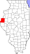
Dallas City is a city in Hancock and Henderson counties in the U.S. state of Illinois. The population in 2020 stands at an estimate of 805, a decline from the 2010 census of 945, [3] which was a decline from 1,055 in 2000.

Contents

The Hancock County portion of Dallas City is part of the Fort Madison Keokuk, IA IL MO Micropolitan Statistical Area, and the Henderson County portion of Dallas City is part of the Burlington, IAIL Micropolitan Statistical Area.

History

According to historical records, a man named Israel Atherton purchased the land around present-day Dallas City in 1836. He built a log cabin but he didn't seem to stay very long. He sold the land to John Finch, who built a village, which today is still recognized as, Dallas City. [4] It was laid out in 1848, and named in honor of George Mifflin Dallas, 11th Vice President of the United States of America, from 1845 to 1849. [5] A post office has been in operation at Dallas City since 1850. [6]

Abraham Lincoln Monument

On October 23, 1858, Abraham Lincoln stopped in Dallas City, Illinois to deliver a speech. Many local men were instrumental in persuading Lincoln to visit Dallas in 1858, including George M. Ames, H.F. Black, and Ben Mendenhall. According to the Dallas City Review newspaper, several efforts were made by Democrats to tear down the platform that had been erected for Lincoln to use during his speech. Republican forces, however, were present and did not allow it to happen. A monument to represent Lincoln's visit sits on the Mississippi River on the Riverfront Park at the end of Oak St. [7]

Stone site where Abraham Lincoln gave his speech. Lincoln Spoke Here - Dallas City Illinois (42910308392).jpg
Stone site where Abraham Lincoln gave his speech.

There was supposed to be two stones with bronze plaques, one for Lincoln's visit, the other for President James Polk along with his Vice-President, George M Dallas. There is no information given as to why that other plaque was not included on the stone, but it is assumed Lincoln's was more impactful. [9]

The day before (October 22, 1858), Lincoln had spoken at the second courthouse made in Hancock County, the county Dallas City is a part of, to residents as he and Stephen A. Douglas were running against one another for the US Senate. [10]

Geography

Dallas City is located at 40°38′12″N91°9′55″W / 40.63667°N 91.16528°W / 40.63667; -91.16528 (40.636565, -91.165256). [11]

According to the 2021 census gazetteer files, Dallas City has a total area of 3.28 square miles (8.50 km2), of which 2.37 square miles (6.14 km2) (or 72.47%) is land and 0.90 square miles (2.33 km2) (or 27.53%) is water. [12]

Demographics

Historical population
CensusPop.Note
1870 78
1880 829962.8%
1890 747−9.9%
1900 97029.9%
1910 1,28832.8%
1920 1,140−11.5%
1930 1,114−2.3%
1940 1,1493.1%
1950 1,27511.0%
1960 1,2760.1%
1970 1,2840.6%
1980 1,4089.7%
1990 1,037−26.3%
2000 1,0551.7%
2010 945−10.4%
2020 805−14.8%
U.S. Decennial Census [13]

As of the 2020 census [14] there were 805 people, 464 households, and 290 families residing in the city. The population density was 245.73 inhabitants per square mile (94.88/km2). There were 471 housing units at an average density of 143.77 per square mile (55.51/km2). The racial makeup of the city was 96.02% White, 0.25% African American, 0.37% Native American, 0.50% Asian, 0.00% Pacific Islander, 0.00% from other races, and 2.86% from two or more races. Hispanic or Latino of any race were 0.75% of the population.

There were 464 households, out of which 29.1% had children under the age of 18 living with them, 42.24% were married couples living together, 13.79% had a female householder with no husband present, and 37.50% were non-families. 34.48% of all households were made up of individuals, and 15.30% had someone living alone who was 65 years of age or older. The average household size was 2.77 and the average family size was 2.24.

The city's age distribution consisted of 25.2% under the age of 18, 4.6% from 18 to 24, 21.9% from 25 to 44, 28.9% from 45 to 64, and 19.4% who were 65 years of age or older. The median age was 44.4 years. For every 100 females, there were 111.1 males. For every 100 females age 18 and over, there were 90.4 males.

The median income for a household in the city was $47,857, and the median income for a family was $66,500. Males had a median income of $34,402 versus $35,302 for females. The per capita income for the city was $26,409. About 7.9% of families and 14.7% of the population were below the poverty line, including 19.0% of those under age 18 and 11.2% of those age 65 or over.

Transportation

Amtrak’s Southwest Chief , which operates between Los Angeles and Chicago, passes through the town on BNSF tracks, but makes no stop. The nearest station is located in Fort Madison, 8 miles (13 km) to the west.

Education

Dallas Elementary School District 327 operates the public elementary school; it formerly was known as Dallas City Community School District #336.

Dallas City High School Dallas City High School.jpg
Dallas City High School

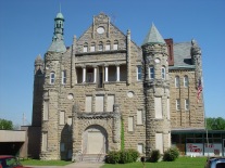
Although there is no exact date other than the early 1900s, the Dallas City High School was opened. The design of the building imitates the making of a castle. The school's nickname and mascot were the "Bulldogs", and their colors were red and black. The school's athletic teams did not fall far from greatness. Within the time it was open, the boy's teams won a total of 12 regional championships, 6 of which were earned in the 1940s. [16]

In 2001 Dallas City High School closed and was converted into the Great River Community Center; the city government installed additional parking in front of the former high school. The Dallas City area was reassigned to Nauvoo-Colusa Community Unit School District 325 for high school, so that year 70 students and all but two of the Dallas City High teachers moved to Nauvoo-Colusa High School. [17] In 2008 the Nauvoo-Colusa district closed its high school and redirected students to Warsaw Community Unit School District 316's Warsaw High School. [18] Upon promoting from the eighth grade, students attend high school at Illini West in Carthage, Illinois.

Related Research Articles

<span class="mw-page-title-main">Hancock County, Illinois</span> County in Illinois, United States

Hancock County is a county in the U.S. state of Illinois. According to the 2020 census, it has a population of 17,620. Its county seat is Carthage, and its largest city is Hamilton. The county is composed of rural towns with many farmers.

<span class="mw-page-title-main">Colusa, California</span> City in California, United States

Colusa is a city and county seat of Colusa County, California, located in the Sacramento Valley region of the Central Valley. The population was 5,971 at the 2010 census, up from 5,402 at the 2000 census. Colusi originates from the local Coru Native American tribe, who in the 1840s lived on the opposite side of the Sacramento River.

<span class="mw-page-title-main">Breese, Illinois</span> City in Illinois, United States

Breese is a city in Clinton County, Illinois, United States. Breese is the most populous city completely within Clinton County. As of the 2020 census, the population was 4,641, the majority of whom are of German ancestry. Breese is part of the Metro-East region of the Greater St. Louis metropolitan area.

<span class="mw-page-title-main">Matteson, Illinois</span> Village in Illinois, United States

Matteson is a village in Cook County, Illinois, United States. The population was 19,073 at the 2020 census. It is a suburb of Chicago.

<span class="mw-page-title-main">Robinson, Illinois</span> City in Illinois, United States

Robinson is a city in and the county seat of Crawford County, Illinois, United States. The population was 7,150 at the 2020 census, down from 7,713 at the 2010 census.

<span class="mw-page-title-main">Tuscola, Illinois</span> City in Illinois, United States

Tuscola is a city in Douglas County, Illinois, United States. The population was 4,636 at the 2020 census. It is the county seat of Douglas County.

<span class="mw-page-title-main">Batavia, Illinois</span> City in Illinois, United States

Batavia is a city mainly in Kane County and partly in DuPage County in the U.S. state of Illinois. Located in the Chicago metropolitan area, it was founded in 1833 and is the oldest city in Kane County. Per the 2020 census, the population was 26,098.

<span class="mw-page-title-main">Augusta, Illinois</span> Village in Illinois, United States

Augusta is a village in southeast Hancock County, Illinois, United States. The population was 587 at the 2010 census, down from 657 at the 2000 census. It is located near Weinberg-King State Park.

<span class="mw-page-title-main">Bentley, Illinois</span> Town in Illinois, United States

Bentley is an incorporated town in southeast Hancock County, Illinois, United States. The population was 35 at the 2010 census.

<span class="mw-page-title-main">Carthage, Illinois</span> City in Illinois, United States

Carthage is a city in and the county seat of Hancock County, Illinois, United States. Its population was 2,490 as of the 2020 census. Carthage is best known for being the site of the 1844 death of Joseph Smith, who founded the Latter Day Saint movement.

<span class="mw-page-title-main">Hamilton, Illinois</span> Place in Illinois, United States

Hamilton is a city in Hancock County, Illinois, United States. The population was 2,753 at the 2020 census, a decline from 2,951 in 2010. The city is located directly across the Mississippi River from Keokuk, Iowa. Hamilton is the largest city in Hancock County.

<span class="mw-page-title-main">La Harpe, Illinois</span> City in Illinois, United States

La Harpe is a town in Hancock County, Illinois, United States. The population was 1,235 at the 2010 census, down from 1,385 at the 2000 census.

<span class="mw-page-title-main">Nauvoo, Illinois</span> City in Illinois, United States

Nauvoo is a small city in Hancock County, Illinois, United States, on the Mississippi River near Fort Madison, Iowa. The population of Nauvoo was 950 at the 2020 census. Nauvoo attracts visitors for its historic importance and its religious significance to members of several groups: The Church of Jesus Christ of Latter-day Saints; the Community of Christ, formerly the Reorganized Church of Jesus Christ of Latter-day Saints (RLDS); other groups stemming from the Latter Day Saint movement; and the Icarians. The city and its immediate surrounding area are listed on the National Register of Historic Places as the Nauvoo Historic District.

<span class="mw-page-title-main">Pontoosuc, Illinois</span> Village in Illinois, United States

Pontoosuc is a village in Hancock County, Illinois, United States. The population was 146 at the 2010 census, down from 171 at the 2000 census.

<span class="mw-page-title-main">Warsaw, Illinois</span> City in Illinois, United States

Warsaw is a city in Hancock County, Illinois, United States. The population was 1,607 at the 2010 census, a decline from 1,793 in 2000. The city is notable for its historic downtown.

<span class="mw-page-title-main">Bethany, Illinois</span> Village in Illinois, United States

Bethany is a village in Moultrie County, Illinois, United States. The population was 1,255 at the 2020 census, down from 1,352 in 2010.

<span class="mw-page-title-main">Dallas City Township, Hancock County, Illinois</span> Township in Illinois, United States

Dallas City Township is one of twenty-five townships in Hancock County, Illinois, USA. As of the 2010 census, its population was 996 and it contained 502 housing units. It was formed from Pontoosuc Township in 1860.

The Fort Madison–Keokuk, IA-IL-MO Micropolitan Statistical Area, as defined by the United States Census Bureau, locally known as the "Tri-State" area, was an area consisting of three counties – one in southeast Iowa, one in northeast Missouri, and one in west central Illinois, anchored by the cities of Fort Madison, Iowa and Keokuk, Iowa. As of the 2010 census, the μSA had a population of 62,105. An estimate by the Census Bureau, as of July 1, 2012, placed the population at 61,477, a decrease of 1.01%. When the 2023 definitions were released this area was dissolved with Lee County, Iowa being included as part of the Burlington–Fort Madison, IA–IL Combined Statistical Area.

Colusa is an unincorporated community in Dallas City Township, Hancock County, Illinois, United States. Colusa is 5 miles (8.0 km) south of Dallas City. Colusa has a post office with ZIP code 62329.

Nauvoo–Colusa Community Unit School District 325 is a school district headquartered in Appanoose Township, just east of Nauvoo, Illinois. It serves northwestern Hancock County, including the city of Nauvoo and the unincorporated community of Colusa.

References

  1. "2020 U.S. Gazetteer Files". United States Census Bureau. Retrieved March 15, 2022.
  2. 1 2 U.S. Geological Survey Geographic Names Information System: Dallas City, Illinois
  3. "Geographic Identifiers: 2010 Demographic Profile Data (G001): Dallas City city, Illinois". American Factfinder. U.S. Census Bureau. Retrieved June 12, 2017.[ dead link ]
  4. Klinkenberg, Dean (August 28, 2015). "Dallas City". Mississippi Valley Traveler. Retrieved November 29, 2022.
  5. Callary, Edward (September 29, 2008). Place Names of Illinois. University of Illinois Press. p. 86. ISBN   978-0-252-09070-7.
  6. "Hancock County". Jim Forte Postal History. Retrieved November 3, 2015.
  7. "Politics and Lincoln Historical Marker". www.hmdb.org. Retrieved October 2, 2022.
  8. "File:Lincoln Spoke Here - Dallas City Illinois (42910308392).jpg" by formulanone from Huntsville, United States is licensed under CC BY-SA 2.0.
  9. "History - Dallas City". www.dallascity-il.com. Retrieved October 16, 2022.
  10. "Carthage, Hancock County, IL, USA". illinois.outfitters.com. Retrieved October 16, 2022.
  11. "US Gazetteer files: 2010, 2000, and 1990". United States Census Bureau. February 12, 2011. Retrieved April 23, 2011.
  12. Bureau, US Census. "Gazetteer Files". Census.gov. Retrieved June 29, 2022.
  13. "Census of Population and Housing". Census.gov. Retrieved June 4, 2015.
  14. "Explore Census Data". data.census.gov. Retrieved June 28, 2022.
  15. "City of Dallas City, Illinois". www.dallascity-il.com. Retrieved November 29, 2022.
  16. "The Dallas City "Bulldogs"". leopardfan.tripod.com. Retrieved November 29, 2022.
  17. Dutton, Natalie (August 15, 2001). "Nauvoo-Colusa High School ready for 70 students from Dallas City". Hancock County Journal-Pilot . Retrieved March 29, 2017.
  18. Vance, Diane (MVM News Network) (February 12, 2008). "Voters approve Warsaw/Nauvoo-Colusa deactivation plans". Hancock County Journal-Pilot . Retrieved March 29, 2017.