
Warminster Heights is a census-designated place and part of Warminster Township in Bucks County, Pennsylvania, USA. It is located near the east border of Hatboro, Montgomery County, Pennsylvania. The population was 4,124 at the 2010 census.

Aston Township is a township in Delaware County, Pennsylvania, United States. The population was 16,592 at the 2010 census.

Chester Heights is a borough in Delaware County, Pennsylvania, United States. The population was 2,531 at the 2010 census. Most of the borough lies south of U.S. 1, about a mile southwest of Wawa.

Clifton Heights is a borough in Delaware County, Pennsylvania, United States, located on Darby Creek 5 miles (8 km) west of downtown Philadelphia. As of the 2010 census the population was 6,652.

Concord Township is a township in Delaware County, Pennsylvania, United States. The population was 17,231 at the 2010 census. It contains the unincorporated communities of Concordville and Glen Mills.

Cornwells Heights is a census-designated place located in Bensalem Township in Bucks County, Pennsylvania. The community was formerly part of Cornwells Heights-Eddington, but was split into two separate CDP's. As of the 2010 census, the population was 1,391. The Cornwells Heights station is located in the community and serves SEPTA Regional Rail's Trenton Line and Amtrak's Keystone Service and Northeast Regional services along the Northeast Corridor. The train station also has a park-and-ride with access from Interstate 95.
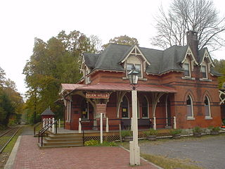
Glen Mills is an unincorporated community in Concord Township, Delaware County, Pennsylvania, United States about 27 miles west of Philadelphia. The ZIP code for Glen Mills is 19342.

Gwinhurst is an unincorporated community in New Castle County, Delaware, United States. Its altitude is 98 feet (30 m), and it is located at 39°47′30″N75°28′44″W.

Yorklyn is an unincorporated community in northern New Castle County, Delaware, United States. It lies along Delaware Route 82 northwest of the city of Wilmington, the county seat of New Castle County. Its elevation is 174 feet (53 m). It has a post office with the ZIP code 19736.
Buckingham Heights is an unincorporated community in New Castle County, Delaware, United States. Buckingham Heights is located southeast of Delaware Route 3 and southwest of Arden.
McDaniel Heights is an unincorporated community in New Castle County, Delaware, United States. McDaniel Heights is located east of U.S. Route 202 between Fairfax and Talleyville.
Claymont Heights is an unincorporated community in New Castle County, Delaware, United States. Claymont Heights is located along Harvey Road northwest of U.S. Route 13 Business in the southwestern part of Claymont.
Silverside Heights is an unincorporated community in New Castle County, Delaware, United States. Silverside Heights is located north of the intersection of U.S. Route 13 Business and Silverside Road northeast of Wilmington and southwest of Claymont.
Shipley Heights is an unincorporated community in New Castle County, Delaware, United States. Shipley Heights is located northwest of the intersection of Shipley Road and Weldin Road to the northeast of Wilmington.
Phillips Heights is an unincorporated community in New Castle County, Delaware, United States. Phillips Heights is located east of the intersection of U.S. Route 13 Business and Marsh Road northeast of Wilmington.
Gordon Heights is an unincorporated community in New Castle County, Delaware, United States. Gordon Heights is located east of the intersection of Delaware Route 3 and Marsh Road north of Edgemoor.
Cleland Heights is an unincorporated community in New Castle County, Delaware, United States. Cleland Heights is located to the north of Delaware Route 4 just southwest of the Wilmington city limit.
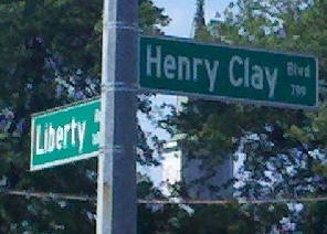
Liberty Heights is a neighborhood in southeastern Lexington, Kentucky, United States. Its boundaries are Winchester Road to the north, New Circle Road to the east, and R. J. Corman railroad tracks to the west and south.
Belvedere is an unincorporated community in New Castle County, Delaware, United States. Belvedere is at the junction of Delaware Route 62 and Delaware Route 141 north of Newport and south of Prices Corner, 7 miles (11 km) from downtown Wilmington. Belvedere uses the Wilmington ZIP code of 19804.

Auburn Valley State Park is a state park, located in Yorklyn, Delaware, United States. The park, which is around 360 acres, preserves the former home and estate of the Marshall family as well as portions of the family's former mills alongside the Red Clay Creek and additional land purchased by the state. The preserve contains several miles of trails open to walking, biking, and antique cars, and the state owns conservation easements on 160 acres of privately owned land adjacent to the park to help maintain the park's rural character.


