
A Regierungsbezirk means "governmental district" and is a type of administrative division in Germany. Four of sixteen Bundesländer are split into Regierungsbezirke. Beneath these are rural and urban districts.

The Marienwerder Region was a government region (Regierungsbezirk) of Prussia from 1815 until 1920 and again 1939-1945. It was a part of the Province of West Prussia from 1815 to 1829, and again 1878–1920, belonging to the Province of Prussia in the intervening years, and to the Reichsgau Danzig-West Prussia in the years 1939-1945. The regional capital was Marienwerder in West Prussia.

Reichsgau Danzig-West Prussia was an administrative division of Nazi Germany created on 8 October 1939 from annexed territory of the Free City of Danzig, the Greater Pomeranian Voivodship, and the Regierungsbezirk West Prussia of Gau East Prussia.

The Frontier March of Posen-West Prussia was a province of Prussia from 1922 to 1938. Posen-West Prussia was established in 1922 as a province of the Free State of Prussia within Weimar Germany, formed from merging three remaining non-contiguous territories of Posen and West Prussia, which had lost the majority of their territory to the Second Polish Republic and Free City of Danzig in the Treaty of Versailles. From 1934, Posen-West Prussia was de facto ruled by Brandenburg until it was dissolved by Nazi Germany, effective 1 October 1938 and its territory divided between the Prussian provinces of Pomerania, Brandenburg and Silesia. Schneidemühl was the provincial capital. Today, the province is entirely contained within the modern state of Poland.
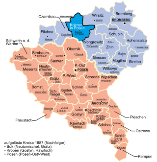
The Kreis Kolmar in Posen was a district in the northern government region of Bromberg, in the Prussian Province of Posen, from 1818 to 1920. The district capital was Kolmar in Posen.

Złotów is a town in northwestern Poland, with a population of 18,303 inhabitants (2011). Today it is part of Greater Poland Voivodeship (province), previously being in Piła Voivodeship (1975–1998). Since 1999 Złotów has been the seat of Złotów County.

The Province of Posen was a province of the Kingdom of Prussia from 1848 to 1920. Posen was established in 1848 following the Greater Poland Uprising as a successor to the Grand Duchy of Posen, which in turn was annexed by Prussia in 1815 from Napoleon's Duchy of Warsaw. It became part of the German Empire in 1871. After World War I, Posen was briefly part of the Free State of Prussia within Weimar Germany, but was dissolved in 1920 when most of its territory was ceded to the Second Polish Republic by the Treaty of Versailles, and the remaining German territory was later re-organized into Posen-West Prussia in 1922.

Drawsko Pomorskie is a town in the West Pomeranian Voivodeship, in northwestern Poland. It is the administrative seat of Drawsko County and the urban-rural commune of Gmina Drawsko Pomorskie. As of December 2021, the town has a population of 11,292. It is home to the Drawsko Training Ground, one of the largest training areas in Poland.
The Provinces of Prussia were the main administrative divisions of Prussia from 1815 to 1946. Prussia's province system was introduced in the Stein-Hardenberg Reforms in 1815, and were mostly organized from duchies and historical regions. Provinces were divided into several Regierungsbezirke, sub-divided into Kreise (districts), and then into Gemeinden (townships) at the lowest level. Provinces constituted the highest level of administration in the Kingdom of Prussia and Free State of Prussia until 1933, when Nazi Germany established de facto direct rule over provincial politics, and were formally abolished in 1946 following World War II. The Prussian provinces became the basis for many federal states of Germany, and the states of Brandenburg, Lower Saxony, and Schleswig-Holstein are direct successors of provinces.

The Province of West Prussia was a province of Prussia from 1773 to 1829 and 1878 to 1920. West Prussia was established as a province of the Kingdom of Prussia in 1773, formed from Royal Prussia of the Polish–Lithuanian Commonwealth annexed in the First Partition of Poland. West Prussia was dissolved in 1829 and merged with East Prussia to form the Province of Prussia, but was re-established in 1878 when the merger was reversed and became part of the German Empire. From 1918, West Prussia was a province of the Free State of Prussia within Weimar Germany, losing most of its territory to the Second Polish Republic and the Free City of Danzig in the Treaty of Versailles. West Prussia was dissolved in 1920, and its remaining western territory was merged with Posen to form Posen-West Prussia, and its eastern territory merged with East Prussia as the Region of West Prussia district.

Farther Pomerania, Hinder Pomerania, Rear Pomerania or Eastern Pomerania, is the part of Pomerania which comprised the eastern part of the Duchy and later Province of Pomerania. It stretched roughly from the Oder River in the West to Pomerelia in the East. Since 1945, Farther Pomerania has been part of Poland; the bulk of former Farther Pomerania is within the West Pomeranian Voivodeship, while its easternmost parts are within the Pomeranian Voivodeship. The Polish term Pomorze Zachodnie is colloquially used in contemporary Poland as a synonym for the West Pomeranian Voivodship whose borders do not match the historical ones; in Polish historical usage, it applied to all areas west of Pomerelia.
Kreis Schlochau was a Kreis, or district, of Prussia from 1818-1945. Its capital was Schlochau (Człuchów). By 1 January 1945, the district included five towns: Baldenburg, Hammerstein (Czarne), Landeck (Lędyczek), Preußisch Friedland (Debrzno) and Schlochau (Człuchów). The district also included 72 communities and a forest region.

The Province of Pomerania was a province of Prussia from 1815 to 1945. Pomerania was established as a province of the Kingdom of Prussia in 1815, an expansion of the older Brandenburg-Prussia province of Pomerania, and then became part of the German Empire in 1871. From 1918, Pomerania was a province of the Free State of Prussia until it was dissolved in 1945 following World War II, and its territory divided between Poland and Allied-occupied Germany. The city of Stettin was the provincial capital.

The Netze District or District of the Netze was a territory in the Kingdom of Prussia from 1772 until 1807. It included the urban centers of Bydgoszcz (Bromberg), Inowrocław (Inowraclaw), Piła (Schneidemühl) and Wałcz and was given its name for the Noteć River that traversed it.
The West Prussia Region was a government region (Regierungsbezirk) of Prussia from 1920 until 1939. The regional capital was Marienwerder in West Prussia. It was the eastern part of Marienwerder Region which voted to be incorporated within the Weimar Republic and joined the Province of East Prussia from 1922 to 1939. It was replaced again by the reconstituted Marienwerder Region in 1939 until its dissolution in 1945.

History of Pomerania (1806–1933) covers the history of Pomerania from the early 19th century until the rise of Nazi Germany.
The Territorial Prelature of Schneidemühl or Territorial Prelature of Piła was a Roman Catholic territorial prelature in first Germany and then Poland. It covered the territory of the Prussian Province of the Frontier March of Posen-West Prussia, but also the territories of the Lauenburg and Bütow Land and the former Starostwo of Draheim (Drahim), which were parts of the Province of Pomerania at the time. It was named after its seat in Schneidemühl (Piła) and belonged to the Eastern German Ecclesiastical Province under the Breslau/Wrocław Metropolia since 1930.

The Flatow district was a district that existed in Prussia from 1818 to 1945. It belonged to the province of West Prussia until 1920. After World War I, the eastern portion of the district was ceded to Poland. The western portion of the district remained in Germany and became part of the Frontier March of Posen-West Prussia until 1938. The district then became part of the Province of Pomerania from 1938 to 1945. Today the territory of the Flatow district lies in the Kuyavian-Pomeranian Voivodeship and the Greater Poland Voivodeship in Poland.
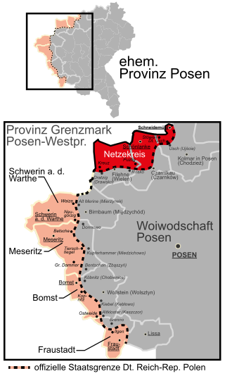
The Netzekreis was a district in Germany from 1919 to 1945. For most of its existence, it was part of the Prussian Province of Posen-West Prussia. Its administrative seat was the town of Schönlanke. Today the territory of the district is part of the Greater Poland Voivodeship in Poland.
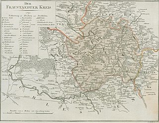
The Fraustadt district was Prussian district which existed in various borders from 1793 to 1945. From 1793 to 1807 it was located in the Province of South Prussia, from 1815 to 1848 in the Grand Duchy of Posen, from 1848 to 1920 in the Province of Posen, from 1922 to 1938, in the Province of Posen-West Prussia, from 1938 to 1941 in the Province of Silesia and from 1941 to 1945 in the Province of Lower Silesia.


