Streeterville is a neighborhood in the Near North Side community area of Chicago, Illinois, United States, north of the Chicago River. It is bounded by the river on the south, the Magnificent Mile portion of Michigan Avenue on the west, and Lake Michigan on the north and east, according to most sources, although the City of Chicago only recognizes a small portion of this region as Streeterville. Thus, it can be described as the Magnificent Mile plus all land east of it. The tourist attraction of Navy Pier extends out into the lake from southern Streeterville. The majority of the land in this neighborhood is reclaimed sandbar.
Highland Park is a neighborhood in the northeastern part of Pittsburgh, Pennsylvania. Highland Park, the neighborhood, fully encompasses the park with the same name.

The Brush Park Historic District is a neighborhood located in Detroit, Michigan. It is bounded by Mack Avenue on the north, Woodward Avenue on the west, Beaubien Street on the east, and the Fisher Freeway on the south. The Woodward East Historic District, a smaller historic district completely encompassed by the larger Brush Park neighborhood, is located on Alfred, Edmund, and Watson Streets, from Brush Street to John R. Street, and is recognized by the National Register of Historic Places.

The East Side is a district of Milwaukee, Wisconsin consisting of several neighborhoods encompassing an area just north of Downtown Milwaukee to the village of Shorewood, bordered by the Milwaukee River to the west and Lake Michigan to the east. The area encompasses residences, museums, bars, shops, theaters, live music clubs and the University of Wisconsin–Milwaukee campus.

Heritage Hill is a residential neighborhood in Grand Rapids, Michigan. It is listed on the National Register of Historic Places and is one of the largest urban historic districts in the United States. It is bounded by Crescent Street (north), Union Avenue (east), Pleasant Street (south), and Lafayette Avenue (west). Heritage Hill was designated by the American Planning Association as one of 2012's Great Places in America.

The architecture of metropolitan Detroit continues to attract the attention of architects and preservationists alike. With one of the world's recognizable skylines, Detroit's waterfront panorama shows a variety of architectural styles. The post-modern neogothic spires of One Detroit Center refer to designs of the city's historic Art Deco skyscrapers. Together with the Renaissance Center, they form the city's distinctive skyline.
Owen Park is a residential neighborhood and historic district in Tulsa, Oklahoma. Its borders are Edison Avenue on the north, the municipal Owen Park on the east, the Keystone Expressway on the south, and Zenith Avenue on the west. Opened on June 8, 1910, it was Tulsa's first municipal park. The district covers 163.48 acres (66.16 ha), while Owen Park itself covers 24 acres (9.7 ha) on the east side of the District.
Elizabeth takes its name from Elizabeth College, a small Lutheran women's college founded in 1897 on the present-day site of Presbyterian Hospital. The community began in 1891 when a streetcar was established along East Trade Street to the area, making it the second oldest streetcar suburb in Charlotte. Elizabeth began to develop rapidly after 1902, when a trolley line was completed, and was annexed in 1907. Home of Independence Park, the first public park in the city, Elizabeth became one of the most fashionable residential areas in Charlotte in its early days. In 2006 Elizabeth had a population of 3,908.

The Arden Park–East Boston Historic District is a neighborhood located in Detroit, Michigan, bounded on the west by Woodward Avenue, on the north by East Boston Boulevard, on the east by Oakland Avenue, and on the south by Arden Park Boulevard. The area is immediately adjacent to the much larger and better-known Boston-Edison Historic District, which is on the west side of Woodward Avenue, and also close to the Atkinson Avenue which is just south of Boston-Edison. There are 92 homes in the district, all on East Boston or Arden Park Boulevards. Arden Park Boulevard and East Boston Boulevard feature prominent grassy medians with richly planted trees and flowers. The setbacks of the homes are deep, with oversized lots. The district was listed on the National Register of Historic Places in 1982.

The Boston–Edison Historic District is a neighborhood located in Detroit, Michigan. It consists of over 900 homes built on four east/west streets: West Boston Boulevard, Chicago Boulevard, Longfellow Avenue, and Edison Avenue, stretching from Woodward Avenue on the east to Linwood Avenue on the west. It is one of the largest residential historic districts in the nation. It is surrounded by Sacred Heart Major Seminary to the west, the Arden Park-East Boston Historic District and the Cathedral of the Most Blessed Sacrament to the east, and the Atkinson Avenue Historic District to the south. The district was designated a Michigan State Historic Site in 1973 and listed on the National Register of Historic Places in 1975.

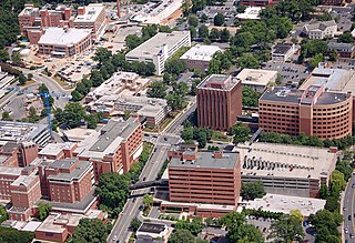
The West Canfield Historic District is a neighborhood historic district located primarily on Canfield Avenue between Second and Third Streets in Detroit, Michigan. A boundary increase enlarged the district to include buildings on Third Avenue between Canfield and Calumet. The district was designated a Michigan State Historic Site in 1970 and listed on the National Register of Historic Places in 1971; a boundary increase was added in 1997. The revitalized 1870s era neighborhood is one of the residential areas surrounding the city's Cultural Center Historic District in Midtown. Nearby, East Canfield Avenue leads to the Detroit Medical Center complex, the Romanesque Revival styled St. Josaphat's Catholic Church, and the Gothic revival styled Sweetest Heart of Mary Catholic Church.

The Warren–Prentis Historic District is a historic district in Detroit, Michigan, including the east–west streets of Prentis, Forest, Hancock, and the south side of Warren, running from Woodward Avenue on the east to Third Avenue on the west. The district was listed on the National Register of Historic Places in 1997.

The Medbury's–Grove Lawn Subdivisions Historic District is a residential historic district located in Highland Park, Michigan. It runs along three east–west streets: Eason Street, Moss Street, and Puritan Street, from Hamilton Avenue on the west to Woodward Avenue on the east. The district was listed on the National Register of Historic Places in 1988.

The East Jefferson Avenue Residential District in Detroit, Michigan, includes the Thematic Resource (TR) in the multiple property submission to the National Register of Historic Places which was approved on October 9, 1985. The structures are single-family and multiple-unit residential buildings with construction dates spanning nearly a century, from 1835 to 1931. The area is located on the lower east side of the city.
Old North Knoxville is a neighborhood in Knoxville, Tennessee, United States, located just north of the city's downtown area. Initially established as the town of North Knoxville in 1889, the area was a prominent suburb for Knoxville's upper middle and professional classes until the 1950s. After a period of decline, preservationists began restoring many of the neighborhood's houses in the 1980s. In 1992, over 400 houses and secondary structures in the neighborhood were added to the National Register of Historic Places as the Old North Knoxville Historic District.

Fourth and Gill is a neighborhood in Knoxville, Tennessee, United States, located north of the city's downtown area. Initially developed in the late nineteenth century as a residential area for Knoxville's growing middle and professional classes, the neighborhood still contains most of its original Victorian-era houses, churches, and streetscapes. In 1985, 282 houses and other buildings in the neighborhood were added to the National Register of Historic Places as the Fourth and Gill Historic District.

The Center Avenue Neighborhood Residential District is a residential historic district located in Bay City, Michigan, running primarily along Center, Fifth, and Sixth Avenues between Monroe and Green Avenues, with additional portions of the district along Fourth between Madison and Johnson, down to Tenth Avenue between Madison and Lincoln, along Green to Ridge, and around Carroll Park. The original section, along Center and portions of Fifth and Sixth, was listed on the National Register of Historic Places in 1982. A boundary increase including the other sections of the neighborhood was listed in 2012.

The Michigan Avenue-Genesee Street Historic Residential District is a primarily residential historic district, located along Michigan Ave between Clinton Street and the railroad tracks, and along Genesee Street from Michigan Avenue to Shiawassee Street in Owosso, Michigan. It was listed on the National Register of Historic Places in 1980.

The North Michigan Avenue Historic District is a residential historic district located along Michigan Avenue, from Monroe Street on the south to just north of Remington Street in Saginaw, Michigan. It was listed on the National Register of Historic Places in 1982.

The Bisbee Residential Historic District is distinct from the Bisbee Historic District, and is located north and west of that district. It developed in the late 1880s and early 1900s, to support the booming mining industry. While it has some multi-family dwellings, commercial buildings, and a school, it is primarily composed of single family houses. It also has an extensive system of pedestrian walkways and stairways. Bisbee does not follow a grid pattern, rather its streets wind following the contour of the canyon and gulches. Developed prior to automobiles, it has narrow roads which are steep, and still remains a pedestrian-oriented town. It consists of over 500 contributing buildings and structures.