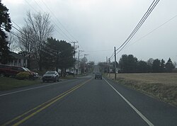
Edenburg, Pennsylvania | |
---|---|
Coordinates: 40°33′59″N75°57′38″W / 40.56639°N 75.96056°W | |
Country | United States |
State | Pennsylvania |
County | Berks |
Township | Windsor |
Area | |
• Total | 0.61 sq mi (1.59 km2) |
• Land | 0.58 sq mi (1.49 km2) |
• Water | 0.04 sq mi (0.10 km2) |
Population | |
• Total | 708 |
• Density | 1,227.04/sq mi (473.66/km2) |
Time zone | UTC-5 (Eastern (EST)) |
• Summer (DST) | UTC-4 (EDT) |
ZIP code | 19526 [3] |
Area code(s) | 484, 610 and 835 |
FIPS code | 42-22352 |
Edenburg is a census-designated place [4] in Windsor Township, Berks County, Pennsylvania, United States. It is located along Old Route 22, and very close to I-78, approximately two miles from Hamburg. As of the 2010 census, the population was 681 residents. [5]
Census | Pop. | Note | %± |
---|---|---|---|
2020 | 708 | — | |
U.S. Decennial Census [6] |
The United States had an official estimated resident population of 333,287,557 on July 1, 2022, according to the U.S. Census Bureau. This figure includes the 50 states and the District of Columbia but excludes the population of five unincorporated U.S. territories as well as several minor island possessions. The United States is the third most populous country in the world. The Census Bureau showed a population increase of 0.4% for the twelve-month period ending in July 2022, below the world average annual rate of 0.9%. The total fertility rate in the United States estimated for 2022 is 1.665 children per woman, which is below the replacement fertility rate of approximately 2.1.
Chester Hill is a borough in Clearfield County, Pennsylvania, United States. The population was 821 at the 2020 census.
Bloomfield, commonly known as New Bloomfield, is a borough in, and the county seat of, Perry County, Pennsylvania, United States. It is part of the Harrisburg–Carlisle metropolitan statistical area. The population was 1,244 at the 2020 census.
Claysville is a borough in Washington County, Pennsylvania, United States and part of the Pittsburgh metropolitan area since 1950. The population was 728 at the 2020 census. Claysville Elementary School, part of the McGuffey School District is located in Claysville. It is the birthplace of Benjamin Franklin Jones of the Jones and Laughlin Steel Company.
Cokeburg is a borough in Washington County, Pennsylvania, United States and part of the Pittsburgh metropolitan area since 1950. Founded in 1902, the population was 626 at the 2020 census.
Hickory is a census-designated place located in Mount Pleasant Township, Washington County in the state of Pennsylvania. As of the 2010 census the population was 740 residents.
Alleghenyville is a census-designated place (CDP) in Brecknock Township, Berks County, Pennsylvania, United States. It is located near the Lancaster County line, and is served by the Governor Mifflin School District. As of the 2010 census the population was 1,134.
Grill is a census-designated place in Cumru Township, Berks County, Pennsylvania, United States. It is located just to the east of the borough of Kenhorst at the intersection of PA routes 625 and 724. The area is generally suburban in nature, and is served by the Governor Mifflin School District. As of the 2010 census, the population was 1,468 residents.
Earlston is a census-designated place in West Providence Township, Bedford County, Pennsylvania, in the United States. The population was 1,049 as of the 2020 census. It is located just across the Raystown Branch of the Juniata River from the borough of Everett.
Colony Park is a census-designated place in Spring Township, Berks County, Pennsylvania, United States. It is located just off U.S. 222, approximately one mile northwest of the borough of Wyomissing. As of the 2010 census, the population was 1,076 residents.
Greenfields is a census-designated place in Bern Township, Berks County, Pennsylvania, United States. It is located approximately one mile to the west of the city of Reading at the confluence of the Tulpehocken Creek and Schuylkill River. As of the 2010 census, the population was 1,170 residents.
Muhlenberg Park is a census-designated place in Muhlenberg Township, Berks County, Pennsylvania, United States. The community is located just to the west of the borough of Laureldale. As of the 2010 census, the population was 1,420 residents. Development of the community began in 1915.
Pennside is a census-designated place in Lower Alsace and Exeter Townships in Berks County, Pennsylvania, United States. It is located approximately four miles east of the city of Reading. As of the 2010 census, the population was 4,215 residents.
Grazierville is a census-designated place in Snyder Township, Blair County, Pennsylvania, United States. It is located near I-99 and is approximately one mile to the south of the borough of Tyrone. As of the 2010 census, the population was 665 residents.
Lake Latonka is a census-designated place in Coolspring and Jackson Townships in Mercer County, Pennsylvania, United States. It surrounds the Lake Latonka reservoir. The population was 951 at the 2020 census. It is part of the Hermitage micropolitan area.
Church Hill is a census-designated place located in Armagh and Brown Townships in Mifflin County in the state of Pennsylvania, United States. It is located north of the borough of Burnham. As of the 2010 census, the population was 1,627 residents.
Atlas is a census-designated place located in Mount Carmel Township, Northumberland County in the state of Pennsylvania. The community is located very close to the borough of Mount Carmel along Pennsylvania Route 61. As of the 2010 census the population was 809 residents.
Dewart is a census-designated place located in Delaware Township, Northumberland County in the state of Pennsylvania. The community is located very close to the West Branch Susquehanna River along Pennsylvania Route 405 in far northern Northumberland County. As of the 2010 census the population was 1,471 residents.
Kapp Heights is a census-designated place located in Point Township, Northumberland County in the state of Pennsylvania. The community is located very close to the borough of Northumberland along Pennsylvania Route 147, near the confluence of the West Branch Susquehanna River and Susquehanna Rivers. As of the 2010 census the population was 863 residents.