
The Cypress Hills are a geographical region of hills in southwestern Saskatchewan and southeastern Alberta, Canada.

Shimizu is a small town located at the base of the Hidaka Mountain Range in Tokachi Subprefecture, Hokkaido, Japan. The name Shimizu is taken from the Ainu word "Pekerebetsu", which means bright clean river. As of 2011, the population of the town is 10,243, and its primary source of income is through agriculture. Shimizu, like many other towns in Hokkaido, is undergoing population decline.

Belfair is a census-designated place in Mason County, Washington, United States. Located on the Union River, headwaters of the Hood Canal, a branch of Puget Sound, it serves as the commercial center of North Mason County. The population of the surrounding area swells in the summertime as tourists and nature lovers flock to the Canal and the Olympic Peninsula. The population was 3,931 at the 2010 census.

Araku Valley is a hill station in Visakhapatnam district in the Indian state of Andhra Pradesh, lying 111 km west of Visakhapatnam city. This place is often referred as Ooty of Andhra. It is a valley in the Eastern Ghats inhabited by different tribes.

Western North Carolina is the region of North Carolina which includes the Appalachian Mountains, thus it is often known geographically as the state's Mountain Region. It contains the highest mountains in the Eastern United States. Western North Carolina is sometimes included with upstate South Carolina as the "Western Carolinas", which is also counted as a single media market. The region covers an area of about 11,000 square miles (28,000 km2), and is roughly the size of the state of Massachusetts. The population of the region, as measured by the 2010 U.S. Census, is 1,473,241, which is approximately 15% of North Carolina's total population.
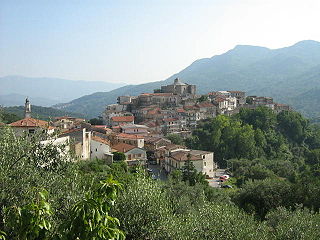
Rofrano is a town and comune of the province of Salerno in the Campania region of south-west Italy. It is located in the southern Cilento. In 2015 its population was 1,539.

Donard is a small village in County Wicklow, Ireland, located at the northern end of the Glen of Imaal, in the western part of the Wicklow Mountains.
Kolli Hills or Kolli Malai is a small mountain range located in central Tamil Nadu in Namakkal district of India. The mountains rise to 1300m in height and cover an area of approximately 280 km². They are part of the Eastern Ghats, which is a mountain range that runs mostly parallel to the east coast of South India. The mountain is a site of pilgrimage, because of the Arapaleeswarar temple, but the area is also popular with hikers.

Alander Mountain, 2,239 feet (682 m), is a prominent peak of the south Taconic Mountains; it is located in southwest Massachusetts and adjacent New York. Part of the summit is grassy and open and part is covered with scrub oak and shrubs; the sides of the mountain are wooded with northern hardwood tree species. Views from the top include the southern Taconic Mountains, the Hudson River Valley including the Catskills. Several trails traverse Alander Mountain, most notably the 15.7 mi (25.3 km) South Taconic Trail, which passes just beneath the summit.
Pujiang is a county of Zhejiang, China. It is under the administration of the Jinhua city.
Old Post No. 43 is a rural municipality in southern Saskatchewan, Canada encompassing 1,757.00 square kilometers in area. The rural municipality in conjunction with the provincial government is in charge of maintenance of highways in its area. As well, the municipality provides policing, fire protection and municipal governance for the rural district, with a reeve as its administrator.

The Marlboro Mountains, sometimes Marlborough Mountains, are a group of hogbacked mountains arranged in a 25-mile-long (40 km) ridge extending from Newburgh, New York to just south of Kingston, New York. Considered to be part of the Ridge and Valley Appalachians, the mountains, which reach elevations over 1,100 feet, form an imposing geologic barrier just west of the Hudson River. They subdivide the relatively flat Hudson River Valley to create the Wallkill Valley further west. Rising abruptly on their eastern flanks, the Marlboro Mountains are known for their sweeping views of the region.

Harvey is an unincorporated community in Fayette County, West Virginia, United States. Harvey is located on County Route 25 2.8 miles (4.5 km) south-southeast of Oak Hill.
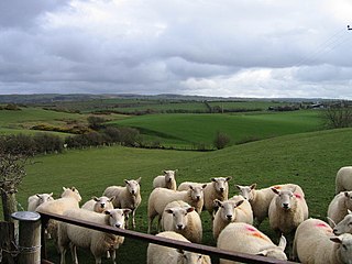
Sheep farming is important to the economy of Wales. Much of Wales is rural countryside and sheep are a very common feature in the landscape throughout the country. The woollen industry in Wales was a major contributor to the national economy, accounting for two-thirds of the nation's exports in 1660. Sheep farms are most often situated in the country's mountains and moorlands, where sheepdogs are employed to round up flocks. Sheep are also reared, however, along the south and west coasts of Wales. In 2017 there were more than 10 million sheep in Wales and the total flock made up nearly 33% of the British total. In 2011 sheep farming accounted for 80% of agriculture in Wales.

Fox Hill is a mountain located in Adirondack Mountains of New York located in the Town of Indian Lake east of Indian Lake.

Wilders Hill is a mountain located in Central New York Region of New York east of Richfield Springs, New York. Waiontha Mountain is located southeast of Wilders Hill.
Grays Mountain is a mountain located in the Catskill Mountains of New York southeast of Bovina Center. Grays Mountain is located south of Mount Pisgah, southwest of Farmers Hill, west-northwest of Fords Hill and north of Dingle Hill.
Red Hill is a mountain located in the Catskill Mountains of New York east-south of Frost Valley. Woodhull Mountain is located northeast of Red Hill.
Van Loan Hill is a mountain in Greene County, New York. It is located in the Catskill Mountains southwest of Maplecrest. Round Hill is located west, Elm Ridge is located north-northeast, and East Jewett Range is located south of Van Loan Hill.


