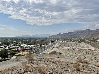
Rancho Mirage is a city in Riverside County, California, United States. The city is a low-density desert community with resorts, golf courses, and country clubs within the Colorado Desert section of the Sonoran Desert. Nestled along the foothills of the Santa Rosa Mountains in the south, it is located several minutes east of Palm Springs. The city is adjacent to Cathedral City, Palm Desert, and unincorporated Thousand Palms. The population was 16,999 at the 2020 census, down from 17,218 at the 2010 census, though the seasonal population can exceed 20,000. Incorporated in 1973, Rancho Mirage is one of the nine cities of the Coachella Valley.

Richmond Hill is a city in Bryan County, Georgia, United States. The population was 16,633 at the 2020 U.S. census, an increase of almost 80% from the 2010 population of 9,281. Richmond Hill is part of the Savannah metropolitan statistical area.

Kingsford is a city in Dickinson County, Michigan, United States. Its population was 5,139 at the 2020 census, a slight increase from the 5,133 recorded at the 2010 census. It was named for the developer Edward G. Kingsford.

Columbia Township is one of the twelve townships of Hamilton County, Ohio, United States. The 2020 census found 4,446 people in the township. Originally one of Ohio's largest townships by area at its inception in 1791, it gradually shrank to one of the smallest by the early 1950s.

The Boston Mountains is a Level III ecoregion designated by the Environmental Protection Agency (EPA) in the U.S. states of Arkansas and Oklahoma. Part of the Ozarks, the Boston Mountains are a deeply dissected plateau. The ecoregion is steeper than the adjacent Springfield Plateau to the north, and bordered on the south by the Arkansas Valley. The Oklahoma portion of the range is locally referred to as the Cookson Hills. There are several theories of how the mountains were named, though apparently none are related to the Massachusetts city.

The Thiel Mountains are isolated, mainly snow-capped mountains of the Transantarctic Mountains System, located in the Ellsworth Land region of Antarctica. The mountain range is 45 nautical miles long, is located roughly between the Horlick Mountains and the Pensacola Mountains, and extends from Moulton Escarpment on the west to Nolan Pillar on the east. Major components include Ford Massif, Bermel Escarpment and a group of eastern peaks near Nolan Pillar.

Black Hills National Forest is located in southwestern South Dakota and northeastern Wyoming, United States. The forest has an area of over 1.25 million acres (5,066 km2) and is managed by the Forest Service. Forest headquarters are located in Custer, South Dakota. There are local ranger district offices in Custer, Rapid City, and Spearfish in South Dakota, and in Sundance, Wyoming.

Beaver Creek is an unincorporated community in Eagle County, Colorado, United States. Beaver Creek is located immediately south of the town of Avon and encompasses the Beaver Creek Resort and adjacent business, lodging, golf course, and residential areas. The U.S. Post Office at Avon serves Beaver Creek postal addresses.

Located in Lower Merion Township, Montgomery County, Pennsylvania, United States, Belmont Hills is a suburb of Philadelphia. Belmont Hills is a neighborhood within the village of Bala Cynwyd. It is a distinct community with its own public elementary school, public pool, fire department and public library. Belmont Hills is known for its hilly terrain. Belmont means "Beautiful Mountain" so its literal name is "Beautiful Mountain Hills".
Warford is a former settlement in Summers County, West Virginia, United States. Warford was located on the New River, east of Pipestem and appeared on maps as late as 1933.
Jarretts Ford is an unincorporated community in Kanawha County, West Virginia, United States.

Rum Hill is a mountain located in Central New York Region of New York northwest of the Hamlet of Pierstown. Red House Hill is located southeast, Metcalf Hill is located south, Allen Lake and Mohegan Hill are located north-northwest and Otsego Lake is located east of Rum Hill.
Frost Hill is a mountain in the Finger Lakes Region of New York. It is located west of Bristol Springs in Ontario County. At an elevation of 2,284 feet (696 m), the mountain is the highest point in Ontario County. It is about 1.25 miles (2.01 km) southwest of the 2,150-foot (660 m) Worden Hill, where Bristol Mountain Ski Resort is.
Mount Pisgah is a mountain located in the Catskill Mountains of New York southeast of Bovina Center. Grays Mountain, Fords Hill, and Dingle Hill are located south of Mount Pisgah.
Grays Mountain is a mountain located in the Catskill Mountains of New York southeast of Bovina Center. Grays Mountain is located south of Mount Pisgah, southwest of Farmers Hill, west-northwest of Fords Hill and north of Dingle Hill.
Meekers Hill is a mountain located in the Catskill Mountains of New York southeast of Andes. Dingle Hill is located northwest, and Fords Hill is located northwest of Meekers Hill.
Red Hill is a mountain located in the Catskill Mountains of New York east-south of Frost Valley. Woodhull Mountain is located northeast of Red Hill.
Gallis Hill is a 794-foot-tall (242 m) mountain in the Catskill Mountains region of New York. It is located northwest of Kingston in Ulster County. Jockey Hill is located north-northeast, and Morgan Hill is located west of Gallis Hill. In 1927, the Conservation Department built a steel fire lookout tower on the mountain. In 1950, the tower was closed and disassembled then moved to Overlook Mountain, where it still remains today.
Leonard Hill is a 2,592-foot-tall (790 m) mountain in Schoharie County, New York. It is located east-southeast of North Blenheim. Safford Hill is located northwest and Hubbard Hill is located southeast of Leonard Hill. In 1948, the Conservation Commission built an 80-foot-tall (24 m) steel fire lookout tower on the mountain. The tower ceased fire watching operations at the end of the 1988 season and was officially closed in early 1989. The tower remains on the summit, but is closed to the public. A local group is planning to restore the tower and reopen it to the public.
Washburn Mountain is a 1,496-foot-tall (456 m) mountain in New York. It is located south-southeast Copake Falls in Columbia County. From 1932 to 1964, the mountain was the location of a 60-foot-tall (18 m) steel fire lookout tower now located on Beebe Hill. Alander Mountain is located southeast of Washburn Mountain.

