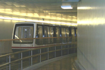
The subway system of the United States Capitol in Washington, D.C., consists of three underground electric people mover systems that connect the United States Capitol to all three of the Senate office buildings and one of the four House office buildings.

The Old Brick Capitol in Washington, D.C., served as the temporary Capitol of the United States from 1815 to 1819. The building was a private school, a boarding house, and, during the American Civil War, a prison known as the Old Capitol Prison. It was demolished in 1929, and its site is now occupied by the U.S. Supreme Court building.

The United States Botanic Garden (USBG) is a botanic garden on the grounds of the United States Capitol in Washington, D.C., near Garfield Circle.
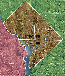
Northeast is the northeastern quadrant of Washington, D.C., the capital of the United States. It encompasses the area located north of East Capitol Street and east of North Capitol Street.
The Washington meridians are four meridians that were used as prime meridians in the United States and pass through Washington, D.C. The four which have been specified are:
- through the Capitol
- through the White House
- through the old Naval Observatory
- through the new Naval Observatory.
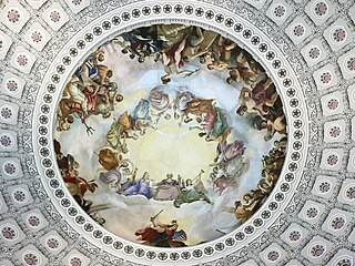
The Apotheosis of Washington is the fresco painted by Greek-Italian artist Constantino Brumidi in 1865 and visible through the oculus of the dome in the rotunda of the United States Capitol Building. The fresco is suspended 180 feet (55 m) above the rotunda floor and covers an area of 4,664 square feet (433.3 m2). The figures painted are up to 15 feet (4.6 m) tall and are visible from the floor below. The dome was completed in 1863, and Brumidi painted it over the course of 11 months at the end of the Civil War. He was paid $40,000 for the fresco.

Aquia Creek is a 27.6-mile-long (44.4 km) tributary of the tidal segment of the Potomac River and is located in northern Virginia. The creek's headwaters lie in southeastern Fauquier County, and it empties into the Potomac at Brent Point in Stafford County, 45 miles (72 km) south of Washington, D.C.
The name "M Street" refers to two major roads in the United States capital of Washington, D.C. Because of the Cartesian coordinate system used to name streets in Washington, the name "M Street" can be used to refer to any east-west street located twelve blocks north or south of the dome of the United States Capitol. Thus, in all four quadrants of the city there are streets called "M Street", which are disambiguated by quadrant designations, namely, M Street NW, NE, SW, and SE.

The congressional office buildings are the office buildings used by the United States Congress to augment the limited space in the United States Capitol. The congressional office buildings are part of the Capitol Complex, and are thus under the authority of the Architect of the Capitol and protected by the United States Capitol Police. The office buildings house the individual offices of each U.S. Representative and Senator as well as committee hearing rooms, staff rooms, multiple cafeterias, and areas for support, committee, and maintenance staff.

Jefferson Pier, Jefferson Stone, or the Jefferson Pier Stone, in Washington, D.C., marks the second prime meridian of the United States even though it was never officially recognized, either by presidential proclamation or by a resolution or act of Congress.

The Thurgood Marshall Federal Judiciary Building (TMFJB) houses offices that support the work of the United States Courts, including the Administrative Office of the United States Courts, the Federal Judicial Center, the United States Sentencing Commission, and the Office of the Clerk of the Judicial Panel on Multidistrict Litigation.

New Hampshire Avenue is a diagonal street in Washington, D.C., beginning at the Kennedy Center and extending northeast for about 5 miles (8 km) and then continuing into Maryland where it is designated Maryland Route 650. New Hampshire Avenue, however, is not contiguous. It stops at 15th and W Streets NW and resumes again on the other side of Columbia Heights at Park Road NW, a few blocks from Georgia Avenue. New Hampshire Avenue passes through several Washington neighborhoods including Foggy Bottom, Dupont Circle, Petworth and Lamond-Riggs.

Westmoreland Circle is a traffic circle straddling the border between the U.S. state of Maryland and the District of Columbia. The circle lies at the intersection of Western Avenue, Butterworth Place, Massachusetts Avenue, Dalecarlia Parkway, Wetherill Road, and Dalecarlia Drive. The grass area and trees within the interior of the circle are maintained by and under the jurisdiction of the National Park Service.

Peace Circle is a traffic circle in Washington, D.C., located at the intersection of Pennsylvania Avenue and First Street NW. At its center is the Peace Monument, also known as the Naval Memorial. It is a monument to the naval deaths during the American Civil War. The monument is topped by the allegorical sculptures of Grief and History. On the southeast side facing the United States Capitol there is a figure of Peace, and on the northwest side, there are figures of Victory and the babies Mars and Neptune. The monument is located on Capitol grounds adjacent to the Capitol Reflection Pool. The monument was sculpted by Franklin Simmons and completed in 1878. The monument was restored in the 1990s.

Downtown is a neighborhood of Washington, D.C., as well as a colloquial name for the central business district in the northwest quadrant of the city. Historically, the Downtown has been defined as an area east of 16th Street NW, north of the National Mall/US Capitol complex, and south of Massachusetts Avenue, including the Penn Quarter. However, the city says that most residents, workers, and visitors think of Downtown in a broader sense—including areas as far north as Dupont Circle, the Golden Triangle, as far west as Foggy Bottom, and as far east as Capitol Hill. A small portion of this area is known as the Downtown Historic District and was listed on the NRHP in 2001.
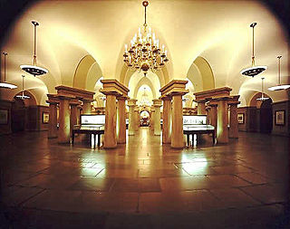
The United States Capitol crypt is the large circular room filled with forty neoclassical Doric columns directly beneath the United States Capitol rotunda. It was built originally to support the rotunda as well as offer an entrance to Washington's Tomb. It currently serves as a museum and a repository for thirteen statues of the National Statuary Hall Collection.

The Capitol Reflecting Pool is a reflecting pool in Washington, D.C., United States. It lies to the west of the United States Capitol and is the westernmost element of the Capitol grounds. The Capitol Dome and the Ulysses S. Grant Memorial are reflected in its waters.

The Rescue (1837–1850) is a large marble sculpture group which was assembled in front of the east façade of the United States Capitol building and exhibited there from 1853 until 1958, when it was removed and never restored. The sculptural ensemble was created by sculptor Horatio Greenough (1805–1852) who had previously been commissioned by the U.S. government to create a massive sculpture, George Washington (1832–1841) for the Capitol rotunda, also now removed from that site.

Chevy Chase Circle is a traffic circle straddling the border of Chevy Chase, Washington, D.C. and Chevy Chase, Maryland. It sits upon the convergence of Western Avenue, Grafton Street, Magnolia Parkway, Chevy Chase Parkway NW, and Connecticut Avenue.
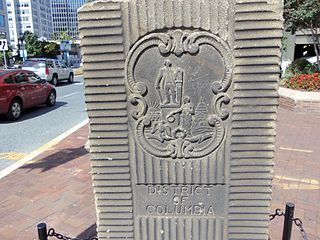
The Garden Club of America Entrance Markers in Washington, D.C. is a Multiple Property Submission, or MPS, on the National Register of Historic Places. The seven structures that make up the MPS are ceremonial markers at important entrance points to the District of Columbia from the state of Maryland. Sets of two markers are located in Westmoreland Circle, Friendship Heights and Chevy Chase Circle. A single marker is located along Georgia Avenue.


