
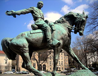
Ward Circle is a traffic circle at the intersection of Nebraska and Massachusetts avenues in Northwest, Washington, D.C. The circle, totaling 30,243 sq ft (2,809.7 m2), is owned and administered by the National Park Service through its Rock Creek Park unit. The land on three sides of is the campus of American University, while the fourth is occupied by the Nebraska Avenue Complex, home of the headquarters of the Department of Homeland Security. The circle is centered around a statue of Maj. Gen. Artemas Ward, which was donated by Harvard University. Ward Circle was constructed for the sculpture.
The Washington meridians are four meridians that were used as prime meridians in the United States and pass through Washington, D.C.. The four which have been specified are:
- through the Capitol
- through the White House
- through the old Naval Observatory
- through the new Naval Observatory.

Scott Circle is a traffic circle in the northwest quadrant of Washington, D.C., at the junction of Massachusetts Avenue, Rhode Island Avenue, and 16th Street, N.W. N Street stops short of meeting the circle from either direction, and is connected to Rhode Island and Massachusetts avenues through Corregidor Street and Bataan Street.

Thomas Circle is a traffic circle in Northwest Washington, D.C., in the United States. It is located at the intersection of Massachusetts Avenue NW, Vermont Avenue NW, 14th Street NW, and M Street NW. It is named for George Henry Thomas, a Union Army general in the American Civil War.

"NoMa" is a moniker for the area North of Massachusetts Avenue located north and east of Union Station in Washington, D.C., United States. NoMa includes the neighborhoods of Truxton Circle, Sursum Corda, Eckington, and Near Northeast and includes a section historically known as Swampoodle. Its southern tip is four blocks from Capitol Hill. "NoMa", meaning "North of Massachusetts Avenue", is a syllabic abbreviation on the model of other similarly named neighborhoods such as SoHo and Tribeca.

The Thurgood Marshall Federal Judiciary Building (TMFJB) houses offices that support the work of the United States Courts, including the Administrative Office of the United States Courts, the Federal Judicial Center, the United States Sentencing Commission, and the Office of the Clerk of the Judicial Panel on Multidistrict Litigation.
Sheridan Circle is a traffic circle in the Washington, D.C. neighborhood of Embassy Row.
Garfield Circle is a traffic circle at the intersection of Maryland Avenue and First Street in Southwest Washington, D.C. The circle is located adjacent to the Capitol Reflection Pool, the Capitol Building Tours Ticket Booth, and the United States Botanic Garden.

Westmoreland Circle is a traffic circle straddling the border between the U.S. state of Maryland and Washington, D.C. The circle lies at the intersection of Western Avenue, Butterworth Place, Massachusetts Avenue, Dalecarlia Parkway, Wetherill Road, and Dalecarlia Drive. The grass area and trees within the interior of the circle are maintained by and under the jurisdiction of the National Park Service.

Tenley Circle is a traffic circle in the Northwest Washington, D.C. neighborhood of Tenleytown. Tenley Circle lies at the intersection of Nebraska Avenue, Wisconsin Avenue, and Yuma Street.
Sherman Circle is an urban park and traffic circle in the Northwest Washington, D.C. neighborhood of Petworth at the intersection of Illinois Avenue, Kansas Avenue, 7th Street, and Crittenden Street NW. The circle is named in honor of Civil War general William Tecumseh Sherman. Administered by the National Park Service's Rock Creek Park unit, Sherman Circle together with four surrounding triangular parks covers 3.44 acres and is considered by the National Park Service a "cultural landscape."

Peace Circle is a traffic circle in Washington, D.C., located at the intersection of Pennsylvania Avenue and First Street NW. At its center is the Peace Monument, also known as the Naval Memorial. It is a monument to the naval deaths during the American Civil War. The monument is topped by the allegorical sculptures of Grief and History. On the southeast side facing the United States Capitol there is a figure of Peace, and on the northwest side, there are figures of Victory and the babies Mars and Neptune. The monument is located on Capitol grounds adjacent to the Capitol Reflection Pool. The monument was sculpted by Franklin Simmons and completed in 1878. The monument was restored in the 1990s.

Observatory Circle is a street in Washington, D.C. It runs from Calvert Street to Massachusetts Avenue near 34th Street. Established in 1894, the street follows an incomplete loop, forming an arc rather than a circle. Number One Observatory Circle is the official residence of the Vice President of the United States.

18th Street Northwest is a prominent north–south street thoroughfare in the Northwest quadrant of Washington, D.C.

Madison Place is a one-block street located in northwest Washington, D.C., across from the White House. It forms the eastern border of Lafayette Square between Pennsylvania Avenue and H Street NW. Buildings on Madison Place include the Howard T. Markey National Courts Building, the Benjamin Ogle Tayloe House, the Cutts-Madison House, and the Treasury Building Annex. The street is part of the Lafayette Square Historic District.

The Civil War Defenses of Washington were a group of Union Army fortifications that protected the federal capital city, Washington, D.C., from invasion by the Confederate States Army during the American Civil War. The sites of some of these fortifications are within a collection of National Park Service (NPS) properties that the National Register of Historic Places identifies as the Fort Circle. The sites of other such fortifications in the area have become parts of state, county or city parks or are located on privately owned properties.

1520 New Hampshire Avenue, NW is located in the Dupont Circle neighbourhood of Washington, D.C.. It has had a number of notable owners, and is currently home to the Embassy of Jamaica to the United States of America.
Golden Triangle, Washington DC is a neighborhood and business improvement district(BID) in Washington, D.C. Its location encompasses most of Washington’s central business district, and runs from the front yard of the White House north to Dupont Circle and from 16th Street to 21st Street NW and includes sections of K Street and Connecticut Avenue. The Golden Triangle BID was created in 1997 by the District of Columbia City Council and approved by Mayor Marion Barry. The commercial neighborhood that is home to more than 3,000 organizations such as top law firms, lobbyists, associations, and architecture firms; 200 restaurants; 300 shops and retailers; 7 hotels; and 6 national parks. Through a special assessment collected from property owners in a 43-block area, the Golden Triangle BID promotes and supports this area of downtown Washington DC through a number of services that include an Ambassador program focusing on cleanliness and hospitality, homeless outreach, streetscape improvements, marketing, outdoor summer concerts and other events, member services and more. Businesses that are located within the boundaries of the Golden Triangle BID are automatically members of the BID. The BID is governed by a Board of Directors composed of twenty-four property and business owners.

Chevy Chase Circle is a traffic circle straddling the border of Chevy Chase, Washington, D.C. and Chevy Chase, Maryland. The circle sits upon the convergence of Western Avenue, Grafton Street, Magnolia Parkway, Chevy Chase Parkway NW, and Connecticut Avenue. In the center of the circle is a fountain dedicated to Representative and Senator Francis Griffith Newlands of Nevada.
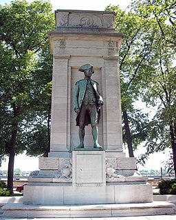
American Revolution Statuary is a group of fourteen statues in Washington, D.C., listed with the National Register of Historic Places. The statues are scattered across Washington, mainly in squares and traffic circles, with four statues of European officers displayed in Lafayette Square, across from the White House


